
Bestand:2010 Maule earthquake intensity USGS.jpg

Grootte van deze voorvertoning: 510 × 599 pixels. Andere resoluties: 204 × 240 pixels | 612 × 719 pixels.
Oorspronkelijk bestand (612 × 719 pixels, bestandsgrootte: 110 kB, MIME-type: image/jpeg)
| Dit is een bestand van Wikimedia Commons. Onderstaande beschrijving komt van de beschrijving van het bestand daar. |
Beschrijving
| Beschrijving |
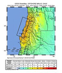
English: Shake map of the magnitude 8.8 earthquake offshore Chile on February 27, 2010. Epicenter marked at star. Seventh version of the map, realized by USGS on 5 March 2010 at 03:00:13 AM MST. |
| Datum | |
| Bron | USGS |
| Auteur | USGS |
| Cameralocatie | | Deze en andere afbeeldingen in: OpenStreetMap |
|---|
Licentie
Deze afbeelding bevindt zich in het publiek domein omdat het materiaal bevat dat oorspronkelijk afkomstig is van de United States Geological Survey, een agentschap van de United States Department of the Interior. Voor meer informatie, zie het officiële USGS-auteursrechtenbeleid
|
Bestandsgeschiedenis
Klik op een datum/tijd om het bestand te zien zoals het destijds was.
| Datum/tijd | Miniatuur | Afmetingen | Gebruiker | Opmerking | |
|---|---|---|---|---|---|
| huidige versie | 15 aug 2013 04:30 | | 612 × 719 (110 kB) | Adelpine | Update to 10th version |
| 21 mrt 2010 23:20 |  | 612 × 720 (99 kB) | Adelpine | ||
| 2 mrt 2010 19:31 |  | 612 × 720 (100 kB) | RapidR~commonswiki | update to latest map (v6) | |
| 27 feb 2010 10:32 |  | 612 × 713 (107 kB) | Andreas Willow | {{Information |Description={{en|1=Shake map of the magnitude 8.3 earthquake offshore Chile on February 27, 2010. Epicenter marked at star. Second version of the map, realized by USGS on 27 February |
Bestandsgebruik
Dit bestand wordt op de volgende pagina gebruikt:
Globaal bestandsgebruik
De volgende andere wiki's gebruiken dit bestand:
- Gebruikt op ar.wikipedia.org
- Gebruikt op ca.wikipedia.org
- Gebruikt op de.wikipedia.org
- Gebruikt op en.wikipedia.org
- Gebruikt op en.wikinews.org
- Gebruikt op eo.wikinews.org
- Gebruikt op es.wikipedia.org
- Gebruikt op fi.wikinews.org
- Gebruikt op fr.wikipedia.org
- Gebruikt op fr.wikinews.org
- Gebruikt op gl.wikipedia.org
- Gebruikt op hu.wikipedia.org
- Gebruikt op incubator.wikimedia.org
- Gebruikt op it.wikipedia.org
- Gebruikt op it.wikinews.org
- Gebruikt op ja.wikipedia.org
- Gebruikt op ja.wikinews.org
- Gebruikt op ms.wikipedia.org
- Gebruikt op pl.wikipedia.org
- Gebruikt op simple.wikipedia.org
- Gebruikt op sk.wikipedia.org
- Gebruikt op tl.wikipedia.org
- Gebruikt op tr.wikipedia.org
- Gebruikt op tr.wikinews.org
- Gebruikt op zh-min-nan.wikipedia.org
- Gebruikt op zh.wikipedia.org