
Bestand:2011 Canterbury earthquake intensity.jpg
Grootte van deze voorvertoning: 510 × 599 pixels. Andere resoluties: 204 × 240 pixels | 612 × 719 pixels.
Oorspronkelijk bestand (612 × 719 pixels, bestandsgrootte: 90 kB, MIME-type: image/jpeg)
| Dit is een bestand van Wikimedia Commons. Onderstaande beschrijving komt van de beschrijving van het bestand daar. |
Beschrijving
| Beschrijving |
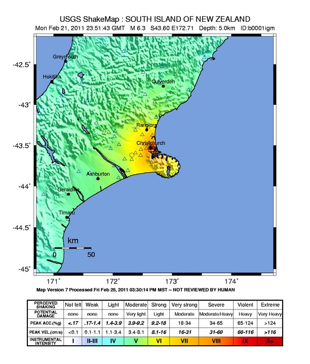
English: Canterbury earthquake intensity map |
| Bron | https://earthquake.usgs.gov/earthquakes/shakemap/global/shake/b0001igm/ |
| Auteur | USGS |
Licentie
Deze afbeelding bevindt zich in het publiek domein omdat het materiaal bevat dat oorspronkelijk afkomstig is van de United States Geological Survey, een agentschap van de United States Department of the Interior. Voor meer informatie, zie het officiële USGS-auteursrechtenbeleid
|
Bestandsgeschiedenis
Klik op een datum/tijd om het bestand te zien zoals het destijds was.
| Datum/tijd | Miniatuur | Afmetingen | Gebruiker | Opmerking | |
|---|---|---|---|---|---|
| huidige versie | 25 mrt 2011 10:54 | | 612 × 719 (90 kB) | Vulcanodong~commonswiki | |
| 22 feb 2011 17:49 |  | 612 × 719 (89 kB) | דקי | {{Information |Description ={{en|1=Canterbury earthquake intensity map}} |Source =http://earthquake.usgs.gov/earthquakes/shakemap/global/shake/b0001igm/ |Author =USGS |Date = |Permission = |other_versions = }} [[Category: |
Bestandsgebruik
Dit bestand wordt op de volgende pagina gebruikt:
Globaal bestandsgebruik
De volgende andere wiki's gebruiken dit bestand:
- Gebruikt op cs.wikipedia.org
- Gebruikt op de.wikipedia.org
- Gebruikt op de.wikinews.org
- Gebruikt op en.wikipedia.org
- Gebruikt op es.wikipedia.org
- Gebruikt op et.wikipedia.org
- Gebruikt op fa.wikipedia.org
- Gebruikt op fr.wikipedia.org
- Gebruikt op fr.wikinews.org
- Gebruikt op hu.wikipedia.org
- Gebruikt op id.wikipedia.org
- Gebruikt op it.wikipedia.org
- Gebruikt op ja.wikipedia.org
- Gebruikt op pl.wikinews.org
- Gebruikt op pt.wikipedia.org
- Gebruikt op sv.wikipedia.org
- Gebruikt op zh.wikipedia.org
- Gebruikt op zh.wikinews.org