
Bestand:2017 Atlantic hurricane season summary map.png

Grootte van deze voorvertoning: 800 × 495 pixels. Andere resoluties: 320 × 198 pixels | 640 × 396 pixels | 1.024 × 634 pixels | 1.280 × 792 pixels | 2.560 × 1.585 pixels | 4.000 × 2.476 pixels.
Oorspronkelijk bestand (4.000 × 2.476 pixels, bestandsgrootte: 6,24 MB, MIME-type: image/png)
| Dit is een bestand van Wikimedia Commons. Onderstaande beschrijving komt van de beschrijving van het bestand daar. |
Beschrijving
| Beschrijving |
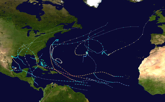
English: This map shows the tracks of all tropical cyclones in the 2017 Atlantic hurricane season. The points show the location of each storm at 6-hour intervals. The colour represents the storm's maximum sustained wind speeds as classified in the Saffir-Simpson Hurricane Scale (see below), and the shape of the data points represent the type of the storm.
Tropical depression (≤38 mph, ≤62 km/h)
Tropical storm (39–73 mph, 63–118 km/h)
Category 1 (74–95 mph, 119–153 km/h)
Category 2 (96–110 mph, 154–177 km/h)
Category 3 (111–129 mph, 178–208 km/h)
Category 4 (130–156 mph, 209–251 km/h)
Category 5 (≥157 mph, ≥252 km/h)
Unknown
Storm type |
| Bron | Created using Wikipedia:WikiProject Tropical cyclones/Tracks. The background image is from NASA [1]. The tracking data is from the National Hurricane Center's Atlantic hurricane database |
| Auteur | Cyclonebiskit |

|
Dit bestand kan geactualiseerd worden om nieuwe informatie te weerspiegelen. Indien je een specifieke versie van het bestand wil gebruiken zonder dat er nieuwe updates plaatsvinden, dien je die betrokken versie te uploaden als een afzonderlijk bestand. |
| Dit werk vrijgegeven in het publieke domein door de auteur, Cyclonebiskit. Dit is wereldwijd van toepassing. In sommige landen is dit wettelijk niet mogelijk; in die gevallen geldt: Cyclonebiskit staat iedereen toe dit werk voor eender welk doel te gebruiken, zonder enige voorwaarden, tenzij zulke voorwaarden door de wet worden voorgeschreven. |
Bestandsgeschiedenis
Klik op een datum/tijd om het bestand te zien zoals het destijds was.
| Datum/tijd | Miniatuur | Afmetingen | Gebruiker | Opmerking | |
|---|---|---|---|---|---|
| huidige versie | 28 nov 2019 17:41 | | 4.000 × 2.476 (6,24 MB) | Supportstorm | Corrected dimensions |
| 28 nov 2019 17:36 |  | 4.000 × 2.472 (6,55 MB) | Supportstorm | Reverted to version as of 08:30, 28 July 2019 (UTC) | |
| 18 okt 2019 01:15 |  | 4.000 × 2.472 (7,66 MB) | MarioProtIV | slightly higher quality | |
| 21 sep 2019 19:06 |  | 4.000 × 2.472 (6,55 MB) | MarioProtIV | Reverted to version as of 08:30, 28 July 2019 (UTC) ok that did nothing | |
| 21 sep 2019 18:59 |  | 4.000 × 2.472 (7,66 MB) | MarioProtIV | fix dot sizes (??? - makes it a little easier to see but idk) | |
| 28 jul 2019 10:30 |  | 4.000 × 2.472 (6,55 MB) | Supportstorm | HURDAT corrections | |
| 18 nov 2018 15:52 |  | 4.000 × 2.472 (7,66 MB) | MarioProtIV | Reverted to version as of 00:20, 13 April 2018 (UTC) unexplained zoom out | |
| 23 okt 2018 04:29 |  | 4.000 × 2.472 (10,13 MB) | Es204L | last | |
| 13 apr 2018 02:20 |  | 4.000 × 2.472 (7,66 MB) | Cyclonebiskit | final TCR update | |
| 9 apr 2018 23:58 |  | 4.000 × 2.472 (7,66 MB) | Cyclonebiskit | Emily, Maria, Nate TCRs |
Bestandsgebruik
Dit bestand wordt op de volgende pagina gebruikt:
Globaal bestandsgebruik
De volgende andere wiki's gebruiken dit bestand:
- Gebruikt op ar.wikipedia.org
- Gebruikt op de.wikipedia.org
- Gebruikt op en.wikipedia.org
- Gebruikt op es.wikipedia.org
- Gebruikt op fi.wikipedia.org
- Gebruikt op fr.wikipedia.org
- Gebruikt op ga.wikipedia.org
- Gebruikt op hu.wikipedia.org
- Gebruikt op id.wikipedia.org
- Gebruikt op it.wikipedia.org
- Gebruikt op ko.wikipedia.org
- Gebruikt op pt.wikipedia.org
- Gebruikt op simple.wikipedia.org
- Gebruikt op ta.wikipedia.org
- Gebruikt op th.wikipedia.org
- Gebruikt op www.wikidata.org
- Gebruikt op zh.wikipedia.org
Globaal gebruik van dit bestand bekijken.