
Bestand:2022 Atlantic hurricane season summary map.png
Grootte van deze voorvertoning: 800 × 495 pixels. Andere resoluties: 320 × 198 pixels | 640 × 396 pixels | 1.024 × 634 pixels | 1.280 × 792 pixels | 2.560 × 1.585 pixels | 4.000 × 2.476 pixels.
Oorspronkelijk bestand (4.000 × 2.476 pixels, bestandsgrootte: 6,11 MB, MIME-type: image/png)
| Dit is een bestand van Wikimedia Commons. Onderstaande beschrijving komt van de beschrijving van het bestand daar. |
Beschrijving
| Beschrijving |
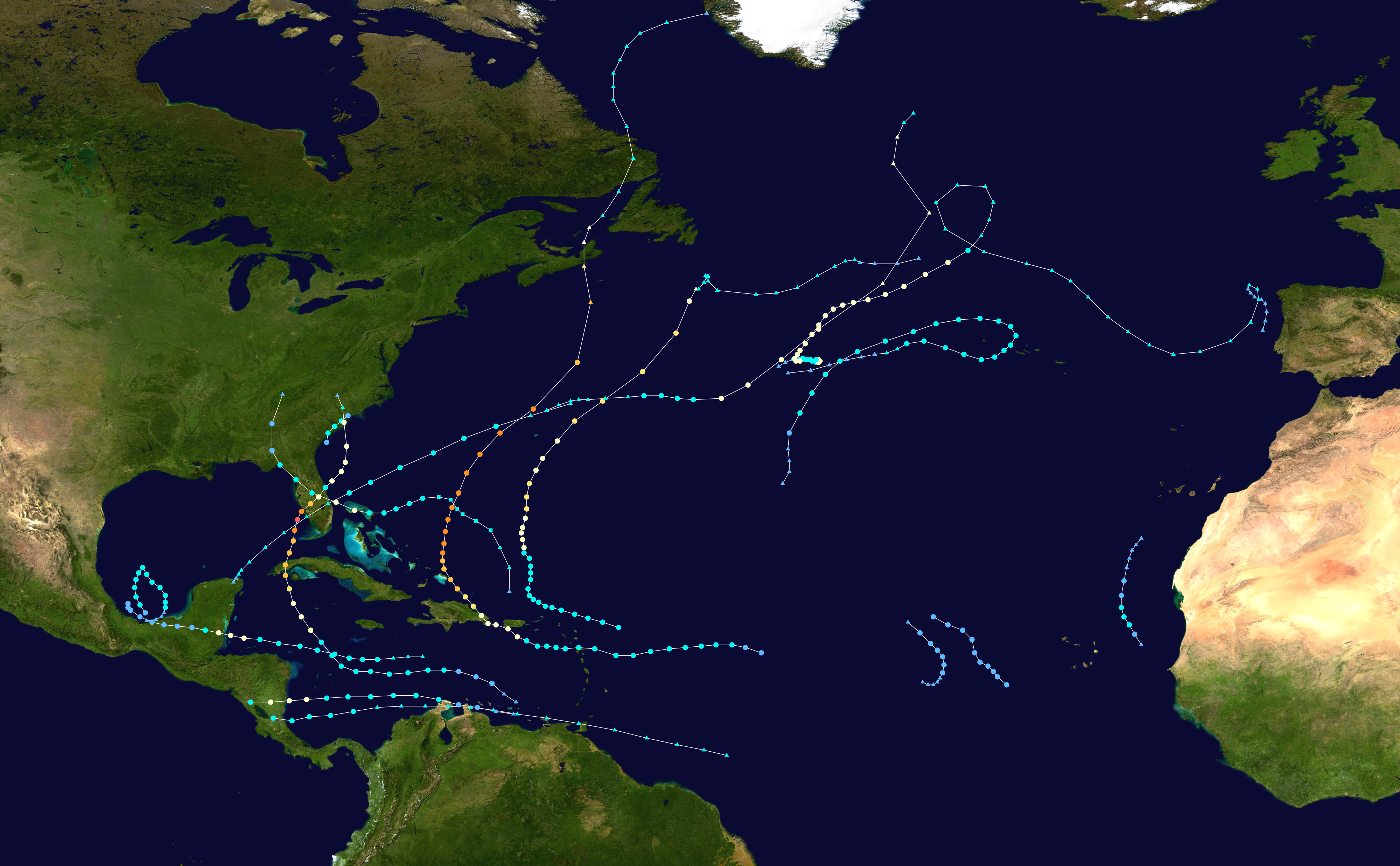
English: This map shows the tracks of all tropical cyclones in the 2022 Atlantic hurricane season. The points show the location of each storm at 6-hour intervals. The colour represents the storm's maximum sustained wind speeds as classified in the Saffir-Simpson Hurricane Scale (see below), and the shape of the data points represent the type of the storm.
Tropical depression (≤38 mph, ≤62 km/h)
Tropical storm (39–73 mph, 63–118 km/h)
Category 1 (74–95 mph, 119–153 km/h)
Category 2 (96–110 mph, 154–177 km/h)
Category 3 (111–129 mph, 178–208 km/h)
Category 4 (130–156 mph, 209–251 km/h)
Category 5 (≥157 mph, ≥252 km/h)
Unknown
Storm type |
| Bron | Created using Wikipedia:WikiProject Tropical cyclones/Tracks. The background image is from NASA [1]. The tracking data is from the National Hurricane Center's Atlantic hurricane database |
| Auteur | HurricaneCovid |

|
Dit bestand kan geactualiseerd worden om nieuwe informatie te weerspiegelen. Indien je een specifieke versie van het bestand wil gebruiken zonder dat er nieuwe updates plaatsvinden, dien je die betrokken versie te uploaden als een afzonderlijk bestand. |
| Dit werk vrijgegeven in het publieke domein door de auteur, HurricaneCovid. Dit is wereldwijd van toepassing. In sommige landen is dit wettelijk niet mogelijk; in die gevallen geldt: HurricaneCovid staat iedereen toe dit werk voor eender welk doel te gebruiken, zonder enige voorwaarden, tenzij zulke voorwaarden door de wet worden voorgeschreven. |
Bestandsgeschiedenis
Klik op een datum/tijd om het bestand te zien zoals het destijds was.
| Datum/tijd | Miniatuur | Afmetingen | Gebruiker | Opmerking | |
|---|---|---|---|---|---|
| huidige versie | 3 apr 2023 16:59 | | 4.000 × 2.476 (6,11 MB) | Supportstorm | All TCR tracks |
| 19 mrt 2023 23:12 |  | 4.000 × 2.476 (6,16 MB) | Supportstorm | TCR updates | |
| 4 mrt 2023 01:49 |  | 4.000 × 2.476 (6,2 MB) | Supportstorm | TCR updates | |
| 16 dec 2022 20:47 |  | 4.000 × 2.476 (6,21 MB) | Supportstorm | 11L TCR | |
| 20 nov 2022 20:35 |  | 4.000 × 2.476 (6,22 MB) | Supportstorm | Updated | |
| 10 nov 2022 02:14 |  | 4.000 × 2.476 (6,21 MB) | Supportstorm | Updated | |
| 4 nov 2022 01:31 |  | 4.000 × 2.476 (6,18 MB) | Supportstorm | Updated | |
| 3 nov 2022 05:25 |  | 4.000 × 2.476 (6,17 MB) | Master0Garfield | fix | |
| 3 nov 2022 05:24 |  | 4.000 × 2.476 (6,17 MB) | Master0Garfield | Update | |
| 6 okt 2022 02:52 |  | 4.000 × 2.476 (6,16 MB) | Supportstorm | Updated |
Bestandsgebruik
Dit bestand wordt op de volgende pagina gebruikt:
Globaal bestandsgebruik
De volgende andere wiki's gebruiken dit bestand:
- Gebruikt op de.wikipedia.org
- Gebruikt op en.wikipedia.org
- Gebruikt op es.wikipedia.org
- Gebruikt op fi.wikipedia.org
- Gebruikt op fr.wikipedia.org
- Gebruikt op it.wikipedia.org
- Gebruikt op ko.wikipedia.org
- Gebruikt op pt.wikipedia.org
- Temporada de furacões no Atlântico de 2022
- Predefinição:Temporada de furacões no Atlântico de 2022
- Tempestade tropical Alex (2022)
- Furacão Bonnie (2022)
- Furacão Fiona
- Furacão Ian
- Furacão Julia (2022)
- Ciclones tropicais em 2022
- Furacão Nicole (2022)
- Cronologia da temporada de furacões no Atlântico de 2022
- Gebruikt op simple.wikipedia.org
- Gebruikt op th.wikipedia.org
- Gebruikt op vi.wikipedia.org
- Gebruikt op www.wikidata.org
- Gebruikt op zh.wikipedia.org