
Bestand:2 6 tectomap2.png
Grootte van deze voorvertoning: 406 × 599 pixels. Andere resoluties: 162 × 240 pixels | 325 × 480 pixels | 752 × 1.110 pixels.
Oorspronkelijk bestand (752 × 1.110 pixels, bestandsgrootte: 49 kB, MIME-type: image/png)
| Dit is een bestand van Wikimedia Commons. Onderstaande beschrijving komt van de beschrijving van het bestand daar. |
Beschrijving
| Beschrijving |
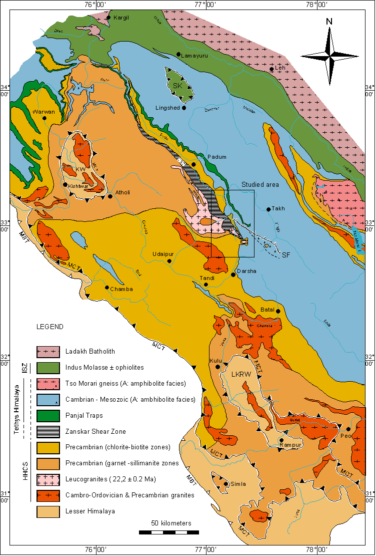
English: Tectonic map of the NW Himalaya.
Geological Map of the NW Himalaya, compiled after the work of:
|
| Datum | |
| Bron | Verplaatst vanaf en.wikipedia naar Commons. |
| Auteur | Original uploader was Moumine at en.wikipedia |
| Toestemming (Hergebruik van dit bestand) |
See below. This image comes from an online verson of the PhD thesis of Pierre Dèzes (1999; Institut de Mineralogie et Petrographie, Université de Lausanne). Dèzes gives permission for "Documents on this site can be used inasmuch as reference is clearly made to the above-mentioned publication and/or this website". |
Licentie

|
De auteursrechthebbende van dit bestand, Pierre Dèzes, staat iedereen toe het voor willekeurig welk doel te gebruiken, mits de auteursrechthebbende correct met naam wordt genoemd.
Heruitgave, afgeleide werken, commercieel gebruik en alle andere vormen van gebruik zijn toegestaan. |
Naamsvermelding:
PhD thesis of Pierre Dèzes 1999, "Tectonic and metamorphic Evolution of the Central Himalayan Domain in Southeast Zanskar (Kashmir, India)". Mémoires de Géologie (Lausanne) No. 32, ISSN 1015-3578 or the website: http://zanskar.geoheritage.ch
|
Oorspronkelijk uploadlogboek
| date/time | username | resolution | size | edit summary |
|---|---|---|---|---|
| 21:42, 2 March 2005 | w:en:User:Moumine | 752×1,110 | 57 KB | tectonic map of the NW Himalaya |
Oorspronkelijk uploadlogboek
| Datum/tijd | Afmetingen | Gebruiker | Opmerking |
|---|---|---|---|
| 25 februari 2008, 19:36:54 | 752 × 1110 (58717 bytes) | BetacommandBot (overleg · bijdragen) | Transwiki approved by: [[w:en:User:Multichill]] {{Information |Description={{en|tectonic map of the NW Himalaya This image comes from an [http://comp1.geol.unibas.ch/zanskar/ online verson] of the PhD thesis of Pierre Dèzes (1999; Institut de Mineral |
Bestandsgeschiedenis
Klik op een datum/tijd om het bestand te zien zoals het destijds was.
| Datum/tijd | Miniatuur | Afmetingen | Gebruiker | Opmerking | |
|---|---|---|---|---|---|
| huidige versie | 23 jul 2014 16:04 | | 752 × 1.110 (49 kB) | GifTagger | Bot: Converting file to superior PNG file. (Source: 2_6_tectomap2.gif). This GIF was problematic due to non-greyscale color table. |
Bestandsgebruik
Dit bestand wordt op de volgende pagina gebruikt:
Globaal bestandsgebruik
De volgende andere wiki's gebruiken dit bestand:
- Gebruikt op en.wikipedia.org
- Gebruikt op fr.wikipedia.org
- Gebruikt op ru.wikipedia.org
- Gebruikt op uk.wikipedia.org