
Bestand:7 subway extension and hudson yards.svg

Afmetingen van deze voorvertoning van het type PNG van dit SVG-bestand: 700 × 400 pixels Andere resoluties: 320 × 183 pixels | 640 × 366 pixels | 1.024 × 585 pixels | 1.280 × 731 pixels | 2.560 × 1.463 pixels.
Oorspronkelijk bestand (SVG-bestand, nominaal 700 × 400 pixels, bestandsgrootte: 100 kB)
| Dit is een bestand van Wikimedia Commons. Onderstaande beschrijving komt van de beschrijving van het bestand daar. |
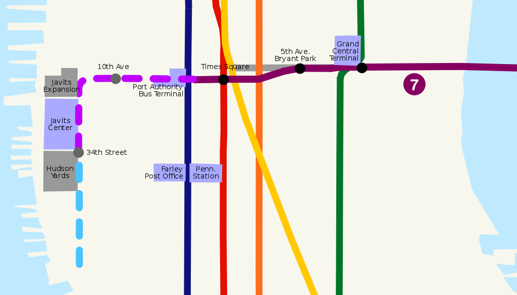
| Beschrijving | Route map of New York City Subway 7 Subway Extension, including planned station stops and hudson yards development. | ||
| Datum | |||
| Bron | self-made, based on Image:NYCS map 7.svg, Image:NYCS-bull-trans-7.svg and USGS topographical map | ||
| Auteur | ChrisRuvolo | ||
| Toestemming (Hergebruik van dit bestand) |
|
Bestandsgeschiedenis
Klik op een datum/tijd om het bestand te zien zoals het destijds was.
| Datum/tijd | Miniatuur | Afmetingen | Gebruiker | Opmerking | |
|---|---|---|---|---|---|
| huidige versie | 14 jul 2008 20:32 | | 700 × 400 (100 kB) | ChrisRuvolo | add 7 line bullet |
| 7 jul 2008 04:59 |  | 700 × 400 (100 kB) | ChrisRuvolo | change coloration to match line map | |
| 21 jan 2008 21:43 |  | 700 × 400 (99 kB) | ChrisRuvolo | fix stations | |
| 21 jan 2008 21:37 |  | 700 × 400 (99 kB) | ChrisRuvolo | {{Information |Description=Route map of New York City Subway en:7 Subway Extension, including planned station stops and hudson yards development. |Source=self-made, based on Image:NYCS map 7.svg and USGS topographical map |Date=2007-01-21 |Auth |
Bestandsgebruik
Geen enkele pagina gebruikt dit bestand.
Globaal bestandsgebruik
De volgende andere wiki's gebruiken dit bestand:
- Gebruikt op de.wikipedia.org
- Gebruikt op en.wikipedia.org
- Gebruikt op es.wikipedia.org
- Gebruikt op it.wikipedia.org
- Gebruikt op ja.wikipedia.org
- Gebruikt op www.wikidata.org
- Gebruikt op zh.wikipedia.org