
Bestand:Adpar and the county boundary - geograph.org.uk - 919887.jpg
Geen hogere resolutie beschikbaar.
Adpar_and_the_county_boundary_-_geograph.org.uk_-_919887.jpg (640 × 480 pixels, bestandsgrootte: 81 kB, MIME-type: image/jpeg)
| Dit is een bestand van Wikimedia Commons. Onderstaande beschrijving komt van de beschrijving van het bestand daar. |
Beschrijving
| Beschrijving |
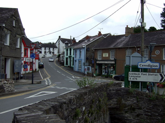
English: Adpar and the county boundary The river is the county boundary, Newcastle Emlyn to the south being in Sir Caerfyrddin and Adpar, seen here, in Sir Ceredigion.
This is an important river crossing where three roads converge: the A475 east from Llanbedr Pont Steffan and B roads from the north and west. Note the position of the letter box in the centre of the image, with a plaque beside it commemorating the site of Wales' first printing press. The house to the right of it was the Salutation Inn, scene of the quarrel that preceded the last duel fought in Wales, nearby, in 1814. See http://www.newcastleemlyn.info/page14.html |
| Datum | |
| Bron | From geograph.org.uk |
| Auteur | ceridwen |
| Naamsvermelding (required by the license) | ceridwen / Adpar and the county boundary / |
| Cameralocatie | | Deze en andere afbeeldingen in: OpenStreetMap |
|---|
_heading:0.00&language=nl)
| Objectlocatie | | Deze en andere afbeeldingen in: OpenStreetMap |
|---|
_heading:0.00&language=nl)
Licentie

|
Deze afbeelding komt uit de Geograph British Isles-collectie. Zie de pagina van deze foto op de website van Geograph voor contactinformatie van de fotograaf. Het auteursrecht van deze foto is in handen van ceridwen en de foto is gelicenceerd voor hergebruik onder de Creative Commons Naamsvermelding-Gelijk delen 2.0 licentie.
|
Dit bestand is gelicenseerd onder de Creative Commons-licentie Naamsvermelding-Gelijk delen 2.0 Unported
Naamsvermelding: ceridwen
- De gebruiker mag:
- Delen – het werk kopiëren, verspreiden en doorgeven
- Remixen – afgeleide werken maken
- Onder de volgende voorwaarden:
- naamsvermelding – U moet op een gepaste manier aan naamsvermelding doen, een link naar de licentie geven, en aangeven of er wijzigingen in het werk zijn aangebracht. U mag dit op elke redelijke manier doen, maar niet zodanig dat de indruk wordt gewekt dat de licentiegever instemt met uw werk of uw gebruik van zijn werk.
- Gelijk delen – Als u het werk heeft geremixt, veranderd, of erop heeft voortgebouwd, moet u het gewijzigde materiaal verspreiden onder dezelfde licentie als het oorspronkelijke werk, of een daarmee compatibele licentie.
Bestandsgeschiedenis
Klik op een datum/tijd om het bestand te zien zoals het destijds was.
| Datum/tijd | Miniatuur | Afmetingen | Gebruiker | Opmerking | |
|---|---|---|---|---|---|
| huidige versie | 22 feb 2011 00:11 | | 640 × 480 (81 kB) | GeographBot | == {{int:filedesc}} == {{Information |description={{en|1=Adpar and the county boundary The river is the county boundary, Newcastle Emlyn to the south being in Sir Caerfyrddin and Adpar, seen here, in Sir Ceredigion. This is an important river crossing wh |
Bestandsgebruik
Dit bestand wordt op de volgende pagina gebruikt:
Globaal bestandsgebruik
De volgende andere wiki's gebruiken dit bestand: