
Bestand:AfricaMap1.jpg
Grootte van deze voorvertoning: 800 × 300 pixels. Andere resoluties: 320 × 120 pixels | 1.202 × 451 pixels.
Oorspronkelijk bestand (1.202 × 451 pixels, bestandsgrootte: 101 kB, MIME-type: image/jpeg)
| Dit is een bestand van Wikimedia Commons. Onderstaande beschrijving komt van de beschrijving van het bestand daar. |
| Beschrijving |
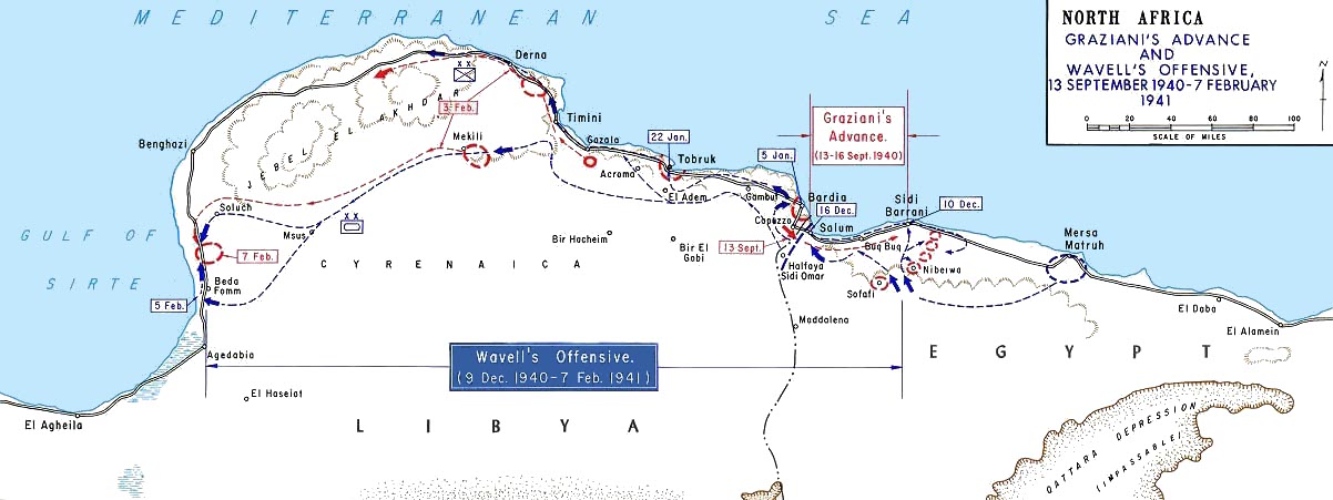
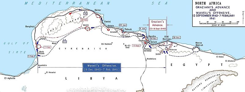
English: Graziani's advance and Wavell's offensive -- en:September 13, en:1940 - en:February 7, en:1941
Français : Avancée de l'armée italienne de Rodolfo Graziani en septembre 1940. |
|||
| Datum | Datum onbekend, after 1938 | |||
| Bron | Older version of Map 34 at http://www.dean.usma.edu/history/web03/atlases/ww2%20europe/WWIIEuropeIndex.html | |||
| Auteur | Department of History at the United States Military Academy | |||
| Toestemming (Hergebruik van dit bestand) |
|


This file was reviewed on 12 June 2009 by the administrator or trusted user Jappalang (talk), who confirmed the Public Domain status on that date.
|
Oorspronkelijk uploadlogboek
(All user names refer to en.wikipedia)
- 2004-08-20 12:39 GeneralPatton 1202×451×8 (131506 bytes) Graziani's advance and Wavell's offensive -- [[September 13, 1940]] - [[February 7]], [[1941]]
Bestandsgeschiedenis
Klik op een datum/tijd om het bestand te zien zoals het destijds was.
| Datum/tijd | Miniatuur | Afmetingen | Gebruiker | Opmerking | |
|---|---|---|---|---|---|
| huidige versie | 27 mrt 2011 15:52 | 1.202 × 451 (101 kB) | Hohum | cleanup | |
| 6 mei 2007 15:36 | 1.202 × 451 (128 kB) | Chanueting | {{Information |Description=Graziani's advance and Wavell's offensive -- en:September 13, en:1940 - en:February 7, en:1941 Source: US ARMY License: US Government document. Printed by the Government printing office. Assumed public doma |
Bestandsgebruik
Dit bestand wordt op de volgende 2 pagina's gebruikt:
Globaal bestandsgebruik
De volgende andere wiki's gebruiken dit bestand:
- Gebruikt op ar.wikipedia.org
- Gebruikt op azb.wikipedia.org
- Gebruikt op bg.wikipedia.org
- Gebruikt op ca.wikipedia.org
- Gebruikt op da.wikipedia.org
- Gebruikt op de.wikipedia.org
- Gebruikt op en.wikipedia.org
- Military history of Italy during World War II
- Richard O'Connor
- Via della Vittoria
- Western Desert campaign
- Beda Fomm
- Military history of Australia during World War II
- Portal:Military history of Australia
- Battle of Beda Fomm
- Maletti Group
- Combeforce
- User:Ian Rose/Draft3
- Battle of Sidi Barrani
- Southern Rhodesia in World War II
- Attack on Nibeiwa
- German radio intelligence operations during World War II
- British capture of Tobruk
- Gebruikt op en.wikibooks.org
- Gebruikt op es.wikipedia.org
- Gebruikt op fa.wikipedia.org
- Gebruikt op fi.wikipedia.org
- Gebruikt op fr.wikipedia.org
Globaal gebruik van dit bestand bekijken.