
Bestand:Alba Patera - topography map.png

Grootte van deze voorvertoning: 601 × 599 pixels. Andere resoluties: 241 × 240 pixels | 623 × 621 pixels.
Oorspronkelijk bestand (623 × 621 pixels, bestandsgrootte: 395 kB, MIME-type: image/png)
Dit is een bestand van Wikimedia Commons.
Onderstaande beschrijving komt van de beschrijving van het bestand daar.
Onderstaande beschrijving komt van de beschrijving van het bestand daar.
| Beschrijving |
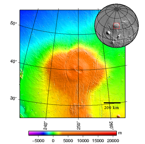
Čeština: Štítová sopka Alba Patera na Marsu - topografická mapa English: Topography map of shield vulcano Alba Patera on Mars |
||||||||
| Datum | 2008-03-see below | ||||||||
| Bron | plotted using GMT and gridded MOLA data archive meg0031t.grd | ||||||||
| Auteur | Chmee2 | ||||||||
| Toestemming (Hergebruik van dit bestand) |
Ik, de auteursrechthebbende van dit werk, maak het hierbij onder de volgende licenties beschikbaar:
Dit bestand is gelicenseerd onder de Creative Commons-licenties Naamsvermelding-Gelijk delen 2.5 Algemeen, 2.0 Algemeen en 1.0 Algemeen.
U mag zelf één van de licenties kiezen. |

Bestandsgeschiedenis
Klik op een datum/tijd om het bestand te zien zoals het destijds was.
| Datum/tijd | Miniatuur | Afmetingen | Gebruiker | Opmerking | |
|---|---|---|---|---|---|
| huidige versie | 11 mrt 2008 00:48 | | 623 × 621 (395 kB) | Chmee2 | {{Information |Description={{cs|Štítová sopka Alba Patera na Marsu - topografická mapa}} {{en|Topography map of shield vulcano Alba Patera on Mars}} |Source=plotted using GMT and gridded MOLA data archive meg0031t.grd |Date=2008-03-see below |Author=[ |
Bestandsgebruik
Dit bestand wordt op de volgende pagina gebruikt:
Globaal bestandsgebruik
De volgende andere wiki's gebruiken dit bestand:
- Gebruikt op ca.wikipedia.org
- Gebruikt op cs.wikipedia.org
- Gebruikt op de.wikipedia.org
- Gebruikt op en.wikipedia.org
- Gebruikt op es.wikipedia.org
- Gebruikt op fa.wikipedia.org
- Gebruikt op fi.wikipedia.org
- Gebruikt op fr.wikipedia.org
- Gebruikt op it.wikipedia.org
- Gebruikt op ja.wikipedia.org
- Gebruikt op ko.wikipedia.org
- Gebruikt op lt.wikipedia.org
- Gebruikt op nn.wikipedia.org
- Gebruikt op no.wikipedia.org
- Gebruikt op pl.wikipedia.org
- Gebruikt op pt.wikipedia.org
- Gebruikt op ru.wikipedia.org
- Gebruikt op uk.wikipedia.org
- Gebruikt op www.wikidata.org
- Gebruikt op zh.wikipedia.org