
Bestand:Amang 2011 track.png

Grootte van deze voorvertoning: 800 × 495 pixels. Andere resoluties: 320 × 198 pixels | 640 × 396 pixels | 1.024 × 633 pixels | 1.280 × 791 pixels | 2.700 × 1.669 pixels.
Oorspronkelijk bestand (2.700 × 1.669 pixels, bestandsgrootte: 486 kB, MIME-type: image/png)
| Dit is een bestand van Wikimedia Commons. Onderstaande beschrijving komt van de beschrijving van het bestand daar. |
Beschrijving
| Beschrijving |
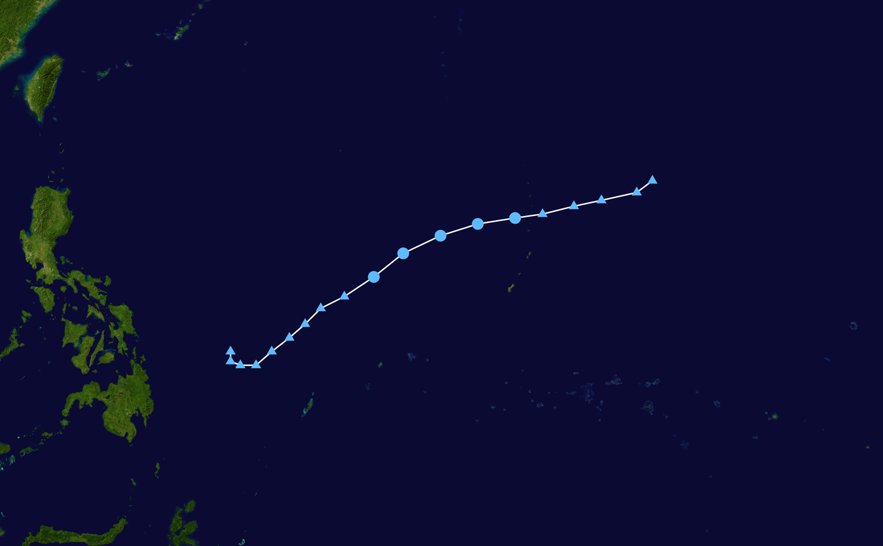
English: Track map of Tropical Depression 02W of the 2011 Pacific typhoon season. The points show the location of the storm at 6-hour intervals. The colour represents the storm's maximum sustained wind speeds as classified in the (see below), and the shape of the data points represent the nature of the storm, according to the legend below. Tropical depression (≤38 mph, ≤62 km/h)
Tropical storm (39–73 mph, 63–118 km/h)
Category 1 (74–95 mph, 119–153 km/h)
Category 2 (96–110 mph, 154–177 km/h)
Category 3 (111–129 mph, 178–208 km/h)
Category 4 (130–156 mph, 209–251 km/h)
Category 5 (≥157 mph, ≥252 km/h)
Unknown
Storm type |
||
| Datum | 2011-04-02–2011-04-07 | ||
| Bron | Created by Supportstorm using Wikipedia:WikiProject Tropical cyclones/Tracks. The background image is from NASA. Tracking data is from the Joint Typhoon Warning Center[1]. | ||
| Auteur | Supportstorm | ||
| Source code | Track map data table, if present below, is in HURDAT2 or ATCF format. See format details in [2] and [3], respectively.
|
Licentie
| Dit werk vrijgegeven in het publieke domein door de auteur, Supportstorm. Dit is wereldwijd van toepassing. In sommige landen is dit wettelijk niet mogelijk; in die gevallen geldt: Supportstorm staat iedereen toe dit werk voor eender welk doel te gebruiken, zonder enige voorwaarden, tenzij zulke voorwaarden door de wet worden voorgeschreven. |
Bestandsgeschiedenis
Klik op een datum/tijd om het bestand te zien zoals het destijds was.
| Datum/tijd | Miniatuur | Afmetingen | Gebruiker | Opmerking | |
|---|---|---|---|---|---|
| huidige versie | 26 sep 2016 18:08 | | 2.700 × 1.669 (486 kB) | Supportstorm | Extended with JMA ET data |
| 23 jul 2013 01:44 |  | 2.700 × 1.669 (654 kB) | Supportstorm | Track generated | |
| 29 sep 2012 18:08 |  | 1.024 × 633 (127 kB) | Supportstorm | Best Track Update | |
| 7 apr 2011 09:57 |  | 1.024 × 633 (188 kB) | Keith Edkins | {{Information |Description={{en|Track map of Tropical Depression Amang of the 2011 Pacific typhoon season (Designated 02W by JTWC). The points show the location |
Bestandsgebruik
Dit bestand wordt op de volgende pagina gebruikt:
Globaal bestandsgebruik
De volgende andere wiki's gebruiken dit bestand:
- Gebruikt op de.wikipedia.org
- Gebruikt op en.wikipedia.org
- Gebruikt op fr.wikipedia.org
- Gebruikt op ja.wikipedia.org
- Gebruikt op pt.wikipedia.org
- Gebruikt op simple.wikipedia.org
- Gebruikt op th.wikipedia.org
- Gebruikt op vi.wikipedia.org
- Gebruikt op zh.wikipedia.org