
Bestand:Ancient Levant routes.png

Grootte van deze voorvertoning: 800 × 541 pixels. Andere resoluties: 320 × 217 pixels | 640 × 433 pixels | 919 × 622 pixels.
Oorspronkelijk bestand (919 × 622 pixels, bestandsgrootte: 290 kB, MIME-type: image/png)
| Dit is een bestand van Wikimedia Commons. Onderstaande beschrijving komt van de beschrijving van het bestand daar. |
Beschrijving
| Beschrijving |
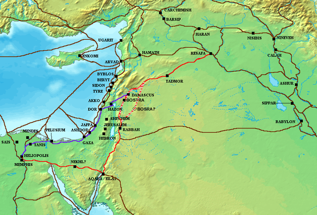
The en:Via Maris (purple), King's Highway (in red), and other ancient en:Levantine en:trade routes, c. en:1300 BCE en:Category:Historical maps by User:Briangotts |
| Datum | 24 mei 2006 (originele uploaddatum) |
| Bron | Verplaatst vanaf en.wikipedia naar Commons. |
| Auteur | Briangotts op de Engelstalige Wikipedia |
Licentie
Briangotts at the English Wikipedia, de auteursrechthebbende van dit werk, maakt het hierbij onder de volgende licentie beschikbaar:

|
Toestemming wordt verleend voor het kopiëren, verspreiden en/of wijzigen van dit document onder de voorwaarden van de GNU-licentie voor vrije documentatie, versie 1.2 of enige latere versie als gepubliceerd door de Free Software Foundation; zonder Invariant Sections, zonder Front-Cover Texts, en zonder Back-Cover Texts. Een kopie van de licentie is opgenomen in de sectie GNU-licentie voor vrije documentatie. |
| Dit bestand is gelicenseerd onder de Creative Commons-licentie Naamsvermelding-Gelijk delen 3.0 Unported | ||
| Naamsvermelding: Briangotts at the English Wikipedia | ||
| ||
| Deze licentietag is toegevoegd aan dit bestand in verband met de GFDL licentie-update. |
Oorspronkelijk uploadlogboek
De oorspronkelijke beschrijving van deze afbeelding stond hier. Alle volgende gebruikersnamen verwijzen naar en.wikipedia.
- 2006-05-24 18:48 Briangotts 919×622×8 (326236 bytes) The [[Via Maris]] (purple), [[King's Highway (ancient)|King's Highway]] (in red), and other ancient [[Levant]]ine [[trade route]]s, c. 1300 BCE]] [[Category:Historical maps by User:Briangotts]]
ATTENTION, il semble que la carte soit fausse, car la vraie Bosra est bien plus a l'Est (voir ma discussion)
Bestandsgeschiedenis
Klik op een datum/tijd om het bestand te zien zoals het destijds was.
| Datum/tijd | Miniatuur | Afmetingen | Gebruiker | Opmerking | |
|---|---|---|---|---|---|
| huidige versie | 4 okt 2010 11:57 | | 919 × 622 (290 kB) | Arpenteur31 | correction of the roman road (Via Nova Traiana), according to geographic coordinates of BOSRA |
| 20 jul 2007 17:15 |  | 919 × 622 (319 kB) | Briangotts | {{Information |Description The Via Maris (purple), King's Highway (in red), and other ancient Levantine trade routes, c. 1300 BCE. |Source=self-made |Date= |Author= Briangotts }} [[Category: | |
| 18 jun 2007 20:09 |  | 919 × 622 (319 kB) | Matthiasb | {{Information |Description=The en:Via Maris (purple), King's Highway (in red), and other ancient en:Levantine en:trade routes, c. en:1300 BCE en:Category:Historical maps by User:Briangotts |Source |
Bestandsgebruik
Dit bestand wordt op de volgende 2 pagina's gebruikt:
Globaal bestandsgebruik
De volgende andere wiki's gebruiken dit bestand:
- Gebruikt op ast.wikipedia.org
- Gebruikt op be.wikipedia.org
- Gebruikt op bg.wikipedia.org
- Gebruikt op bn.wikipedia.org
- Gebruikt op br.wikipedia.org
- Gebruikt op ca.wikipedia.org
- Gebruikt op ceb.wikipedia.org
- Gebruikt op cs.wikipedia.org
- Gebruikt op cv.wikipedia.org
- Gebruikt op da.wikipedia.org
- Gebruikt op de.wikipedia.org
- Gebruikt op de.wikiversity.org
- Gebruikt op de.wikivoyage.org
- Gebruikt op diq.wikipedia.org
- Gebruikt op el.wikipedia.org
- Gebruikt op en.wikipedia.org
- Gebruikt op es.wikipedia.org
- Gebruikt op et.wikipedia.org
- Gebruikt op eu.wikipedia.org
- Gebruikt op fr.wikipedia.org
- Gebruikt op gl.wikipedia.org
- Gebruikt op ha.wikipedia.org
- Gebruikt op he.wikipedia.org
Globaal gebruik van dit bestand bekijken.