
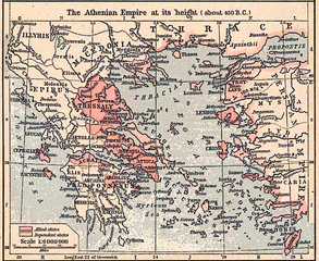
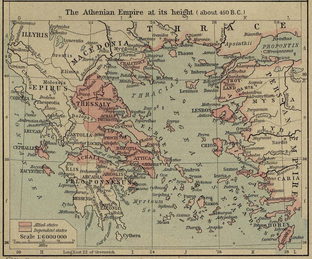
Bestand:Athenian empire atheight 450 shepherd1923.png

Grootte van deze voorvertoning: 733 × 600 pixels. Andere resoluties: 293 × 240 pixels | 587 × 480 pixels | 939 × 768 pixels | 1.094 × 895 pixels.
Oorspronkelijk bestand (1.094 × 895 pixels, bestandsgrootte: 2,02 MB, MIME-type: image/png)
| Dit is een bestand van Wikimedia Commons. Onderstaande beschrijving komt van de beschrijving van het bestand daar. |
Beschrijving
| Beschrijving |
Scan from "Historical Atlas" by William R. Shepherd, New York, Henry Holt and Company, 1926 ed. Original image at the Perry-Castañeda Library Map Collection at the en:University of Texas at Austin website: http://www.lib.utexas.edu/maps/historical/shepherd/athenian_empire_450.jpg From the FAQ @ http://www.lib.utexas.edu/maps/faq.html
This map is not so marked. en:Category:Historical maps by William R. Shepherd |
| Bron | William R. Shepherd |
| Auteur | William R. Shepherd |
Licentie
Dit werk bevindt zich in het publieke domein vanwege het feit dat het in de Verenigde Staten van Amerika werd gepubliceerd tussen 1929 en 1977 zonder enige copyrightvermelding. Tenzij de auteur inmiddels voldoende jaren geleden is overleden is dit werk auteursrechtelijk beschermd in rechtsgebieden die de "regel van de kortere termijn" niet toepassen op Amerikaanse werken, zoals Canada (50 p.m.a.), de Volksrepubliek China (50 p.m.a., m.u.v. Hong Kong en Macau), Duitsland (70 p.m.a.), Mexico (100 p.m.a.), Zwitserland (70 p.m.a.) en andere landen met individuele verdragen. Zie deze Engelstalige pagina voor nadere toelichting.
|
 |
Oorspronkelijk uploadlogboek
De oorspronkelijke beschrijving van deze afbeelding stond hier. Alle volgende gebruikersnamen verwijzen naar en.wikipedia.
- 2006-12-18 22:12 Jengod 1094×895×8 (2117535 bytes) Cleaned up in Elements.
- 2006-12-18 21:31 Jengod 1094×906×8 (1801082 bytes) Scan from "Historical Atlas" by William R. Shepherd, New York, Henry Holt and Company, 1926 ed. Original image at the [http://www.lib.utexas.edu/maps/ Perry-Castañeda Library Map Collection] at the [[University of Texas at Austin]] website: http://www.l
Bestandsgeschiedenis
Klik op een datum/tijd om het bestand te zien zoals het destijds was.
| Datum/tijd | Miniatuur | Afmetingen | Gebruiker | Opmerking | |
|---|---|---|---|---|---|
| huidige versie | 22 feb 2007 15:04 | | 1.094 × 895 (2,02 MB) | Chewie | {{Information |Description=Scan from "Historical Atlas" by William R. Shepherd, New York, Henry Holt and Company, 1926 ed. Original image at the [http://www.lib.utexas.edu/maps/ Perry-Castañeda Library Map Collection] at the [[:en:University of Texas at |
Bestandsgebruik
Dit bestand wordt op de volgende 2 pagina's gebruikt:
Globaal bestandsgebruik
De volgende andere wiki's gebruiken dit bestand:
- Gebruikt op af.wikipedia.org
- Gebruikt op ar.wikipedia.org
- Gebruikt op ca.wikipedia.org
- Gebruikt op cs.wikipedia.org
- Gebruikt op en.wikipedia.org
- Gebruikt op es.wikipedia.org
- Gebruikt op et.wikipedia.org
- Gebruikt op hu.wikipedia.org
- Gebruikt op id.wikipedia.org
- Gebruikt op it.wikipedia.org
- Gebruikt op ko.wikipedia.org
- Gebruikt op ru.wikipedia.org
- Gebruikt op sh.wikipedia.org
- Gebruikt op sk.wikipedia.org
- Gebruikt op sl.wikipedia.org
- Gebruikt op ta.wikipedia.org
- Gebruikt op tr.wikipedia.org
- Gebruikt op zh.wikipedia.org