
Bestand:Avebury World Heritage Site map.svg

Afmetingen van deze voorvertoning van het type PNG van dit SVG-bestand: 679 × 599 pixels Andere resoluties: 272 × 240 pixels | 544 × 480 pixels | 870 × 768 pixels | 1.160 × 1.024 pixels | 2.320 × 2.048 pixels | 1.614 × 1.425 pixels.
Oorspronkelijk bestand (SVG-bestand, nominaal 1.614 × 1.425 pixels, bestandsgrootte: 904 kB)
| Dit is een bestand van Wikimedia Commons. Onderstaande beschrijving komt van de beschrijving van het bestand daar. |
Beschrijving
| Beschrijving |
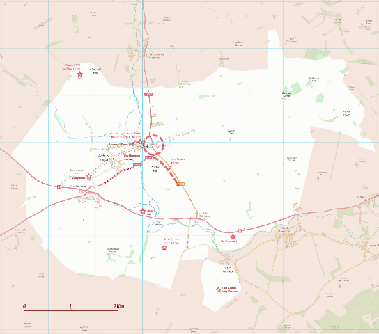
English: Boundary and key sites on the Avebury section of the Stonehenge, Avebury and Associated Sites World Heritage Site |
| Datum | |
| Bron | OS Open Data with additional material cited at World Heritage Site list No 373 |
| Auteur | RobinLeicester building on OS OpenData VextorMap District Raster files |
| Cameralocatie | | Deze en andere afbeeldingen in: OpenStreetMap |
|---|
Licentie
Dit bestand valt onder de Ordnance Survey van de Verenigd Koninkrijk onder de OS OpenData License. In het kort: u kunt het bestand vrij verspreiden en bewerken onder de voorwaarde dat u de Ordnance Survey en het jaar vermeldt.
Naamsvermelding: Contains Ordnance Survey data © Crown copyright and database right (year) Opmerking: Afgeleide werken kunnen vrijgegeven worden onder elke Creative Commons Naamsvermelding 3.0 Licentie. |
.svg)
|
This file is licensed under the United Kingdom Open Government Licence v3.0. |
See also: Meta for information on usage on Wikimedia wikis.
|
Bestandsgeschiedenis
Klik op een datum/tijd om het bestand te zien zoals het destijds was.
| Datum/tijd | Miniatuur | Afmetingen | Gebruiker | Opmerking | |
|---|---|---|---|---|---|
| huidige versie | 28 dec 2014 03:14 | | 1.614 × 1.425 (904 kB) | RobinLeicester | User created page with UploadWizard |
Bestandsgebruik
Dit bestand wordt op de volgende pagina gebruikt:
Globaal bestandsgebruik
De volgende andere wiki's gebruiken dit bestand:
- Gebruikt op en.wikipedia.org
- Gebruikt op fi.wikipedia.org
- Gebruikt op fr.wikipedia.org
- Gebruikt op ja.wikipedia.org
- Gebruikt op kw.wikipedia.org
- Gebruikt op simple.wikipedia.org
- Gebruikt op sl.wikipedia.org
- Gebruikt op vi.wikipedia.org