
Bestand:Basin of Lop Nur 90.25E, 40.10N, Kum Tagh and Astin Tagh.jpg
Geen hogere resolutie beschikbaar.
Basin_of_Lop_Nur_90.25E,_40.10N,_Kum_Tagh_and_Astin_Tagh.jpg (576 × 441 pixels, bestandsgrootte: 176 kB, MIME-type: image/jpeg)
| Dit is een bestand van Wikimedia Commons. Onderstaande beschrijving komt van de beschrijving van het bestand daar. |
Beschrijving
| Beschrijving |
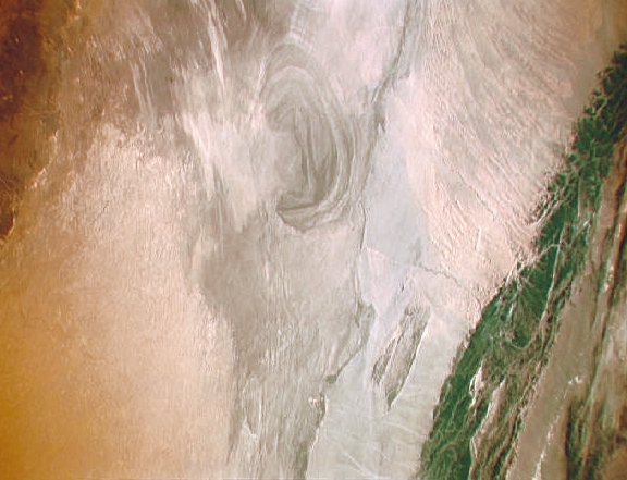
English: China, Xinjiang, desert Lop Nur. Satellite picture of the Basin of the formerly sea Lop Nur in the Desert of Lop Nur. In the foreground Kuruktagh, in the background Kumtagh and Astintagh.
Deutsch: China, Xinjiang, Wüste Lop Nor. Satellitenaufnahme von dem mittleren Teil des Seebeckens Lop Nor und der Wüste Lop Nor. Links im Vordergrund sieht man einen Teil des Gebirges Kuruktagh mit Kratern des Kernwaffentestgeländes, im Hintergrund die Hänge des Kumtagh und die Hochebene des Astintagh. Blick von Nordwesten Richtung Südosten. |
| Datum | tussen 12 september 1992 en 20 september 1992 |
| Bron | NASA Mission: STS047 Roll: 217 Frame: 33 Mission ID on the Film or image: STS47. File name: STS047-217-33.JPG [1] |
| Auteur | NASA. Color adjusting of this image (using Adobe Photoshop 6.0): Michael Gaebler, 02. March 2006, own work, all rights released (Public domain). de: Zugrunde liegt ein noch nicht farbrichtiges Astronauten-Foto der NASA. Diese Fotografie wurde von Michael Gaebler am 02. März 2006 im RGB-Modus mit Adobe Photoshop 6.0 mit Farb- und Tonwertkorrekturen überarbeitet. |
| Toestemming (Hergebruik van dit bestand) |
PD-USGov-NASA |
Deze afbeelding of video is gecatalogiseerd door een van de centrums van de Verenigde Staten National Aeronautics and Space Administration (NASA)onder Foto ID: STS047-217-33.Deze banner zegt niets over de auteursrechten die van toepassing zijn. Een normale auteursrechten-tag is nodig. Zie Commons:Licensing voor meer informatie. Andere talen:
|
Licentie
| Dit bestand bevindt zich in het publiek domein, omdat het gemaakt is door de NASA. In de reproductierichtlijnen van de NASA staat dat "NASA-materiaal niet beschermd wordt door auteursrecht, tenzij anders vermeld". | ||
 |
Waarschuwingen:
|
Bestandsgeschiedenis
Klik op een datum/tijd om het bestand te zien zoals het destijds was.
| Datum/tijd | Miniatuur | Afmetingen | Gebruiker | Opmerking | |
|---|---|---|---|---|---|
| huidige versie | 23 dec 2012 17:57 | | 576 × 441 (176 kB) | Rotatebot | Bot: Image rotated by 90° |
| 6 mrt 2006 02:42 |  | 441 × 585 (178 kB) | Michael Gäbler | {{Information| |Description = en: China, Xinjiang, desert Lop Nur. Satellite picture of the Basin of the formerly sea Lop Nur in the desert of Lop. In the foreground Kuruktagh, in the background Kumtagh and Astintagh. de: China, Xinjiang, W� |
Bestandsgebruik
Dit bestand wordt op de volgende pagina gebruikt:
Globaal bestandsgebruik
De volgende andere wiki's gebruiken dit bestand:
- Gebruikt op ar.wikipedia.org
- Gebruikt op az.wikipedia.org
- Gebruikt op bg.wikipedia.org
- Gebruikt op ca.wikipedia.org
- Gebruikt op de.wikipedia.org
- Gebruikt op en.wikipedia.org
- Gebruikt op en.wikivoyage.org
- Gebruikt op eo.wikipedia.org
- Gebruikt op es.wikipedia.org
- Gebruikt op es.wikivoyage.org
- Gebruikt op et.wikipedia.org
- Gebruikt op gd.wikipedia.org
- Gebruikt op he.wikipedia.org
- Gebruikt op he.wikivoyage.org
- Gebruikt op hi.wikipedia.org
- Gebruikt op hu.wikipedia.org
- Gebruikt op hy.wikipedia.org
- Gebruikt op id.wikipedia.org
- Gebruikt op it.wikipedia.org
- Gebruikt op ka.wikipedia.org
- Gebruikt op kk.wikipedia.org
- Gebruikt op ko.wikipedia.org
- Gebruikt op lt.wikipedia.org
- Gebruikt op mk.wikipedia.org
- Gebruikt op pt.wikipedia.org
- Gebruikt op ru.wikipedia.org
- Gebruikt op sh.wikipedia.org
- Gebruikt op sl.wikipedia.org
- Gebruikt op te.wikipedia.org
- Gebruikt op ug.wikipedia.org
- Gebruikt op www.wikidata.org
- Gebruikt op zh.wikivoyage.org