
Bestand:Belgian local elections map 2012.png

Grootte van deze voorvertoning: 701 × 599 pixels. Andere resoluties: 281 × 240 pixels | 562 × 480 pixels | 899 × 768 pixels | 1.067 × 912 pixels.
Oorspronkelijk bestand (1.067 × 912 pixels, bestandsgrootte: 86 kB, MIME-type: image/png)
| Dit is een bestand van Wikimedia Commons. Onderstaande beschrijving komt van de beschrijving van het bestand daar. |
Beschrijving
| Beschrijving |
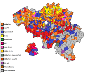
English: This map shows the biggest party/list in every Belgian municipality for the 2012 Belgian municipal elections. |
| Datum | |
| Bron |
https://en.wikipedia.org/wiki/Belgian_local_elections,_2012 Dit bestand is afgeleid van: Belgique-Communes589-Provinces10.gif |
| Auteur | User:Varech |
- Other information
English: Author says it's public domain.
Licentie
| Dit werk vrijgegeven in het publieke domein door de auteur, User:Varech. Dit is wereldwijd van toepassing. In sommige landen is dit wettelijk niet mogelijk; in die gevallen geldt: User:Varech staat iedereen toe dit werk voor eender welk doel te gebruiken, zonder enige voorwaarden, tenzij zulke voorwaarden door de wet worden voorgeschreven.
|
Bestandsgeschiedenis
Klik op een datum/tijd om het bestand te zien zoals het destijds was.
| Datum/tijd | Miniatuur | Afmetingen | Gebruiker | Opmerking | |
|---|---|---|---|---|---|
| huidige versie | 22 sep 2018 12:14 | | 1.067 × 912 (86 kB) | HistorXIII | Reviewed map, found some mistakes, corrected them. |
| 24 jul 2017 15:04 |  | 1.067 × 912 (86 kB) | HistorXIII | {{subst:Upload marker added by en.wp UW}} {{Information |Description = {{en|This map shows the biggest party/list in every Belgian municipality for the 2012 Belgian municipal elections.}} |Source = https://en.wikipedia.org/wiki/Belgian_local_elections,... |
Bestandsgebruik
Dit bestand wordt op de volgende pagina gebruikt:
Globaal bestandsgebruik
De volgende andere wiki's gebruiken dit bestand:
- Gebruikt op en.wikipedia.org
- Gebruikt op fr.wikipedia.org
- Gebruikt op www.wikidata.org