
Bestand:Blake Hall station, near Ongar (geograph 6241574).jpg

Grootte van deze voorvertoning: 800 × 600 pixels. Andere resoluties: 320 × 240 pixels | 640 × 480 pixels | 1.024 × 768 pixels.
Oorspronkelijk bestand (1.024 × 768 pixels, bestandsgrootte: 247 kB, MIME-type: image/jpeg)
| Dit is een bestand van Wikimedia Commons. Onderstaande beschrijving komt van de beschrijving van het bestand daar. |
.jpg)
Beschrijving
| Beschrijving |
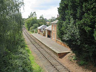
English: Blake Hall station, near Ongar Blake Hall station was opened in 1865, on the railway line linking Epping with Ongar. The station was built as part of an agreement with a landowner, so that the railway line could be built across his land. The station is about a mile from Blake Hall itself, and in a rural part of Essex. The railway line and station passed to London Underground in 1949 and became part of the Central Line. Blake Hall station closed in 1981, and London Underground closed the railway from Epping to Ongar in 1994. However the line has since reopened as a heritage railway. Although part of the station platform has been restored, trains do not stop at Blake Hall. The former station building is now a private residence. |
| Datum | |
| Bron | From geograph.org.uk |
| Auteur | Malc McDonald |
| Toestemming (Hergebruik van dit bestand) |
Creative Commons Attribution Share-alike license 2.0 |
| Naamsvermelding (required by the license) | Malc McDonald / Blake Hall station, near Ongar / |
| Cameralocatie | | Deze en andere afbeeldingen in: OpenStreetMap |
|---|
.jpg¶ms=051.712075_N_0000.203463_E_globe:Earth_type:camera_source:geograph-osgb36(TL52330378)_heading:270.00&language=nl)
| Objectlocatie | | Deze en andere afbeeldingen in: OpenStreetMap |
|---|
.jpg¶ms=051.712080_N_0000.203170_E_globe:Earth_class:object_type:object_source:geograph-osgb36(TL52310378)_heading:270.00&language=nl)
Licentie

|
Deze afbeelding komt uit de Geograph British Isles-collectie. Zie de pagina van deze foto op de website van Geograph voor contactinformatie van de fotograaf. Het auteursrecht van deze foto is in handen van Malc McDonald en de foto is gelicenceerd voor hergebruik onder de Creative Commons Naamsvermelding-Gelijk delen 2.0 licentie.
|
Dit bestand is gelicenseerd onder de Creative Commons-licentie Naamsvermelding-Gelijk delen 2.0 Unported
Naamsvermelding: Malc McDonald
- De gebruiker mag:
- Delen – het werk kopiëren, verspreiden en doorgeven
- Remixen – afgeleide werken maken
- Onder de volgende voorwaarden:
- naamsvermelding – U moet op een gepaste manier aan naamsvermelding doen, een link naar de licentie geven, en aangeven of er wijzigingen in het werk zijn aangebracht. U mag dit op elke redelijke manier doen, maar niet zodanig dat de indruk wordt gewekt dat de licentiegever instemt met uw werk of uw gebruik van zijn werk.
- Gelijk delen – Als u het werk heeft geremixt, veranderd, of erop heeft voortgebouwd, moet u het gewijzigde materiaal verspreiden onder dezelfde licentie als het oorspronkelijke werk, of een daarmee compatibele licentie.
Bestandsgeschiedenis
Klik op een datum/tijd om het bestand te zien zoals het destijds was.
| Datum/tijd | Miniatuur | Afmetingen | Gebruiker | Opmerking | |
|---|---|---|---|---|---|
| huidige versie | 31 okt 2020 18:39 | | 1.024 × 768 (247 kB) | Lamberhurst | Transferred from geograph.co.uk using [https://tools.wmflabs.org/geograph2commons/ geograph2commons] |
Bestandsgebruik
Dit bestand wordt op de volgende pagina gebruikt:
.jpg)