
Bestand:Blake River Megacaldera Complex map.jpg

Grootte van deze voorvertoning: 800 × 478 pixels. Andere resoluties: 320 × 191 pixels | 640 × 382 pixels | 906 × 541 pixels.
Oorspronkelijk bestand (906 × 541 pixels, bestandsgrootte: 229 kB, MIME-type: image/jpeg)
| Dit is een bestand van Wikimedia Commons. Onderstaande beschrijving komt van de beschrijving van het bestand daar. |
Beschrijving
| Beschrijving |
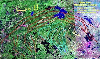
English: Map of the Blake River Megacaldera Complex. |
| Datum | |
| Bron | NASA World Wind |
| Auteur | NASA/Black Tusk |
| Toestemming (Hergebruik van dit bestand) |
NASA, public domain |
Licentie
| Deze afbeelding bevindt zich in het publiek domein omdat het een screenshot is van NASA’s software World Wind die gebruik maakt van een publiek domein-laag, zoals Blue Marble, MODIS, Landsat, SRTM, USGS of GLOBE.
|
 |
Bestandsgeschiedenis
Klik op een datum/tijd om het bestand te zien zoals het destijds was.
| Datum/tijd | Miniatuur | Afmetingen | Gebruiker | Opmerking | |
|---|---|---|---|---|---|
| huidige versie | 14 okt 2008 03:22 | | 906 × 541 (229 kB) | Black Tusk | {{Information |Description={{en|1=Map of the Blake River Megacaldera Complex.}} |Source=NASA World Wind |Author=NASA/Black Tusk |Date=October 13, 2008 |Permission=NASA, public domain |other_versions= }} <!--{{ImageUpload|full}}--> |
Bestandsgebruik
Dit bestand wordt op de volgende pagina gebruikt:
Globaal bestandsgebruik
De volgende andere wiki's gebruiken dit bestand:
- Gebruikt op ar.wikipedia.org
- Gebruikt op arz.wikipedia.org
- Gebruikt op en.wikipedia.org
- Gebruikt op es.wikipedia.org
- Gebruikt op lld.wikipedia.org
- Gebruikt op uk.wikipedia.org
- Gebruikt op www.wikidata.org