
Bestand:Canadian postal district map.svg

Afmetingen van deze voorvertoning van het type PNG van dit SVG-bestand: 709 × 600 pixels Andere resoluties: 284 × 240 pixels | 567 × 480 pixels | 908 × 768 pixels | 1.210 × 1.024 pixels | 2.421 × 2.048 pixels | 1.000 × 846 pixels.
Oorspronkelijk bestand (SVG-bestand, nominaal 1.000 × 846 pixels, bestandsgrootte: 237 kB)
| Dit is een bestand van Wikimedia Commons. Onderstaande beschrijving komt van de beschrijving van het bestand daar. |
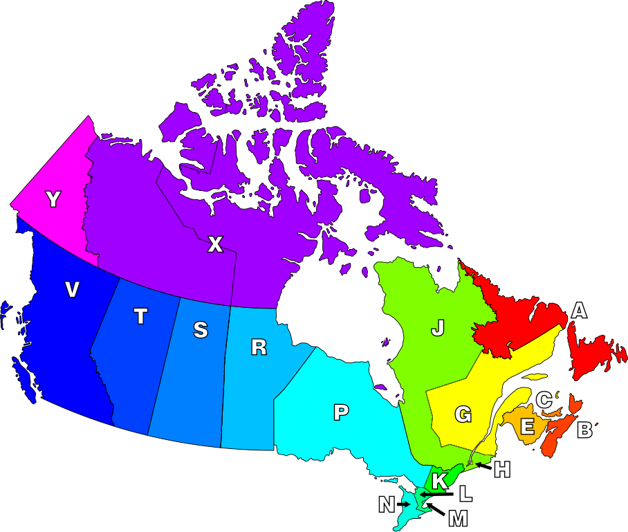
The definition of "postal district" is a geographical area in Canada where all postal codes start with the same letter.
| Beschrijving | Map of Canada highlighting postal districts. | ||
| Datum | |||
| Bron | Own work, based on National Atlas of Canada mapping. | ||
| Auteur | Denelson83 | ||
| Toestemming (Hergebruik van dit bestand) |
|
||
| Andere versies | Image:Canadian Postal Code Map.png |
Bestandsgeschiedenis
Klik op een datum/tijd om het bestand te zien zoals het destijds was.
| Datum/tijd | Miniatuur | Afmetingen | Gebruiker | Opmerking | |
|---|---|---|---|---|---|
| huidige versie | 8 jan 2007 09:21 | | 1.000 × 846 (237 kB) | Denelson83 | Round corners |
| 8 jan 2007 09:18 |  | 1.000 × 846 (236 kB) | Denelson83 | The definition of "postal district" is a geographical area in Canada where all en:Canadian postal codes start with the same letter. {{Information |Description=Map of Canada highlighting postal districts. |Source=Own work, based on National Atlas of |
Bestandsgebruik
Dit bestand wordt op de volgende pagina gebruikt:
Globaal bestandsgebruik
De volgende andere wiki's gebruiken dit bestand:
- Gebruikt op csb.wikipedia.org
- Gebruikt op de.wikipedia.org
- Gebruikt op en.wikipedia.org
- Gebruikt op eo.wikipedia.org
- Gebruikt op fr.wikipedia.org
- Gebruikt op id.wikipedia.org
- Gebruikt op pl.wikipedia.org
- Gebruikt op ta.wikipedia.org