
Bestand:Carretera Central map (Cuba).png
Grootte van deze voorvertoning: 800 × 339 pixels. Andere resoluties: 320 × 136 pixels | 640 × 271 pixels | 1.200 × 509 pixels.
Oorspronkelijk bestand (1.200 × 509 pixels, bestandsgrootte: 107 kB, MIME-type: image/png)
Dit is een bestand van Wikimedia Commons.
Onderstaande beschrijving komt van de beschrijving van het bestand daar.
Onderstaande beschrijving komt van de beschrijving van het bestand daar.
Beschrijving
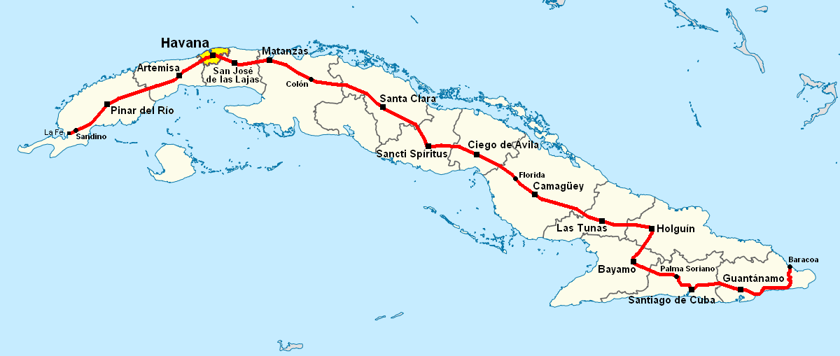
| Beschrijving | Note: A file on EcuRed was updated on 15 February 2013 to a new version, based on this file, updated on 31 January 2013. |
| Datum | 28 juni 2006 (originele uploaddatum) |
| Bron | Geen machineleesbare bron opgegeven. Eigen werk aangenomen (gebaseerd op auteursrechtclaims). |
| Auteur | Geen machineleesbare auteur aanwezig. Op basis van auteursrechtclaims wordt auteur Qyd aangenomen. |
| Andere versies |
|
.png)
.png)
.png)
.png)
.png)
Licentie
| Ik, de auteursrechthebbende van dit werk, geef dit werk vrij in het publieke domein. Dit is wereldwijd van toepassing. In sommige landen is dit wettelijk niet mogelijk; in die gevallen geldt: Ik sta iedereen toe dit werk voor eender welk doel te gebruiken, zonder enige voorwaarden, tenzij zulke voorwaarden door de wet worden voorgeschreven. |
Bestandsgeschiedenis
Klik op een datum/tijd om het bestand te zien zoals het destijds was.
| Datum/tijd | Miniatuur | Afmetingen | Gebruiker | Opmerking | |
|---|---|---|---|---|---|
| huidige versie | 16 nov 2013 18:38 | | 1.200 × 509 (107 kB) | DerBorg | little fix (accent to the "A" of Ciego de Ávila) |
| 31 mei 2013 21:49 |  | 1.200 × 509 (107 kB) | DerBorg | added Florida (the cuban town) | |
| 4 feb 2013 04:31 |  | 1.200 × 509 (107 kB) | DerBorg | little fix | |
| 4 feb 2013 02:28 |  | 1.200 × 509 (107 kB) | DerBorg | little fix (accent to the a of "Guantanamo") | |
| 31 jan 2013 05:12 |  | 1.200 × 509 (107 kB) | DerBorg | little fix | |
| 31 jan 2013 04:57 |  | 1.200 × 509 (107 kB) | DerBorg | Added some fixes to the map: added all the provincial capitals (included the new formed in 2011) crossed by CC, removed San Julian (it's a little village in Sandino municipality, in which starts the road), corrected the Havana-Santa Clara route (in the... | |
| 28 jun 2006 07:50 | 1.068 × 409 (154 kB) | Qyd | Map of Carretera Central in Cuba Category:Maps of Cuba |
Bestandsgebruik
Dit bestand wordt op de volgende pagina gebruikt:
Globaal bestandsgebruik
De volgende andere wiki's gebruiken dit bestand:
- Gebruikt op ca.wikipedia.org
- Gebruikt op de.wikipedia.org
- Gebruikt op en.wikipedia.org
- Gebruikt op eo.wikipedia.org
- Gebruikt op es.wikipedia.org
- Gebruikt op fr.wikipedia.org
- Gebruikt op it.wikipedia.org
- Gebruikt op ka.wikipedia.org
- Gebruikt op lt.wikipedia.org
- Gebruikt op www.wikidata.org
.png)