
Bestand:Carte de la Nièvre.svg

Afmetingen van deze voorvertoning van het type PNG van dit SVG-bestand: 673 × 600 pixels Andere resoluties: 269 × 240 pixels | 539 × 480 pixels | 862 × 768 pixels | 1.150 × 1.024 pixels | 2.299 × 2.048 pixels | 898 × 800 pixels.
Oorspronkelijk bestand (SVG-bestand, nominaal 898 × 800 pixels, bestandsgrootte: 216 kB)
| Dit is een bestand van Wikimedia Commons. Onderstaande beschrijving komt van de beschrijving van het bestand daar. |
Beschrijving
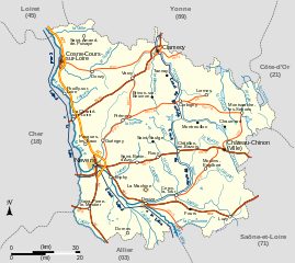
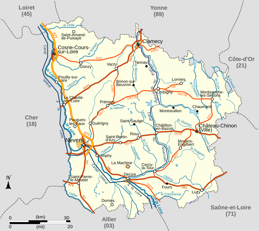
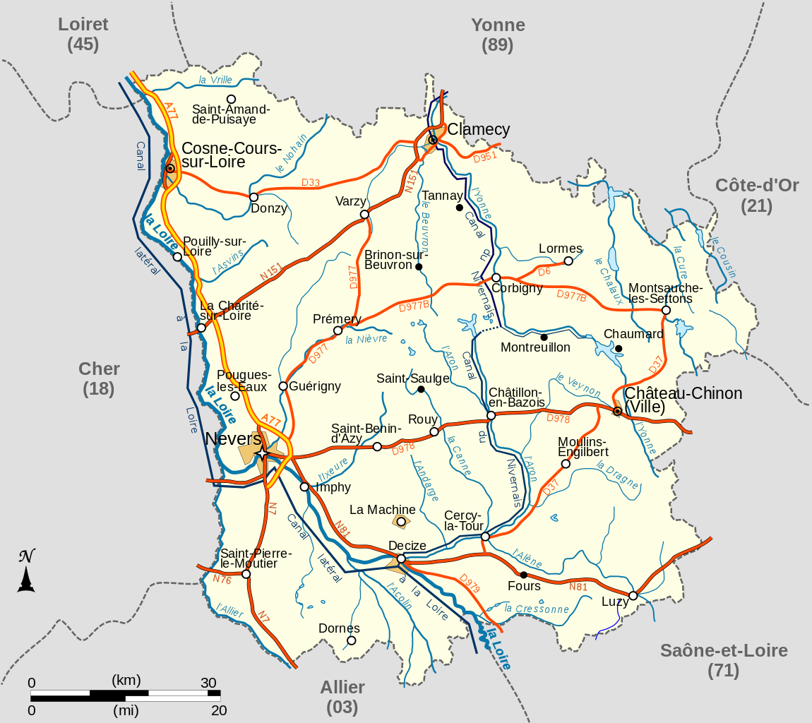
| Beschrijving | Carte du département français de la Nièvre avec réseau hydrographique et réseau routier principal |
| Datum | |
| Bron |
travail personnel
|
| Auteur | LeMorvandiau |
| Andere versies |
.svg)  |
Licentie
Ik, de auteursrechthebbende van dit werk, maak het hierbij onder de volgende licenties beschikbaar:

|
Toestemming wordt verleend voor het kopiëren, verspreiden en/of wijzigen van dit document onder de voorwaarden van de GNU-licentie voor vrije documentatie, versie 1.2 of enige latere versie als gepubliceerd door de Free Software Foundation; zonder Invariant Sections, zonder Front-Cover Texts, en zonder Back-Cover Texts. Een kopie van de licentie is opgenomen in de sectie GNU-licentie voor vrije documentatie. |
Dit bestand is gelicenseerd onder de Creative Commons-licenties Naamsvermelding-Gelijk delen 3.0 Unported, 2.5 Algemeen, 2.0 Algemeen en 1.0 Algemeen.
- De gebruiker mag:
- Delen – het werk kopiëren, verspreiden en doorgeven
- Remixen – afgeleide werken maken
- Onder de volgende voorwaarden:
- naamsvermelding – U moet op een gepaste manier aan naamsvermelding doen, een link naar de licentie geven, en aangeven of er wijzigingen in het werk zijn aangebracht. U mag dit op elke redelijke manier doen, maar niet zodanig dat de indruk wordt gewekt dat de licentiegever instemt met uw werk of uw gebruik van zijn werk.
- Gelijk delen – Als u het werk heeft geremixt, veranderd, of erop heeft voortgebouwd, moet u het gewijzigde materiaal verspreiden onder dezelfde licentie als het oorspronkelijke werk, of een daarmee compatibele licentie.
U mag zelf één van de licenties kiezen.
Bestandsgeschiedenis
Klik op een datum/tijd om het bestand te zien zoals het destijds was.
| Datum/tijd | Miniatuur | Afmetingen | Gebruiker | Opmerking | |
|---|---|---|---|---|---|
| huidige versie | 27 okt 2008 07:36 | | 898 × 800 (216 kB) | LeMorvandiau | Normalisation générale selon les conventions cartographiques. |
| 10 apr 2008 05:50 |  | 710 × 704 (204 kB) | LeMorvandiau | == Description == {{Information |Description=Carte du département français de la Nièvre avec réseau hydrographique et réseau routier principal |Source=travail personnel |Date=9 avril 2008 |Author= LeMorvandiau |Permission= |othe | |
| 10 apr 2008 05:45 |  | 710 × 704 (204 kB) | LeMorvandiau | == Description == {{Information |Description=Carte du département français de la Nièvre avec réseau hydrographique et réseau routier principal |Source=travail personnel |Date=9 avril 2008 |Author= LeMorvandiau |Permission= |othe | |
| 9 apr 2008 06:10 |  | 801 × 896 (205 kB) | LeMorvandiau | {{Information |Description=Carte du département français de la Nièvre, avec réseau hydrographique et réseau routier principal |Source=travail personnel |Date=9 avril 2008 |Author= LeMorvandiau |Permission= |other_versions= }} [ |
Bestandsgebruik
Dit bestand wordt op de volgende pagina gebruikt:
Globaal bestandsgebruik
De volgende andere wiki's gebruiken dit bestand:
- Gebruikt op bg.wikipedia.org
- Gebruikt op el.wikipedia.org
- Gebruikt op en.wikipedia.org
- Gebruikt op eo.wikipedia.org
- Gebruikt op es.wikipedia.org
- Gebruikt op fr.wikipedia.org
- Nièvre (département)
- Chaumard (Nièvre)
- Gien-sur-Cure
- Montsauche-les-Settons
- Lormes
- La Machine (Nièvre)
- Corbigny
- Chiddes (Nièvre)
- Fléty
- Larochemillay
- Luzy
- Millay
- Tazilly
- Château-Chinon (Campagne)
- Chevenon
- Cossaye
- Gouloux
- Lucenay-lès-Aix
- Saint-Saulge
- Beuvron (Yonne)
- Ixeure
- Canne (affluent de l'Aron)
- Réseau routier de la Nièvre
- Utilisateur:LeMorvandiau/Cartes
- Portail:Nièvre
- Portail:Nièvre/Transport
- Projet:Cartographie/Cartes standards/France
- Magny-Cours
- Vrille (rivière)
- Climat de la Nièvre
- Gebruikt op it.wikipedia.org
- Gebruikt op ja.wikipedia.org
- Gebruikt op mr.wikipedia.org
- Gebruikt op oc.wikipedia.org
Globaal gebruik van dit bestand bekijken.