
Bestand:Carte des barrières de séparation.svg

Afmetingen van deze voorvertoning van het type PNG van dit SVG-bestand: 800 × 410 pixels Andere resoluties: 320 × 164 pixels | 640 × 328 pixels | 1.024 × 525 pixels | 1.280 × 656 pixels | 2.560 × 1.313 pixels | 1.726 × 885 pixels.
Oorspronkelijk bestand (SVG-bestand, nominaal 1.726 × 885 pixels, bestandsgrootte: 1,38 MB)
| Dit is een bestand van Wikimedia Commons. Onderstaande beschrijving komt van de beschrijving van het bestand daar. |
Beschrijving
| Beschrijving |
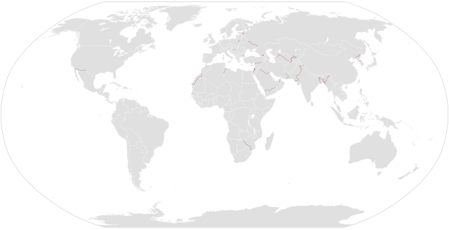
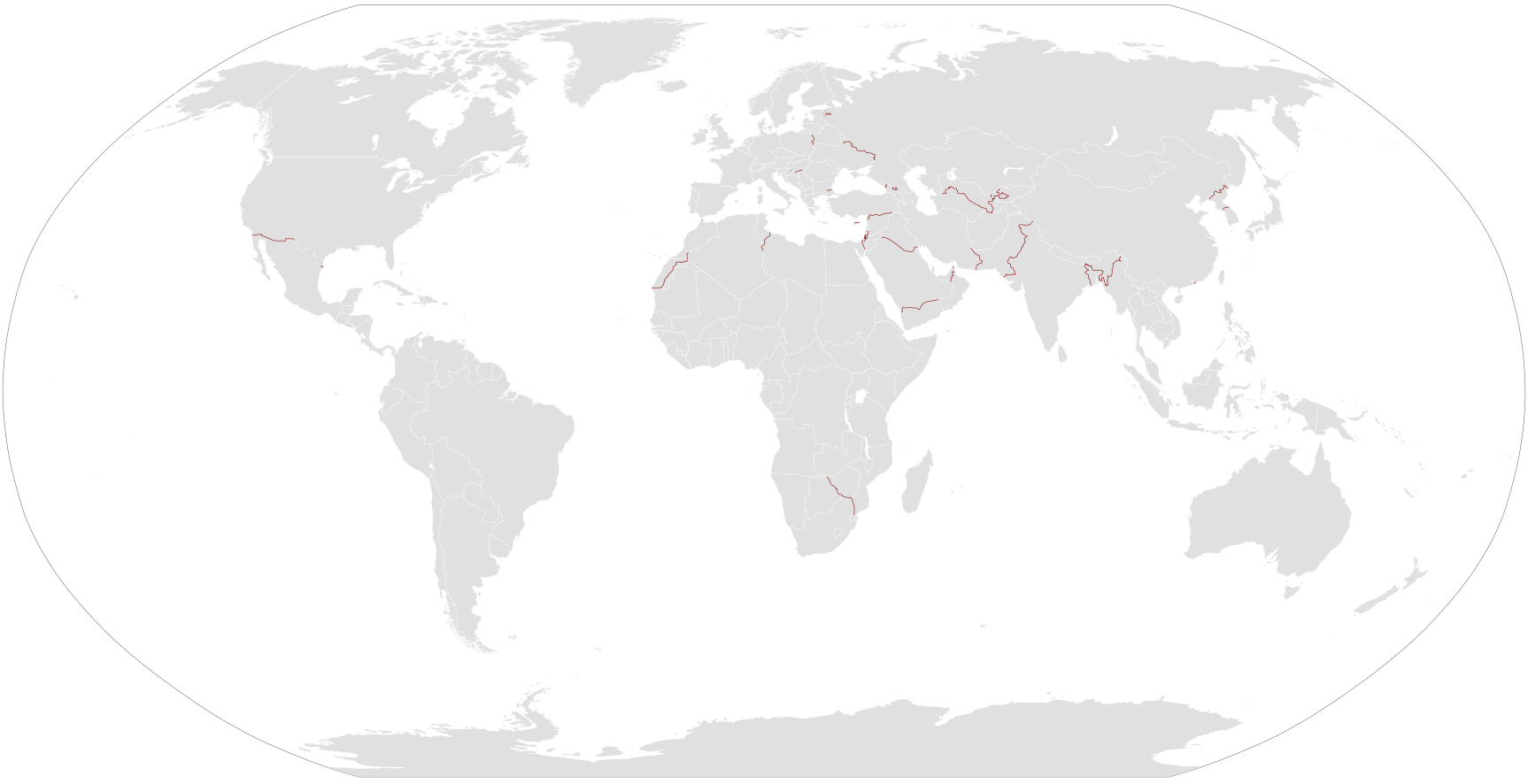
English: Map of separation barriers in the world. The exact status of many barriers is unknown (length completed, etc), but also the number of barriers. A separation barrier is not necessarily a border barrier
Français : Carte des barrières de séparation dans le monde. L'état exacte de plusieurs barrières est inconnue (proportion terminée, etc), mais aussi le nombre de barrières. |
| Datum | |
| Bron |
Multiple:
|
| Auteur | Eigen werk |
Licentie
| Ik, de auteursrechthebbende van dit werk, geef dit werk vrij in het publieke domein. Dit is wereldwijd van toepassing. In sommige landen is dit wettelijk niet mogelijk; in die gevallen geldt: Ik sta iedereen toe dit werk voor eender welk doel te gebruiken, zonder enige voorwaarden, tenzij zulke voorwaarden door de wet worden voorgeschreven. |
Bestandsgeschiedenis
Klik op een datum/tijd om het bestand te zien zoals het destijds was.
| Datum/tijd | Miniatuur | Afmetingen | Gebruiker | Opmerking | |
|---|---|---|---|---|---|
| huidige versie | 3 aug 2020 23:47 | | 1.726 × 885 (1,38 MB) | TheNavigatrr | Updated Estonia border with new completion date, per https://news.err.ee/974691/opinion-state-hinting-it-s-time-to-cut-corners-on-estonia-s-eastern-border Also made the pixel size larger so it can be seen and zoomed in. |
| 22 jul 2019 22:59 |  | 863 × 443 (1,39 MB) | TheNavigatrr | Corrected border barrier progress at the southeast part of the West Bank and the Israeli border with Lebanon, as well as correcting the shape of the Turkey-Syria barrier. | |
| 28 jan 2016 15:25 |  | 863 × 443 (1,39 MB) | Mapeh | Ajout Bulgarie-Turquie & Hongrie-Croatie | |
| 6 sep 2015 18:57 |  | 863 × 443 (1,27 MB) | Mapeh | Ajout de quelques barrières | |
| 10 jan 2014 13:30 |  | 863 × 443 (1,38 MB) | Mapeh | ajout de quelques barrières de plus | |
| 13 apr 2013 22:11 |  | 863 × 443 (1,37 MB) | Mapeh | {{Information |Description ={{en|1=Map of en:separation barriers in the world.}} {{fr|1=Carte des fr:barrières de séparation dans le monde.}} |Source =Multiple |Author ={{self}} |Date =2013-04-13 |Permission ... |
Bestandsgebruik
Dit bestand wordt op de volgende pagina gebruikt:
Globaal bestandsgebruik
De volgende andere wiki's gebruiken dit bestand:
- Gebruikt op ar.wikipedia.org
- Gebruikt op bg.wikipedia.org
- Gebruikt op de.wikipedia.org
- Gebruikt op en.wikipedia.org
- Gebruikt op fr.wikipedia.org
- Gebruikt op he.wikipedia.org
- Gebruikt op ht.wikipedia.org
- Gebruikt op it.wikipedia.org
- Gebruikt op ja.wikipedia.org
- Gebruikt op ko.wikipedia.org
- Gebruikt op pl.wikipedia.org
- Gebruikt op ru.wikipedia.org
- Gebruikt op uk.wikipedia.org
- Gebruikt op zh.wikipedia.org