
Bestand:Central-Eastern-Livingston-Map.png
Grootte van deze voorvertoning: 798 × 600 pixels. Andere resoluties: 320 × 240 pixels | 639 × 480 pixels | 1.022 × 768 pixels | 1.280 × 962 pixels | 2.560 × 1.924 pixels | 3.928 × 2.952 pixels.
Oorspronkelijk bestand (3.928 × 2.952 pixels, bestandsgrootte: 3,08 MB, MIME-type: image/png)
| Dit is een bestand van Wikimedia Commons. Onderstaande beschrijving komt van de beschrijving van het bestand daar. |
Beschrijving
| Beschrijving |
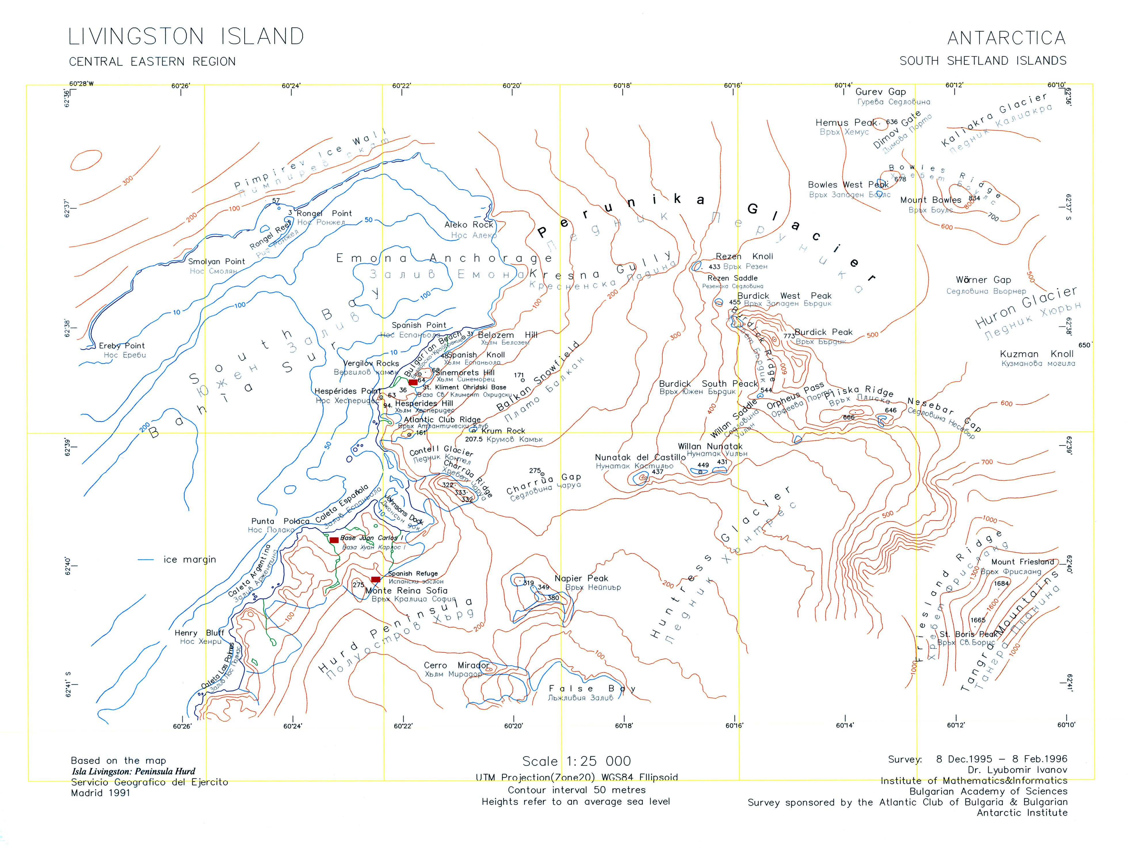
English: A version of the original 1996 map "L.L. Ivanov. Livingston Island: Central-Eastern Region. Scale 1:25000 topographic map. Sofia: Antarctic Place-names Commission of Bulgaria, 1996." uploaded by the author of that map who is also the CEO of the Antarctic Place-names Commission. |
| Datum | |
| Bron | Eigen werk |
| Auteur | Apcbg |
| Andere versies | File:Central-Eastern-Livingston-Map-1996.png |
Licentie
Ik, de auteursrechthebbende van dit werk, maak het hierbij onder de volgende licenties beschikbaar:
Dit bestand is gelicenseerd onder de Creative Commons-licentie Naamsvermelding-Gelijk delen 3.0 Unported
- De gebruiker mag:
- Delen – het werk kopiëren, verspreiden en doorgeven
- Remixen – afgeleide werken maken
- Onder de volgende voorwaarden:
- naamsvermelding – U moet op een gepaste manier aan naamsvermelding doen, een link naar de licentie geven, en aangeven of er wijzigingen in het werk zijn aangebracht. U mag dit op elke redelijke manier doen, maar niet zodanig dat de indruk wordt gewekt dat de licentiegever instemt met uw werk of uw gebruik van zijn werk.
- Gelijk delen – Als u het werk heeft geremixt, veranderd, of erop heeft voortgebouwd, moet u het gewijzigde materiaal verspreiden onder dezelfde licentie als het oorspronkelijke werk, of een daarmee compatibele licentie.

|
Toestemming wordt verleend voor het kopiëren, verspreiden en/of wijzigen van dit document onder de voorwaarden van de GNU-licentie voor vrije documentatie, versie 1.2 of enige latere versie als gepubliceerd door de Free Software Foundation; zonder Invariant Sections, zonder Front-Cover Texts, en zonder Back-Cover Texts. Een kopie van de licentie is opgenomen in de sectie GNU-licentie voor vrije documentatie. |
U mag zelf één van de licenties kiezen.
Bestandsgeschiedenis
Klik op een datum/tijd om het bestand te zien zoals het destijds was.
| Datum/tijd | Miniatuur | Afmetingen | Gebruiker | Opmerking | |
|---|---|---|---|---|---|
| huidige versie | 27 jul 2010 12:45 | | 3.928 × 2.952 (3,08 MB) | Apcbg | Minor fixes. |
| 27 jul 2010 10:47 |  | 3.928 × 2.952 (33,23 MB) | Apcbg | {{Information |Description={{en|1=A version of the original 1996 map ''L.L. Ivanov. Livingston Island: Central-Eastern Region. Scale 1:25000 topographic map. Sofia: Antarctic Place-names Commission of Bulgaria, 1996.'' uploaded by the author of that map. |
Bestandsgebruik
Dit bestand wordt op de volgende pagina gebruikt:
Globaal bestandsgebruik
De volgende andere wiki's gebruiken dit bestand:
- Gebruikt op ar.wikipedia.org
- Gebruikt op bg.wikipedia.org
- Gebruikt op en.wikipedia.org
- Aleko Point
- Atlantic Club Ridge
- Bowles West Peak
- Bulgarian Beach
- Charrúa Gap
- Dimov Gate
- Emona Anchorage
- Gurev Gap
- Hesperides Hill
- Kresna Gully
- Krum Rock
- Rezen Knoll
- Rezen Saddle
- Rongel Point
- Rongel Reef
- Sea Lion Glacier
- Sea Lion Tarn
- Sinemorets Hill
- Smolyan Point
- Spanish Knoll
- Spanish Point (Antarctica)
- St. Boris Peak
- Vergilov Rocks
- Willan Saddle
- Balkan Snowfield
- Belozem Hill
- Mount Friesland
- Willan Nunatak
- Contell Glacier
- Pimpirev Ice Wall
- Gebruikt op he.wikipedia.org
- Gebruikt op it.wikipedia.org
- Gebruikt op pt.wikipedia.org
Globaal gebruik van dit bestand bekijken.