
Bestand:China 1936.png
Geen hogere resolutie beschikbaar.
China_1936.png (120 × 131 pixels, bestandsgrootte: 13 kB, MIME-type: image/png)
| Dit is een bestand van Wikimedia Commons. Onderstaande beschrijving komt van de beschrijving van het bestand daar. |
Beschrijving
| Beschrijving |
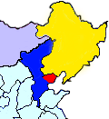
English: This map shows the territory controlled by the Hebei-Chahar Political Council (blue), the East Hebei Anti-Communist Autonomous Government (red), Manchukuo (yellow), and Mongolia (grey) at the end of 1935 and the beginning of 1936. As noted on Wikipedia, the Hebei-Chahar Political Council controlled the provinces of Chahar and Hebei except for the portion of Hebei Province occuped by the East Hebei Anti-Communist Autonomous Government, which, as noted by Paul French in The Old Shanghai A-Z and other sources, controlled the 22 northeastern counties of Hebei Province running along the Great Wall and south into the demilitarized zone almost as far south as Beijing and Tianjin.
Although this is a crude map based off "File:ROC-Chahar.png", there are several articles in severe need of some sort of geographic illustration, |
| Datum | |
| Bron | Eigen werk |
| Auteur | CurtisNaito |
Licentie
Ik, de auteursrechthebbende van dit werk, maak het hierbij onder de volgende licentie beschikbaar:
Dit bestand is gelicenseerd onder de Creative Commons-licentie Naamsvermelding-Gelijk delen 3.0 Unported
- De gebruiker mag:
- Delen – het werk kopiëren, verspreiden en doorgeven
- Remixen – afgeleide werken maken
- Onder de volgende voorwaarden:
- naamsvermelding – U moet op een gepaste manier aan naamsvermelding doen, een link naar de licentie geven, en aangeven of er wijzigingen in het werk zijn aangebracht. U mag dit op elke redelijke manier doen, maar niet zodanig dat de indruk wordt gewekt dat de licentiegever instemt met uw werk of uw gebruik van zijn werk.
- Gelijk delen – Als u het werk heeft geremixt, veranderd, of erop heeft voortgebouwd, moet u het gewijzigde materiaal verspreiden onder dezelfde licentie als het oorspronkelijke werk, of een daarmee compatibele licentie.
Bestandsgeschiedenis
Klik op een datum/tijd om het bestand te zien zoals het destijds was.
| Datum/tijd | Miniatuur | Afmetingen | Gebruiker | Opmerking | |
|---|---|---|---|---|---|
| huidige versie | 19 okt 2012 01:27 | | 120 × 131 (13 kB) | CurtisNaito | User created page with UploadWizard |
Bestandsgebruik
Dit bestand wordt op de volgende 2 pagina's gebruikt:
Globaal bestandsgebruik
De volgende andere wiki's gebruiken dit bestand:
- Gebruikt op en.wikipedia.org
- Gebruikt op es.wikipedia.org
- Gebruikt op ja.wikipedia.org
- Gebruikt op ko.wikipedia.org
- Gebruikt op uk.wikipedia.org
- Gebruikt op www.wikidata.org
- Gebruikt op zh.wikipedia.org