
Bestand:Conquista Hispania.svg

Afmetingen van deze voorvertoning van het type PNG van dit SVG-bestand: 800 × 547 pixels Andere resoluties: 320 × 219 pixels | 640 × 438 pixels | 1.024 × 701 pixels | 1.280 × 876 pixels | 2.560 × 1.752 pixels | 950 × 650 pixels.
Oorspronkelijk bestand (SVG-bestand, nominaal 950 × 650 pixels, bestandsgrootte: 1,07 MB)
| Dit is een bestand van Wikimedia Commons. Onderstaande beschrijving komt van de beschrijving van het bestand daar. |
Beschrijving
| Beschrijving |
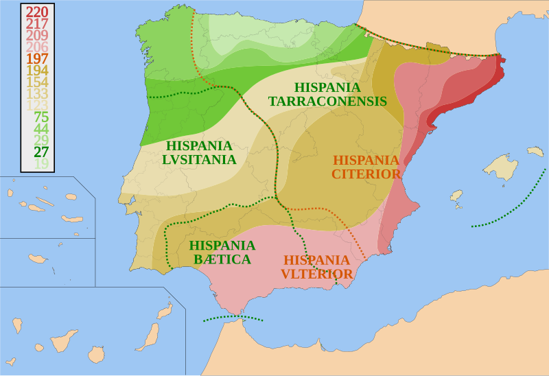
Español: Mapa de España y Portugal sobre la conquista de Hispania desde 220 a.C. a 19 a.C. y sus fronteras provinciales. Basado en otros mapas, los avances territoriales y fronteras provinciales son orientativos.
Català: Mapa d'Espanya i Portugal sobre la conquesta d'Hispania, des del 220 a.C. fins el 19 a.C. amb les fronteres provincials. És basat en altres mapes. Els avenços territorials i fronteres provincials són orientatius.
English: Map of Spain and Portugal showing the conquest of Hispania from 220 B.C. to 19 B.C. and provincial borders. It is based on other maps; the territorial advances and provincial borders are illustrative. |
| Datum | |
| Bron | Eigen werk |
| Auteur | HansenBCN |
Licentie
I, HansenBCN, de auteursrechthebbende van dit werk, maakt het hierbij onder de volgende licenties beschikbaar:

|
Toestemming wordt verleend voor het kopiëren, verspreiden en/of wijzigen van dit document onder de voorwaarden van de GNU-licentie voor vrije documentatie, versie 1.2 of enige latere versie als gepubliceerd door de Free Software Foundation; zonder Invariant Sections, zonder Front-Cover Texts, en zonder Back-Cover Texts. Een kopie van de licentie is opgenomen in de sectie GNU-licentie voor vrije documentatie. |
| Dit bestand is gelicenseerd onder de Creative Commons-licentie Naamsvermelding-Gelijk delen 3.0 Unported | ||
| Naamsvermelding: I, HansenBCN | ||
| ||
| Deze licentietag is toegevoegd aan dit bestand in verband met de GFDL licentie-update. |
U mag zelf één van de licenties kiezen.
Bestandsgeschiedenis
Klik op een datum/tijd om het bestand te zien zoals het destijds was.
| Datum/tijd | Miniatuur | Afmetingen | Gebruiker | Opmerking | |
|---|---|---|---|---|---|
| huidige versie | 31 jul 2007 21:46 | | 950 × 650 (1,07 MB) | HansenBCN | {{Information |Description= {{es|Mapa de España y Portugal sobre la conquista de Hispania desde 220 AEC a 19 AEC y sus fronteras provinciales.}} |Source=self-made |Date= July 31, 2007 |Author= HansenBCN }} [[Category:Maps of Roman Hisp |
Bestandsgebruik
Dit bestand wordt op de volgende pagina gebruikt:
Globaal bestandsgebruik
De volgende andere wiki's gebruiken dit bestand:
- Gebruikt op an.wikipedia.org
- Gebruikt op ar.wikipedia.org
- Gebruikt op ast.wikipedia.org
- Gebruikt op azb.wikipedia.org
- Gebruikt op az.wikipedia.org
- Gebruikt op bg.wikipedia.org
- Gebruikt op br.wikipedia.org
- Gebruikt op ca.wikipedia.org
- Gebruikt op ckb.wikipedia.org
- Gebruikt op cs.wikipedia.org
- Gebruikt op da.wikipedia.org
- Gebruikt op de.wikipedia.org
- Gebruikt op el.wikipedia.org
- Gebruikt op en.wikipedia.org
- Iberian Peninsula
- Lusitania
- History of Portugal
- 309
- Military history of Portugal
- Tarraco
- Portal:Portugal
- List of revolutions and rebellions
- Roman conquest of the Iberian Peninsula
- Northeastern Iberian script
- Hispania
- Ancient Carthage
- Warfare in the ancient Iberian Peninsula
- User:Amir.Vector
- User:Falcaorib
- Iberian revolt
- Gebruikt op es.wikipedia.org
Globaal gebruik van dit bestand bekijken.