
Bestand:Dersim districts.png
Grootte van deze voorvertoning: 776 × 600 pixels. Andere resoluties: 311 × 240 pixels | 621 × 480 pixels | 994 × 768 pixels | 1.056 × 816 pixels.
Oorspronkelijk bestand (1.056 × 816 pixels, bestandsgrootte: 30 kB, MIME-type: image/png)
| Dit is een bestand van Wikimedia Commons. Onderstaande beschrijving komt van de beschrijving van het bestand daar. |
Beschrijving
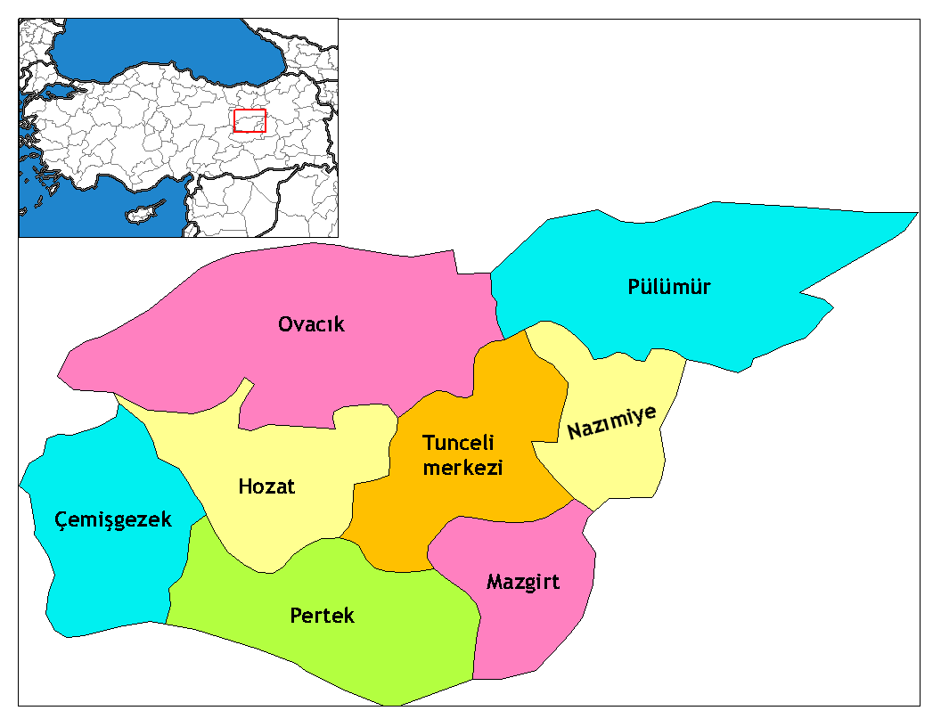
| Beschrijving | Map of the districts of Tunceli province in Turkey. Created by Rarelibra 17:52, 4 December 2006 (UTC) for public domain use, using MapInfo Professional v8.5 and various mapping resources. Edited by One Homo Sapiens Corrected text where İ,Ş,ı,ğ,or ş occurs in name. Source: [statoids-com]. Increased font size and enhanced color differences among adjacent districts. |
| Datum | 4 december 2006 (originele uploaddatum) |
| Bron | Geen machineleesbare bron opgegeven. Eigen werk aangenomen (gebaseerd op auteursrechtclaims). |
| Auteur | Geen machineleesbare auteur aanwezig. Op basis van auteursrechtclaims wordt auteur Rarelibra aangenomen. |
Licentie
| Ik, de auteursrechthebbende van dit werk, geef dit werk vrij in het publieke domein. Dit is wereldwijd van toepassing. In sommige landen is dit wettelijk niet mogelijk; in die gevallen geldt: Ik sta iedereen toe dit werk voor eender welk doel te gebruiken, zonder enige voorwaarden, tenzij zulke voorwaarden door de wet worden voorgeschreven. |
Bestandsgeschiedenis
Klik op een datum/tijd om het bestand te zien zoals het destijds was.
| Datum/tijd | Miniatuur | Afmetingen | Gebruiker | Opmerking | |
|---|---|---|---|---|---|
| huidige versie | 8 jun 2014 13:39 | | 1.056 × 816 (30 kB) | Semsûrî | Changed the name |
| 29 dec 2008 04:50 |  | 1.056 × 816 (30 kB) | One Homo Sapiens | Corrected text where İ,Ş,ı,ğ,or ş occurs in name. Source: [statoids-com]. Increased font size and enhanced color differences among adjacent districts. | |
| 4 dec 2006 19:52 |  | 1.056 × 816 (30 kB) | Rarelibra | Map of the districts of Tunceli province in Turkey. Created by ~~~~ for public domain use, using MapInfo Professional v8.5 and various mapping resources. |
Bestandsgebruik
Dit bestand wordt op de volgende 9 pagina's gebruikt:
Globaal bestandsgebruik
De volgende andere wiki's gebruiken dit bestand:
- Gebruikt op ar.wikipedia.org
- Gebruikt op arz.wikipedia.org
- Gebruikt op ast.wikipedia.org
- Gebruikt op az.wikipedia.org
- Gebruikt op ca.wikipedia.org
- Gebruikt op ceb.wikipedia.org
- Gebruikt op cs.wikipedia.org
- Gebruikt op de.wikipedia.org
- Tunceli
- Mazgirt
- Nazımiye
- Hozat
- Pertek
- Pülümür
- Ovacık (Tunceli)
- Çemişgezek
- Vorlage:Navigationsleiste Landkreise der Provinz Tunceli
- Akdemir (Pertek)
- Aşağıgülbahçe
- Elmakaşı
- Yenisöğüt
- Yaylagünü
- Yarımkaya
- Yakatarla
- Tatuşağı
- Paşadüzü
- Öveçler
- Mollaaliler
- Kozluca
- Koyungölü
- Konaklar (Ovacık)
- Havuzlu
- Güneykonak
- Gözeler
- Eskigedik
- Çöğürlük
- Çemberlitaş
- Çakmaklı
- Büyükköy (Ovacık)
- Aşağıtorunoba
- Arslandoğmuş
- Akyayık
- Yukarıyakabaşı
- Yeniköy (Pertek)
- Tozkoparan
- Pirinççi
- Pınarlar (Pertek)
- Konurat
- Koçpınar
- Karagüney
Globaal gebruik van dit bestand bekijken.