
Bestand:Desceliers 1550 map - detail showing Arenes.jpg
Geen hogere resolutie beschikbaar.
Desceliers_1550_map_-_detail_showing_Arenes.jpg (450 × 450 pixels, bestandsgrootte: 30 kB, MIME-type: image/jpeg)
| Dit is een bestand van Wikimedia Commons. Onderstaande beschrijving komt van de beschrijving van het bestand daar. |
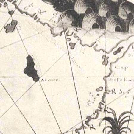
| Beschrijving | This is a detail from a 1550 world map by Pierre Desceliers, showing an island labelled Arenes. In 1895, George Collingridge argued that this word is a corruption of Abrolhos, and that the island therefore represents the Houtman Abrolhos; thus the map was recruited as evidence for the argument that the Houtman Abrolhos was first discovered by the Portuguese. This claim was mocked by Jan Heeres, however, and subsequently dismissed by James Sykes Battye. It is no longer maintained by any modern scholar. | |||||
| Datum | ||||||
| Bron | Cropped from a scan of an 1898 facsimile of this detail, taken from the British Museum's copy of the original map. Access to the scan is available on the National Library of Australia's website, at http://nla.gov.au/nla.map-rm2057-5. The graphical user interface provided does not support downloading the full image at full resolution, but the back end can be cajoled to do so by manually editing the CGI arguments in the URL. | |||||
| Auteur | Pierre Desceliers | |||||
| Toestemming (Hergebruik van dit bestand) |
|
|||||
| Andere versies | A detail showing the entire land mass said by some to be Australia, is available at Image:Desceliers 1550 map - Australia detail.jpg. | |||||
Bestandsgeschiedenis
Klik op een datum/tijd om het bestand te zien zoals het destijds was.
| Datum/tijd | Miniatuur | Afmetingen | Gebruiker | Opmerking | |
|---|---|---|---|---|---|
| huidige versie | 2 mei 2008 03:07 | | 450 × 450 (30 kB) | Hesperian | colour balanced |
| 20 feb 2008 14:53 |  | 450 × 450 (25 kB) | Hesperian | {{Information |Description=This is a detail from a 1550 world map by Pierre Desceliers, showing an island labelled ''Arenes''. In 1895, George Collingridge argued that this word is a corruption of ''Abrolhos'', and that the island therefore repres |
Bestandsgebruik
Dit bestand wordt op de volgende pagina gebruikt:
Globaal bestandsgebruik
De volgende andere wiki's gebruiken dit bestand:
- Gebruikt op en.wikipedia.org