
Bestand:Djibouti districts.png

Grootte van deze voorvertoning: 800 × 548 pixels. Andere resoluties: 320 × 219 pixels | 640 × 439 pixels | 1.024 × 702 pixels | 1.281 × 878 pixels.
Oorspronkelijk bestand (1.281 × 878 pixels, bestandsgrootte: 24 kB, MIME-type: image/png)
| Dit is een bestand van Wikimedia Commons. Onderstaande beschrijving komt van de beschrijving van het bestand daar. |
Beschrijving
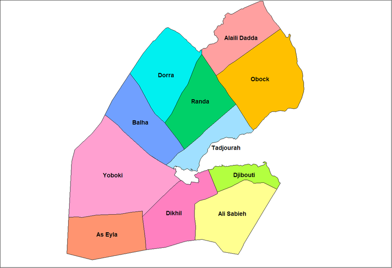
| Beschrijving | Map of the districts of Djibouti. Created by Rarelibra 17:00, 11 April 2007 (UTC) for public domain use, using MapInfo Professional v8.5 and various mapping resources. Source boundary map: http://reliefweb.int/sites/reliefweb.int/files/resources/3877CFE7144E9E65C1256F2D0048049E-djib_afpop0802.pdf |
| Datum | 11 april 2007 (originele uploaddatum) |
| Bron | Geen machineleesbare bron opgegeven. Eigen werk aangenomen (gebaseerd op auteursrechtclaims). |
| Auteur | Geen machineleesbare auteur aanwezig. Op basis van auteursrechtclaims wordt auteur Rarelibra aangenomen. |
Licentie
| Ik, de auteursrechthebbende van dit werk, geef dit werk vrij in het publieke domein. Dit is wereldwijd van toepassing. In sommige landen is dit wettelijk niet mogelijk; in die gevallen geldt: Ik sta iedereen toe dit werk voor eender welk doel te gebruiken, zonder enige voorwaarden, tenzij zulke voorwaarden door de wet worden voorgeschreven. |
Bestandsgeschiedenis
Klik op een datum/tijd om het bestand te zien zoals het destijds was.
| Datum/tijd | Miniatuur | Afmetingen | Gebruiker | Opmerking | |
|---|---|---|---|---|---|
| huidige versie | 11 apr 2007 19:00 | | 1.281 × 878 (24 kB) | Rarelibra | Map of the districts of Djibouti. Created by ~~~~ for public domain use, using MapInfo Professional v8.5 and various mapping resources. |
Bestandsgebruik
Dit bestand wordt op de volgende pagina gebruikt:
Globaal bestandsgebruik
De volgende andere wiki's gebruiken dit bestand:
- Gebruikt op ca.wikipedia.org
- Gebruikt op el.wikipedia.org
- Gebruikt op es.wikipedia.org
- Gebruikt op la.wikipedia.org
- Gebruikt op mt.wikipedia.org
- Gebruikt op no.wikipedia.org
- Gebruikt op pt.wikipedia.org
- Gebruikt op ro.wikipedia.org
- Gebruikt op sv.wikipedia.org
- Gebruikt op tr.wikipedia.org
- Gebruikt op www.wikidata.org