
Bestand:Drawehn.png
Grootte van deze voorvertoning: 511 × 599 pixels. Andere resoluties: 205 × 240 pixels | 409 × 480 pixels | 775 × 909 pixels.
Oorspronkelijk bestand (775 × 909 pixels, bestandsgrootte: 76 kB, MIME-type: image/png)
| Dit is een bestand van Wikimedia Commons. Onderstaande beschrijving komt van de beschrijving van het bestand daar. |
| Beschrijving |
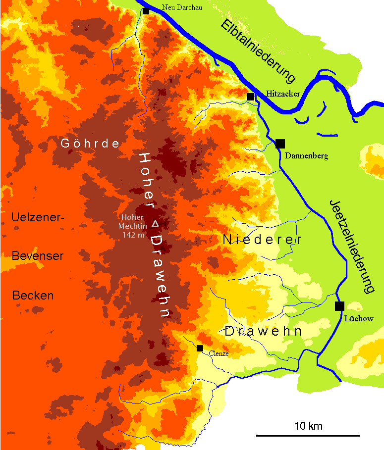
English: Map of the hilly region "Drawehn" between Hamburg and Berlin (North German Lowland). Map has a German inscription.
Deutsch: Karte des Drawehn mit Hervorhebung von Höhenschichten (geomorphologisches Profil). Die hellgrüne Farbe z. B. markiert Bereiche unter 20 m NN, orange-rot Bereiche zwischen 50 und 75 m, dunkelbraun über 100 m NN. Nur niedersächsische Gebiete sind dargestellt.
< 20 m NN
50–75 m NN
> 100 m NN |
| Datum | |
| Bron | Eigen werk. |
| Auteur | Christian Fischer |
Dit bestand is gelicenseerd onder de Creative Commons-licentie Naamsvermelding-Gelijk delen 3.0 Unported
Naamsvermelding: Christian Fischer
- De gebruiker mag:
- Delen – het werk kopiëren, verspreiden en doorgeven
- Remixen – afgeleide werken maken
- Onder de volgende voorwaarden:
- naamsvermelding – U moet op een gepaste manier aan naamsvermelding doen, een link naar de licentie geven, en aangeven of er wijzigingen in het werk zijn aangebracht. U mag dit op elke redelijke manier doen, maar niet zodanig dat de indruk wordt gewekt dat de licentiegever instemt met uw werk of uw gebruik van zijn werk.
- Gelijk delen – Als u het werk heeft geremixt, veranderd, of erop heeft voortgebouwd, moet u het gewijzigde materiaal verspreiden onder dezelfde licentie als het oorspronkelijke werk, of een daarmee compatibele licentie.
Bestandsgeschiedenis
Klik op een datum/tijd om het bestand te zien zoals het destijds was.
| Datum/tijd | Miniatuur | Afmetingen | Gebruiker | Opmerking | |
|---|---|---|---|---|---|
| huidige versie | 30 aug 2007 22:11 | | 775 × 909 (76 kB) | Fice | {{Information| |Description= '''''English:''''' Map of the hilly region "Drawehn" between Hamburg and Berlin (North German Lowland). Map has a German inscription. '''''Deutsch:''''' Karte des Drawehn mit Hervorhebung von Höhenschichten (geomorpholog |
Bestandsgebruik
Dit bestand wordt op de volgende pagina gebruikt:
Globaal bestandsgebruik
De volgende andere wiki's gebruiken dit bestand:
- Gebruikt op bg.wikipedia.org
- Gebruikt op cs.wikipedia.org
- Gebruikt op de.wikipedia.org
- Gebruikt op en.wikipedia.org
- Gebruikt op et.wikipedia.org
- Gebruikt op hsb.wikipedia.org
- Gebruikt op pl.wikipedia.org
- Gebruikt op uk.wikipedia.org