
Bestand:EasternSolomonsChart.jpg
Grootte van deze voorvertoning: 559 × 599 pixels. Andere resoluties: 224 × 240 pixels | 448 × 480 pixels | 640 × 686 pixels.
Oorspronkelijk bestand (640 × 686 pixels, bestandsgrootte: 90 kB, MIME-type: image/jpeg)
| Dit is een bestand van Wikimedia Commons. Onderstaande beschrijving komt van de beschrijving van het bestand daar. |
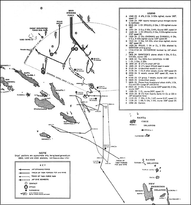
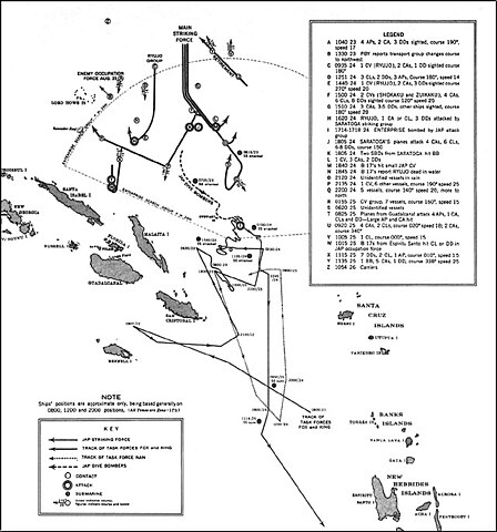
| Beschrijving | US Navy map of The Battle of the Eastern Solomons. Tracks of Allied (U.S.) forces are most likely fairly accurate. Tracks of Japanese forces are approximate and/or conjectured. The term "Jap" is used as shorthand for "Japanese" on the map. It's unknown whether this was used pejoratively in this publication or as an accepted abbreviation at that time. |
| Datum | |
| Bron | US Government ( http://www.ibiblio.org/hyperwar/USN/USN-CN-ESols/index.html )The Battle of the Eastern Solomons, 23-25 August 1942, Navy Department Office of Naval Intelligence, Combat Narrative |
| Auteur | US Government |
| Toestemming (Hergebruik van dit bestand) |
US Government/public domain |
Dit bestand is een werk van een zeeman of beambte van de U.S. Navy, gemaakt tijdens diens officiële werkzaamheden. Aangezien het een werk van de Amerikaanse federale overheid betreft, bevindt deze afbeelding zich in het publiek domein.
|
 | |
| Van dit bestand is vastgesteld dat er geen bekende auteursrechtaanspraken op rusten, alle aanverwante en naburige rechten daarbij inbegrepen. | ||
Bestandsgeschiedenis
Klik op een datum/tijd om het bestand te zien zoals het destijds was.
| Datum/tijd | Miniatuur | Afmetingen | Gebruiker | Opmerking | |
|---|---|---|---|---|---|
| huidige versie | 24 mei 2006 18:12 | | 640 × 686 (90 kB) | Cla68 | {{Information| |Description= US Navy map of The Battle of the Eastern Solomons. This map may not be entirely accurate since it was published before World War II was over. |Source= US Government (http://www.ibiblio.org/hyperwar/USN/USN-CN-ESols/index.html |
Bestandsgebruik
Dit bestand wordt op de volgende pagina gebruikt:
Globaal bestandsgebruik
De volgende andere wiki's gebruiken dit bestand:
- Gebruikt op azb.wikipedia.org
- Gebruikt op cs.wikipedia.org
- Gebruikt op da.wikipedia.org
- Gebruikt op en.wikipedia.org
- Gebruikt op es.wikipedia.org
- Gebruikt op fr.wikipedia.org
- Gebruikt op he.wikipedia.org
- Gebruikt op hu.wikipedia.org
- Gebruikt op id.wikipedia.org
- Gebruikt op ko.wikipedia.org
- Gebruikt op sr.wikipedia.org
- Gebruikt op vi.wikipedia.org
- Gebruikt op zh.wikipedia.org