
Bestand:Europe 1748-1766 en.png

Grootte van deze voorvertoning: 800 × 570 pixels. Andere resoluties: 320 × 228 pixels | 640 × 456 pixels | 1.024 × 730 pixels | 1.280 × 913 pixels | 2.560 × 1.825 pixels | 3.872 × 2.761 pixels.
Oorspronkelijk bestand (3.872 × 2.761 pixels, bestandsgrootte: 1,26 MB, MIME-type: image/png)
| Dit is een bestand van Wikimedia Commons. Onderstaande beschrijving komt van de beschrijving van het bestand daar. |

|
Deze map of europe-afbeelding zou opnieuw moeten worden aangemaakt als een SVG-bestand door vectorafbeeldingen te gebruiken. Dit heeft een aantal voordelen; zie Commons:Media for cleanup voor meer informatie. Als er een SVG-formaat van deze afbeelding bestaat, dan deze graag uploaden. Nadat u dit heeft gedaan, gelieve dit sjabloon te vervangen door het sjabloon {{vector version available|nieuwe bestandsnaam.svg}} op deze afbeeldingspagina.
|
_en.png)
.png)
.jpg)
Beschrijving
| Beschrijving |
Deutsch: Diese Karte zeigt Europa in den Jahren nach dem Frieden von Aachen 1748 und in der Zeit des Siebenjährigen Krieges (1756-1763). Bis 1766 kam es zu keinen größeren geographischen Veränderungen in Europa.
Die Arbeit wurde mit Inkscape erstellt und beruht hauptsächlich auf einer Karte in: Putzger - Historischer Weltatlas, Berlin 1990, S.78f.
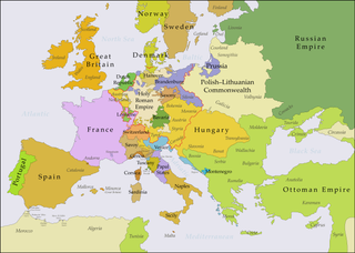
English: This map shows Europe in the years after the Treaty of Aix-la-Chapelle 1748 and the Seven Years' War (1756-1763). Europe did not see another major geographical change until 1766. The red line marks the borders of the Holy Roman Empire.
The work was created with Inkscape and is mainly based on a map in: Putzger - Historischer Weltatlas, Berlin 1990, 78 pp.
Français : Cette carte montre l'Europe dans les années après le Traité d'Aix-la-Chapelle (1748) et pendant les années de la Guerre des Sept Ans (1756-1763). L'Europe n'a pas vu un autre changement géographique important jusqu'à 1766.
Le travail a été créé avec Inkscape et il est basé principalement sur une carte dans: Putzger - Historischer Weltatlas, Berlin 1990, 78 pp.
Polski: Ta mapa ukazuje Europę w latach po pokoju w Akwizgranie z 1748 i wojnie siedmioletniej (1756-1763). Europa nie uświadczyła żadnych poważniejszych zmian geograficznych aż do 1766. Czerwona linia znaczy granice Świętego Cesarstwa Rzymskiego.
Praca została stworzona z użyciem Inkscape i powstała głównie na bazie mapy w: Putzger - Historischer Weltatlas, Berlin 1990, 78 pp.
Русский: Эта карта представляет Европу после заключения Аахенского мира в 1748 г. и во время Семилетней войны (1756-1763 гг.). До 1766 г. эта картина Европы не исменилась.
Эта работа нарисована с помощью программы Inkscape и основана на карте из книги: Putzger - Historischer Weltatlas, Berlin 1990, 78 cc. |
| Datum | |
| Bron |
Dit bestand is afgeleid van: Europe 1748-1766.png |
| Auteur | P. S. Burton |
Licentie
Ik, de auteursrechthebbende van dit werk, maak het hierbij onder de volgende licentie beschikbaar:
Dit bestand is gelicenseerd onder de Creative Commons-licentie Naamsvermelding 3.0 Unported
- De gebruiker mag:
- Delen – het werk kopiëren, verspreiden en doorgeven
- Remixen – afgeleide werken maken
- Onder de volgende voorwaarden:
- naamsvermelding – U moet op een gepaste manier aan naamsvermelding doen, een link naar de licentie geven, en aangeven of er wijzigingen in het werk zijn aangebracht. U mag dit op elke redelijke manier doen, maar niet zodanig dat de indruk wordt gewekt dat de licentiegever instemt met uw werk of uw gebruik van zijn werk.
Bestandsgeschiedenis
Klik op een datum/tijd om het bestand te zien zoals het destijds was.
| Datum/tijd | Miniatuur | Afmetingen | Gebruiker | Opmerking | |
|---|---|---|---|---|---|
| huidige versie | 15 jul 2018 23:48 | | 3.872 × 2.761 (1,26 MB) | Bryanrutherford0 | Added the Ionian Islands, made the Duchy of Milan a Habsburg possession |
| 10 jul 2018 04:29 |  | 3.872 × 2.761 (1,25 MB) | Bryanrutherford0 | Added Comtat Venaissin and redrew borders of Neuchâtel, Bishopric Basel, and Montbéliard | |
| 5 okt 2017 15:19 |  | 3.872 × 2.761 (1,25 MB) | Bryanrutherford0 | Adjusted Russian-Swedish border in Finland to reflect Russian gains in the 1743 Treaty of Åbo after the Russo-Swedish War. | |
| 3 okt 2017 02:40 |  | 3.872 × 2.761 (1,25 MB) | Bryanrutherford0 | Transferred control of Saaremaa and Hiiumaa to Russia (1721 Treaty of Nystad) | |
| 30 sep 2017 16:58 |  | 3.872 × 2.761 (1,25 MB) | Bryanrutherford0 | Adjusted Russian-Swedish border in Finland to reflect Russian gains in the 1743 Treaty of Åbo after the Russo-Swedish War. | |
| 2 feb 2017 22:49 |  | 3.872 × 2.761 (1,26 MB) | Blowwhite1 | Fixed names | |
| 5 mei 2013 10:01 |  | 3.872 × 2.761 (1,25 MB) | P. S. Burton | == {{int:filedesc}} == {{Information |Description={{de|1=Diese Karte zeigt Europa in den Jahren nach dem Frieden von Aachen 1748 und in der Zeit des Siebenjährigen Krieges (1756-1763). Bi... |
Bestandsgebruik
Dit bestand wordt op de volgende pagina gebruikt:
Globaal bestandsgebruik
De volgende andere wiki's gebruiken dit bestand:
- Gebruikt op af.wikipedia.org
- Gebruikt op ar.wikipedia.org
- Gebruikt op azb.wikipedia.org
- Gebruikt op bg.wikipedia.org
- Gebruikt op cs.wikipedia.org
- Gebruikt op de.wikipedia.org
- Gebruikt op el.wikipedia.org
- Gebruikt op en.wikipedia.org
- War of the Austrian Succession
- Louis XV
- Silesian Wars
- Russo-Turkish War (1768–1774)
- Battle of Leuthen
- Comtat Venaissin
- Second Silesian War
- History of the Russo-Turkish wars
- French–Habsburg rivalry
- Seven Years' War
- Anglo-Austrian Alliance
- Third Silesian War
- International relations (1648–1814)
- User:Falcaorib/Europe
- Gebruikt op es.wikipedia.org
- Gebruikt op et.wikipedia.org
- Gebruikt op eu.wikipedia.org
- Gebruikt op fa.wikipedia.org
- Gebruikt op fi.wikipedia.org
- Gebruikt op fr.wikipedia.org
- Gebruikt op he.wikipedia.org
- Gebruikt op hu.wikipedia.org
- Gebruikt op hy.wikipedia.org
- Gebruikt op id.wikipedia.org
- Gebruikt op it.wikipedia.org
- Gebruikt op it.wikiversity.org
- Gebruikt op ja.wikipedia.org
Globaal gebruik van dit bestand bekijken.