
Bestand:Fertility rate world map 2.png

Grootte van deze voorvertoning: 800 × 410 pixels. Andere resoluties: 320 × 164 pixels | 864 × 443 pixels.
Oorspronkelijk bestand (864 × 443 pixels, bestandsgrootte: 113 kB, MIME-type: image/png)
| Dit is een bestand van Wikimedia Commons. Onderstaande beschrijving komt van de beschrijving van het bestand daar. |

|
Bestand:Total Fertility Rate Map by Country.svg is een vectorversie van dit bestand. Indien niet van slechtere kwaliteit dient deze gebruikt te worden in plaats van deze rasterafbeelding.
File:Fertility rate world map 2.png → File:Total Fertility Rate Map by Country.svg
Zie Help:SVG voor meer informatie. |
 |
Beschrijving
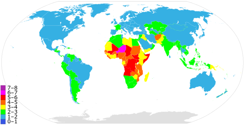
A more precise world map of country fertility rates, as listed at w:List of countries and territories by fertility rate. Note that this version is using outdated data; newer figures (e.g. 2015) are available
See also: Image:Fertility rate world map.PNG from 2006.
Licentie
| Ik, de auteursrechthebbende van dit werk, geef dit werk vrij in het publieke domein. Dit is wereldwijd van toepassing. In sommige landen is dit wettelijk niet mogelijk; in die gevallen geldt: Ik sta iedereen toe dit werk voor eender welk doel te gebruiken, zonder enige voorwaarden, tenzij zulke voorwaarden door de wet worden voorgeschreven. |
Bestandsgeschiedenis
Klik op een datum/tijd om het bestand te zien zoals het destijds was.
| Datum/tijd | Miniatuur | Afmetingen | Gebruiker | Opmerking | |
|---|---|---|---|---|---|
| huidige versie | 23 apr 2022 23:49 | | 864 × 443 (113 kB) | Innab | Updated with new 2020 data from CIA Factbook: https://www.cia.gov/the-world-factbook/field/total-fertility-rate/country-comparison#:~:text=Total%20fertility%20rate%20(TFR)%20compares,fertility%20rate%20at%20each%20age. |
| 12 feb 2020 08:05 |  | 864 × 443 (113 kB) | Innab | Updated with new 2020 data from CIA Factbook: https://www.cia.gov/library/publications/the-world-factbook/fields/356rank.html | |
| 2 dec 2018 21:59 |  | 856 × 435 (117 kB) | Innab | Updated old 2006 version with new 2018 version | |
| 17 jun 2006 05:31 |  | 1.357 × 628 (40 kB) | PlatypeanArchcow | A more precise world map of country fertility rates, as listed at w:List of countries and territories by fertility rate. |
Bestandsgebruik
Dit bestand wordt op de volgende pagina gebruikt:
Globaal bestandsgebruik
De volgende andere wiki's gebruiken dit bestand:
- Gebruikt op ar.wikipedia.org
- Gebruikt op ast.wikipedia.org
- Gebruikt op azb.wikipedia.org
- Gebruikt op ba.wikipedia.org
- Gebruikt op bg.wikipedia.org
- Gebruikt op bn.wikipedia.org
- Gebruikt op ca.wikipedia.org
- Gebruikt op cs.wikipedia.org
- Gebruikt op de.wikipedia.org
- Gebruikt op en.wikipedia.org
- Gebruikt op eo.wikipedia.org
- Gebruikt op es.wikipedia.org
- Gebruikt op et.wikipedia.org
- Gebruikt op eu.wikipedia.org
- Gebruikt op fa.wikipedia.org
- Gebruikt op fi.wikipedia.org
- Gebruikt op fr.wikipedia.org
- Gebruikt op he.wikipedia.org
- Gebruikt op hu.wikipedia.org
- Gebruikt op hy.wikipedia.org
- Gebruikt op id.wikipedia.org
- Gebruikt op it.wikipedia.org
- Gebruikt op kk.wikipedia.org
- Gebruikt op ko.wikipedia.org
- Gebruikt op or.wikipedia.org
- Gebruikt op pt.wikipedia.org
- Gebruikt op ru.wikipedia.org
- Население Земли
- Африка
- Демографический кризис в Российской Федерации
- Рождаемость
- Демографический переход
- Суммарный коэффициент рождаемости
- Демографические проблемы
- Демографическое старение
- Депопуляция
- Чёрная Африка
- Перенаселение
- Мальтузианская ловушка
- Контроль рождаемости
- Список стран по суммарному коэффициенту рождаемости
- Википедия:Синдром детства
- Демографический дивиденд
- Участник:Resen1x/Черновик2
Globaal gebruik van dit bestand bekijken.