
Bestand:France map Lambert-93 with regions and departments-occupation Belgium.png

Grootte van deze voorvertoning: 632 × 600 pixels. Andere resoluties: 253 × 240 pixels | 506 × 480 pixels | 809 × 768 pixels | 1.079 × 1.024 pixels | 1.996 × 1.894 pixels.
Oorspronkelijk bestand (1.996 × 1.894 pixels, bestandsgrootte: 975 kB, MIME-type: image/png)
| Dit is een bestand van Wikimedia Commons. Onderstaande beschrijving komt van de beschrijving van het bestand daar. |
Beschrijving
| Beschrijving |
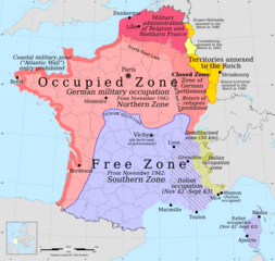
English: Occupation zones of France, Belgium and Luxembourg during the Second World War |
| Datum | |
| Bron | Eigen werk |
| Auteur | Victor falk - based on File:France map Lambert-93 with regions and departments-occupation.svg |
Licentie
Ik, de auteursrechthebbende van dit werk, maak het hierbij onder de volgende licentie beschikbaar:
Dit bestand is gelicenseerd onder de Creative Commons-licentie Naamsvermelding-Gelijk delen 3.0 Unported
- De gebruiker mag:
- Delen – het werk kopiëren, verspreiden en doorgeven
- Remixen – afgeleide werken maken
- Onder de volgende voorwaarden:
- naamsvermelding – U moet op een gepaste manier aan naamsvermelding doen, een link naar de licentie geven, en aangeven of er wijzigingen in het werk zijn aangebracht. U mag dit op elke redelijke manier doen, maar niet zodanig dat de indruk wordt gewekt dat de licentiegever instemt met uw werk of uw gebruik van zijn werk.
- Gelijk delen – Als u het werk heeft geremixt, veranderd, of erop heeft voortgebouwd, moet u het gewijzigde materiaal verspreiden onder dezelfde licentie als het oorspronkelijke werk, of een daarmee compatibele licentie.
Bestandsgeschiedenis
Klik op een datum/tijd om het bestand te zien zoals het destijds was.
| Datum/tijd | Miniatuur | Afmetingen | Gebruiker | Opmerking | |
|---|---|---|---|---|---|
| huidige versie | 14 jun 2014 01:40 | | 1.996 × 1.894 (975 kB) | Victor falk~commonswiki | 1) Corrected misplaced Grenoble not in DMZ 2) Coloured annexed yellow |
| 25 mei 2014 07:55 |  | 1.996 × 1.894 (981 kB) | Victor falk~commonswiki | alsace-lorraine | |
| 24 mei 2014 14:08 |  | 1.996 × 1.894 (974 kB) | Victor falk~commonswiki | luxembourg | |
| 23 mei 2014 08:25 |  | 1.996 × 1.894 (856 kB) | Victor falk~commonswiki | User created page with UploadWizard |
Bestandsgebruik
Geen enkele pagina gebruikt dit bestand.
Globaal bestandsgebruik
De volgende andere wiki's gebruiken dit bestand:
- Gebruikt op en.wikipedia.org
- Gebruikt op fa.wikipedia.org
- Gebruikt op fr.wikipedia.org
- Gebruikt op id.wikipedia.org
- Gebruikt op ms.wikipedia.org
- Gebruikt op no.wikipedia.org
- Gebruikt op pt.wikipedia.org