Bestand:GA-districts-110.png
Uiterlijk
GA-districts-110.png (177 × 199 pixels, bestandsgrootte: 27 kB, MIME-type: image/png)
Bestandsgeschiedenis
Klik op een datum/tijd om het bestand te zien zoals het destijds was.
| Datum/tijd | Miniatuur | Afmetingen | Gebruiker | Opmerking | |
|---|---|---|---|---|---|
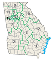
| huidige versie | 14 aug 2007 15:29 |  | 177 × 199 (27 kB) | Markles | {{PD-USGov-Atlas}} Map of Georgia's thirteen congressional districts, highlighting the 13th district (110th Congress), converted to PNG from original GIF. Source: [http://nationalatlas.gov/printable/images/preview/congdist/GA13_110.gif nationalatlas.gov] |
Bestandsgebruik
Dit bestand wordt op de volgende pagina gebruikt:
Globaal bestandsgebruik
De volgende andere wiki's gebruiken dit bestand:
- Gebruikt op ca.wikipedia.org
- Gebruikt op es.wikipedia.org


