
Bestand:Galapagos Islands topographic map-fr.png

Grootte van deze voorvertoning: 600 × 600 pixels. Andere resoluties: 240 × 240 pixels | 480 × 480 pixels | 768 × 768 pixels | 1.024 × 1.024 pixels | 2.160 × 2.160 pixels.
Oorspronkelijk bestand (2.160 × 2.160 pixels, bestandsgrootte: 2,14 MB, MIME-type: image/png)
| Dit is een bestand van Wikimedia Commons. Onderstaande beschrijving komt van de beschrijving van het bestand daar. |
Beschrijving
| Cameralocatie | | Deze en andere afbeeldingen in: OpenStreetMap |
|---|
| Beschrijving |
|
||
| Datum | |||
| Bron |
Own work
|
||
| Auteur | Eric Gaba (Sting - fr:Sting) | ||
| Toestemming (Hergebruik van dit bestand) |
|
||
| Andere versies |
[]
|

.png)


Licentie
Ik, de auteursrechthebbende van dit werk, maak het hierbij onder de volgende licenties beschikbaar:

|
Toestemming wordt verleend voor het kopiëren, verspreiden en/of wijzigen van dit document onder de voorwaarden van de GNU-licentie voor vrije documentatie, versie 1.2 of enige latere versie als gepubliceerd door de Free Software Foundation; zonder Invariant Sections, zonder Front-Cover Texts, en zonder Back-Cover Texts. Een kopie van de licentie is opgenomen in de sectie GNU-licentie voor vrije documentatie. |
This file is licensed under the Creative Commons Attribution-Share Alike Attribution-Share Alike 4.0 International, 3.0 Unported, 2.5 Generic, 2.0 Generic and 1.0 Generic license.
- De gebruiker mag:
- Delen – het werk kopiëren, verspreiden en doorgeven
- Remixen – afgeleide werken maken
- Onder de volgende voorwaarden:
- naamsvermelding – U moet op een gepaste manier aan naamsvermelding doen, een link naar de licentie geven, en aangeven of er wijzigingen in het werk zijn aangebracht. U mag dit op elke redelijke manier doen, maar niet zodanig dat de indruk wordt gewekt dat de licentiegever instemt met uw werk of uw gebruik van zijn werk.
- Gelijk delen – Als u het werk heeft geremixt, veranderd, of erop heeft voortgebouwd, moet u het gewijzigde materiaal verspreiden onder dezelfde licentie als het oorspronkelijke werk, of een daarmee compatibele licentie.
U mag zelf één van de licenties kiezen.
Bestandsgeschiedenis
Klik op een datum/tijd om het bestand te zien zoals het destijds was.
| Datum/tijd | Miniatuur | Afmetingen | Gebruiker | Opmerking | |
|---|---|---|---|---|---|
| huidige versie | 20 jul 2010 02:34 | | 2.160 × 2.160 (2,14 MB) | Sting | Reverted to version as of 14:35, 19 July 2010 : test ended |
| 20 jul 2010 02:28 |  | 2.160 × 2.160 (4,3 MB) | Sting | sRGB converted (just for test) | |
| 19 jul 2010 16:35 |  | 2.160 × 2.160 (2,14 MB) | Sting | Color profile | |
| 17 nov 2009 16:37 |  | 2.160 × 2.160 (2,14 MB) | Sting | Embedded sRGB profile | |
| 3 nov 2008 14:52 |  | 2.160 × 2.160 (2,06 MB) | Sting | Corrections | |
| 5 jul 2008 03:35 |  | 2.160 × 2.160 (2,06 MB) | Sting | Oups ! | |
| 5 jul 2008 03:19 |  | 2.160 × 2.160 (2,07 MB) | Sting | Several little improvements | |
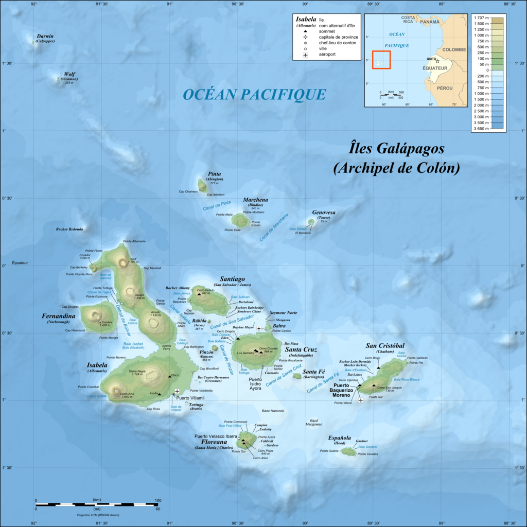
| 3 jul 2008 04:17 |  | 2.160 × 2.160 (1,87 MB) | Sting | == Summary == {{Location|00|30|00|S|90|30|00|W|scale:1000000}} <br/>{{Information |Description={{en|Topographic and bathymetric map of the Galápagos Islands, Ecuador.}} {{fr|Carte topographique et bathymétrique |
Bestandsgebruik
Geen enkele pagina gebruikt dit bestand.
Globaal bestandsgebruik
De volgende andere wiki's gebruiken dit bestand:
- Gebruikt op en.wikipedia.org
- Gebruikt op fr.wikipedia.org
- Gebruikt op fr.wiktionary.org
- Gebruikt op hu.wikipedia.org