
Bestand:Great Lakes 1913 Storm Shipwrecks.png

Oorspronkelijk bestand (4.000 × 2.400 pixels, bestandsgrootte: 799 kB, MIME-type: image/png)
| Dit is een bestand van Wikimedia Commons. Onderstaande beschrijving komt van de beschrijving van het bestand daar. |
Beschrijving
| Beschrijving |
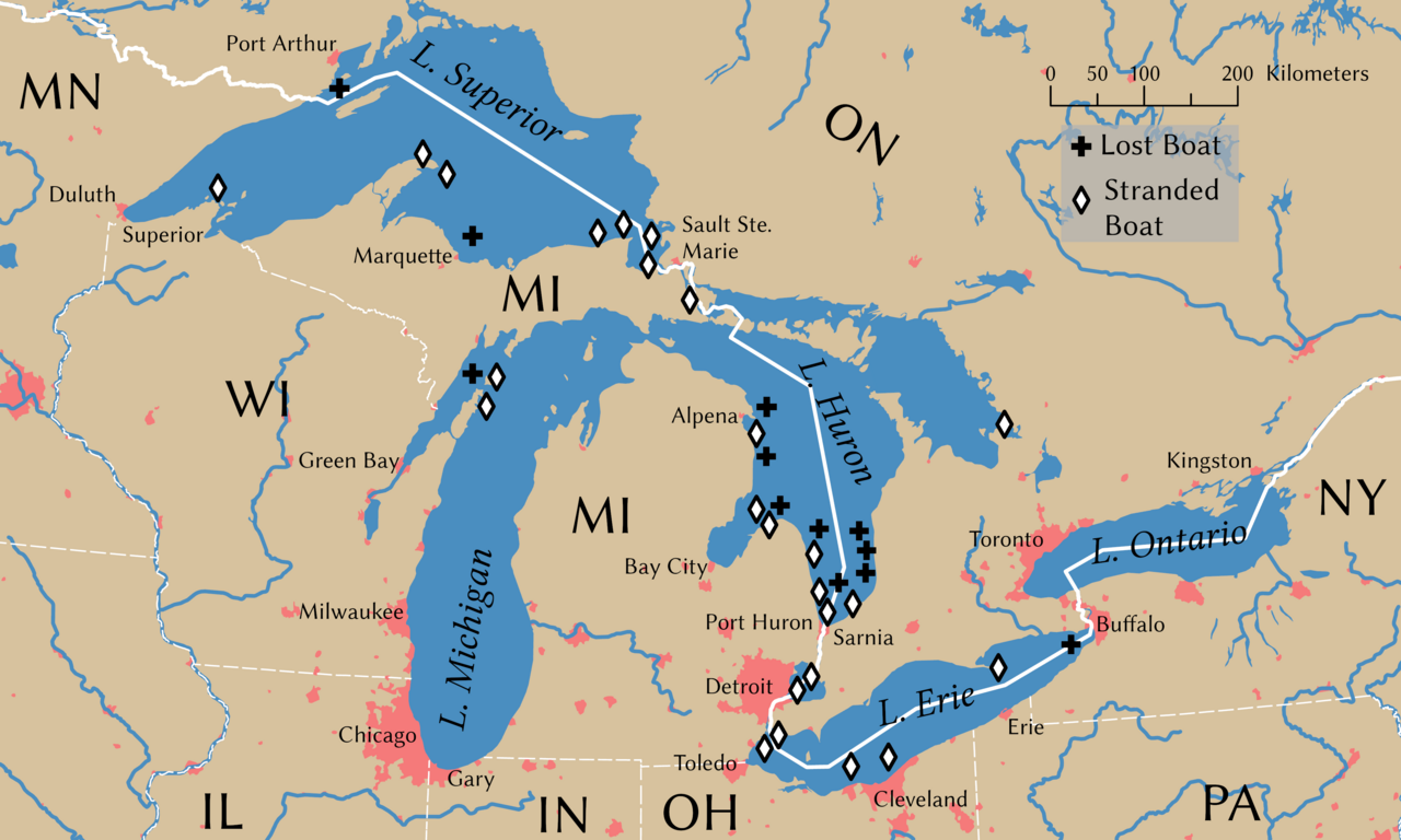
English: Shipwrecks during the Great Lakes Storm of 1913. Wreck locations come from Brown (2002, p. 203) |
||
| Datum | |||
| Bron | Eigen werk | ||
| Maker | |||
| Naamsvermeldingen | © Tom Fish, geo.fish // Creative Commons BY-SA 4.0 | ||
| Toestemming (Hergebruik van dit bestand) |
|
||
| Geotemporal data | |||
| Geodetisch coördinatensysteem | NAD 1983 Great Lakes Basin Albers [WKID: 31734] | ||
| Schaal | 1:11,792,324 | ||
| Archival data | |||
| artwork-references | Brown, David G. (2002) White Hurricane: A Great Lakes November Gale and America's Deadliest Maritime Disaster, International Marine/McGraw-Hill ISBN: 0-07-138037-X. | ||
| PNG ontwikkeling | Deze kaart is gemaakt met ArcGIS Pro |
||
Licentie
Data
Rivers, lakes, and urban areas
| This file uses data that was sourced from Natural Earth, a public domain dataset. From the terms of use:
All versions of Natural Earth raster + vector map data found on this website are in the public domain. You may use the maps in any manner, including modifying the content and design, electronic dissemination, and offset printing. The primary authors, Tom Patterson and Nathaniel Vaughn Kelso, and all other contributors renounce all financial claim to the maps and invites you to use them for personal, educational, and commercial purposes. |
Shipwreck locations
The locations of the shipwrecks are facts and are not eligible for copyright protection
| Dit werk komt niet in aanmerking voor auteursrechtelijke bescherming, omdat het volledig uit algemeen beschikbare informatie bestaat en geen origineel auteurschap bevat; derhalve valt het werk in het publieke domein. |
International boundary
The international boundaries are sourced from the Large Scale International Boundaries published by the US Department of State
| This image is a work of a United States Department of State employee, taken or made as part of that person's official duties. As a work of the U.S. federal government, the image is in the public domain per 17 U.S.C. § 101 and § 105 and the Department Copyright Information. |  |
State boundary
The state boundaries are sourced from STATE_BOUNDS the United States Geological Survey
Deze afbeelding bevindt zich in het publiek domein omdat het materiaal bevat dat oorspronkelijk afkomstig is van de United States Geological Survey, een agentschap van de United States Department of the Interior. Voor meer informatie, zie het officiële USGS-auteursrechtenbeleid
|
Final Map
- De gebruiker mag:
- Delen – het werk kopiëren, verspreiden en doorgeven
- Remixen – afgeleide werken maken
- Onder de volgende voorwaarden:
- naamsvermelding – U moet op een gepaste manier aan naamsvermelding doen, een link naar de licentie geven, en aangeven of er wijzigingen in het werk zijn aangebracht. U mag dit op elke redelijke manier doen, maar niet zodanig dat de indruk wordt gewekt dat de licentiegever instemt met uw werk of uw gebruik van zijn werk.
- Gelijk delen – Als u het werk heeft geremixt, veranderd, of erop heeft voortgebouwd, moet u het gewijzigde materiaal verspreiden onder dezelfde licentie als het oorspronkelijke werk, of een daarmee compatibele licentie.
Bestandsgeschiedenis
Klik op een datum/tijd om het bestand te zien zoals het destijds was.
| Datum/tijd | Miniatuur | Afmetingen | Gebruiker | Opmerking | |
|---|---|---|---|---|---|
| huidige versie | 9 nov 2021 01:54 | | 4.000 × 2.400 (799 kB) | Guerillero | Remedy copyright issues |
| 27 feb 2007 21:07 |  | 1.786 × 1.194 (1,05 MB) | SalomonCeb | Shipwrecks during the en:Great Lakes Storm of 1913. Reference: ''White Hurricane'', by David G. Brown, 2002. All text and icons were added to the PD blank map located at: http://walrus.wr.usgs.gov/infobank/gazette/jpg/regions/fr_glez.jpg {{PD-s |
Bestandsgebruik
Dit bestand wordt op de volgende pagina gebruikt:
Globaal bestandsgebruik
De volgende andere wiki's gebruiken dit bestand:
- Gebruikt op ca.wikipedia.org
- Gebruikt op de.wikipedia.org
- Gebruikt op de.wiktionary.org
- Gebruikt op en.wikipedia.org
- Gebruikt op fr.wikipedia.org
- Gebruikt op ru.wikipedia.org
- Gebruikt op uz.wikipedia.org