
Bestand:Great Lakes bathymetry map.png
Oorspronkelijk bestand (1.024 × 731 pixels, bestandsgrootte: 1,34 MB, MIME-type: image/png)
| Dit is een bestand van Wikimedia Commons. Onderstaande beschrijving komt van de beschrijving van het bestand daar. |
Beschrijving
| Beschrijving |
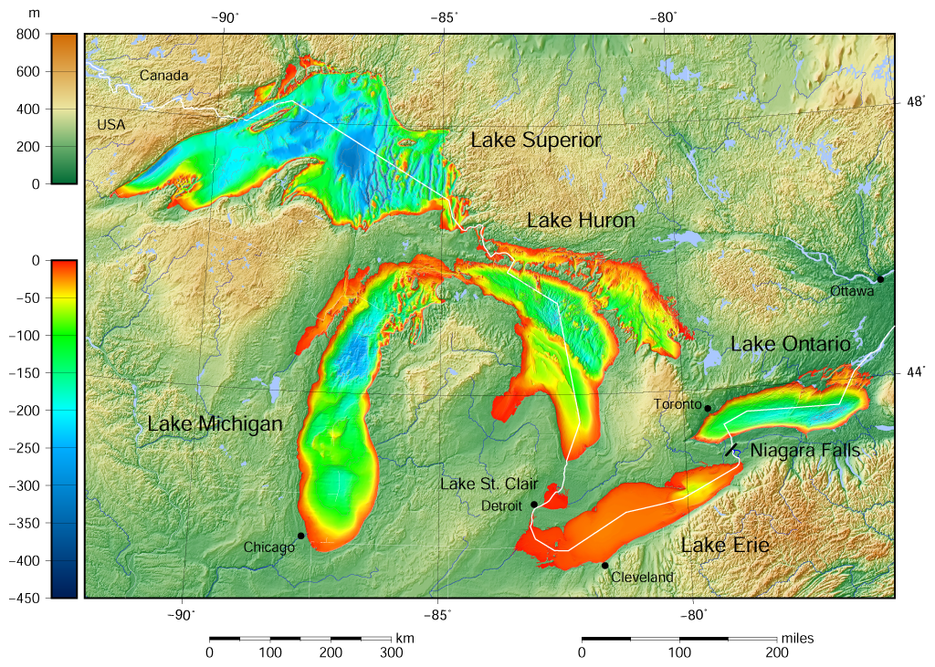
English: Great Lakes bathymetry and surrounding area shaded relief map. Lakes are contoured with interval 100 m. Lake Superior is incomplete. |
| Datum | |
| Bron |
Own work using: the following Public Domain datasets (grids):
The color palette of the depth scale was made to be more or less similar to the color palettes used on the NGDC Great Lakes maps. |
| Auteur | Darekk2 using the Great Lakes Bathymetry and GLOBE tiles |
| Andere versies |
|

Licentie
Attribution (in addition to the author of this map):
The NGDC in it's copyright notice says:
As required by 17 U.S.C. 403, third parties producing copyrighted works consisting predominantly of the material produced by U.S. government agencies must provide notice with such work(s) identifying the U.S. Government material incorporated and stating that such material is not subject to copyright protection within the United States. (...)
(for credits see the Source section).
and Great Lakes Bathymetry and GLOBE
(see above and the Source section)
- De gebruiker mag:
- Delen – het werk kopiëren, verspreiden en doorgeven
- Remixen – afgeleide werken maken
- Onder de volgende voorwaarden:
- naamsvermelding – U moet op een gepaste manier aan naamsvermelding doen, een link naar de licentie geven, en aangeven of er wijzigingen in het werk zijn aangebracht. U mag dit op elke redelijke manier doen, maar niet zodanig dat de indruk wordt gewekt dat de licentiegever instemt met uw werk of uw gebruik van zijn werk.
- Gelijk delen – Als u het werk heeft geremixt, veranderd, of erop heeft voortgebouwd, moet u het gewijzigde materiaal verspreiden onder dezelfde licentie als het oorspronkelijke werk, of een daarmee compatibele licentie.
Bestandsgeschiedenis
Klik op een datum/tijd om het bestand te zien zoals het destijds was.
| Datum/tijd | Miniatuur | Afmetingen | Gebruiker | Opmerking | |
|---|---|---|---|---|---|
| huidige versie | 9 mei 2015 17:46 | | 1.024 × 731 (1,34 MB) | Darekk2 | more accurate shorelines, the lakes tiles better assembled, added Canada, USA and Lake St. Clair labels, moved Detroit label, Michigan Lake - retouched western part of Green Bay |
| 25 mrt 2015 12:03 |  | 1.024 × 731 (1,34 MB) | Darekk2 | changed illumination for shaded relief | |
| 25 mrt 2015 03:29 |  | 1.024 × 731 (1,33 MB) | Darekk2 | changed palette a little | |
| 24 mrt 2015 22:21 |  | 1.024 × 731 (1,61 MB) | Darekk2 | User created page with UploadWizard |
Bestandsgebruik
Dit bestand wordt op de volgende pagina gebruikt:
Globaal bestandsgebruik
De volgende andere wiki's gebruiken dit bestand:
- Gebruikt op ar.wikipedia.org
- Gebruikt op en.wikipedia.org
- Gebruikt op fi.wikipedia.org
- Gebruikt op ja.wikipedia.org
- Gebruikt op sr.wikipedia.org
- Gebruikt op tt.wikipedia.org
- Gebruikt op uk.wikipedia.org
- Gebruikt op vep.wikipedia.org
- Gebruikt op www.wikidata.org
- Gebruikt op zh-yue.wikipedia.org