
Bestand:Hampshire UK location map.svg

Afmetingen van deze voorvertoning van het type PNG van dit SVG-bestand: 704 × 599 pixels Andere resoluties: 282 × 240 pixels | 564 × 480 pixels | 902 × 768 pixels | 1.203 × 1.024 pixels | 2.406 × 2.048 pixels | 1.425 × 1.213 pixels.
Oorspronkelijk bestand (SVG-bestand, nominaal 1.425 × 1.213 pixels, bestandsgrootte: 2,35 MB)
| Dit is een bestand van Wikimedia Commons. Onderstaande beschrijving komt van de beschrijving van het bestand daar. |
| Beschrijving |
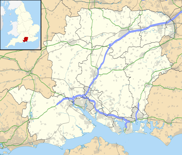
Map of Hampshire, UK with the following information shown:
Equirectangular map projection on WGS 84 datum, with N/S stretched 155% Geographic limits:
|
| Datum | |
| Bron |
|
| Auteur | Nilfanion, created using Ordnance Survey data |
| Toestemming (Hergebruik van dit bestand) |
Dit bestand is gelicenseerd onder de Creative Commons-licentie Naamsvermelding-Gelijk delen 3.0 Unported Naamsvermelding: Contains Ordnance Survey data © Crown copyright and database right
|
| Andere versies | File:Hampshire UK district map (blank).svg - Blank map |
.svg)
Bestandsgeschiedenis
Klik op een datum/tijd om het bestand te zien zoals het destijds was.
| Datum/tijd | Miniatuur | Afmetingen | Gebruiker | Opmerking | |
|---|---|---|---|---|---|
| huidige versie | 26 sep 2010 20:55 | | 1.425 × 1.213 (2,35 MB) | Nilfanion | {{Information |Description=Map of Hampshire, UK with the following information shown: *Administrative borders *Coastline, lakes and rivers *Roads and railways *Urban areas Equirectangular map projection on WGS 84 datum, with N/S stretched |
Bestandsgebruik
Meer dan 100 pagina's gebruiken dit bestand. De volgende lijst geeft alleen de eerste 100 pagina's weer die dit bestand gebruiken. Er is ook een volledige lijst beschikbaar.
- Abbotswood
- Aldershot
- Alton (Hampshire)
- Ampfield
- Amport
- Andover (Hampshire)
- Appleshaw
- Awbridge
- Badger Farm
- Barton Stacey
- Basingstoke
- Baughurst
- Beaulieu (Hampshire)
- Beauworth
- Beech
- Bentworth
- Bighton
- Binsted
- Bishops Sutton
- Bishopstoke
- Boarhunt
- Boldre
- Braishfield
- Bramshaw
- Bramshill
- Bransgore
- Breamore
- Brockenhurst
- Bullington
- Burghclere
- Buriton
- Bursledon
- Chawton
- Chilbolton
- Chilcomb
- Chineham
- Clanfield (Hampshire)
- Cliddesden
- Colden Common
- Compton and Shawford
- Copythorne
- Crondall
- Crookham Village
- Curdridge
- Damerham
- Deane
- Denmead
- Denny Lodge
- Dogmersfield
- Droxford
- Durley
- East Meon
- East Tisted
- Ecchinswell, Sydmonton and Bishops Green
- Emsworth (Hampshire)
- Eversley
- Exbury and Lepe
- Farleigh Wallop
- Farnborough (Hampshire)
- Farringdon (Hampshire)
- Fleet (Hampshire)
- Fordingbridge
- Four Marks
- Grayshott
- Greatham
- Greywell
- Hamble-le-Rice
- Hambledon (Hampshire)
- Hartley Wintney
- Hawkley
- Headbourne Worthy
- Headley (East Hampshire)
- Heckfield
- Hedge End
- Herriard
- Hordle
- Horndean
- Hursley
- Kilmeston
- King's Somborne
- Kings Worthy
- Kingsclere
- Langrish
- Lasham
- Leckford
- Lindford
- Linkenholt
- Liss
- Lockerley
- Longparish
- Longstock
- Lovedean
- Lyndhurst (Engeland)
- Odiham
- Portsmouth (Verenigd Koninkrijk)
- Steventon (Hampshire)
- Tadley
- Totton and Eling
- Upper and Lower Froyle
- Waterlooville
Meer koppelingen naar dit bestand bekijken.
Globaal bestandsgebruik
De volgende andere wiki's gebruiken dit bestand:
- Gebruikt op ar.wikipedia.org
- Gebruikt op bg.wikipedia.org
- Gebruikt op ceb.wikipedia.org
- Gebruikt op en.wikipedia.org
- Emsworth
- Hayling Island
- Hampshire
- Waterlooville
- Winchester
- Beaulieu, Hampshire
- Southsea
- Domus Dei
- Winchester Cathedral
- Romsey Abbey
- Calleva Atrebatum
- Tadley
- National Motor Museum, Beaulieu
- Wickham, Hampshire
- Romsey
- Little London, Tadley, Hampshire
- Lovedean
- Farnborough, Hampshire
- Fleet, Hampshire
- Church Crookham
- Blackbushe Airport
- Havant
- Nursling
- Fordingbridge
- Southampton Airport
- Fareham
- Whale Island, Hampshire
- Basingstoke
- Aldershot
- Eastleigh
- Alton, Hampshire
- Andover, Hampshire
- Lymington
- Portchester
- Ringwood, Hampshire
- Yateley
- Chawton
- New Milton
- Brockenhurst
- Bishop's Waltham
- Portchester Castle
- Hythe, Hampshire
- Portsea Island
- RAF Odiham
- University of Portsmouth
- Stratfield Saye House
Globaal gebruik van dit bestand bekijken.