
Bestand:Jackson Valley Campaign Part1.png
Grootte van deze voorvertoning: 673 × 599 pixels. Andere resoluties: 270 × 240 pixels | 539 × 480 pixels | 863 × 768 pixels | 1.150 × 1.024 pixels | 2.100 × 1.870 pixels.
Oorspronkelijk bestand (2.100 × 1.870 pixels, bestandsgrootte: 1,66 MB, MIME-type: image/png)
| Dit is een bestand van Wikimedia Commons. Onderstaande beschrijving komt van de beschrijving van het bestand daar. |
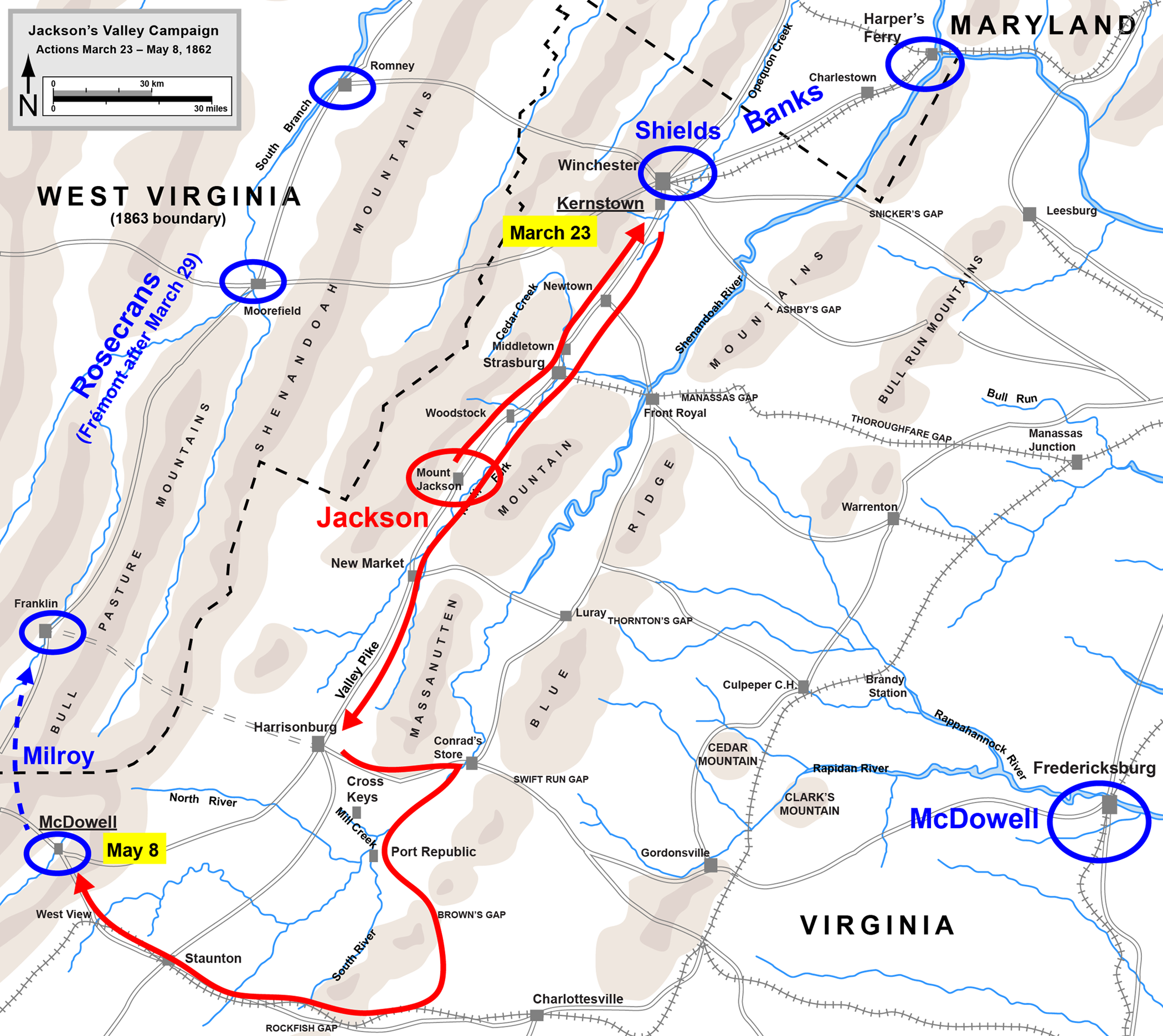
| Beschrijving | Map of Stonewall Jackson's Valley Campaign, Part 1 of 2 |
| Bron | en:Image:Jackson Valley Campaign Part1.png: 1536×1191 (547,280 bytes) (Map of Jackson's Valley Campaign of the American Civil War, part 1. Drawn by Hal Jespersen in Adobe Illustrator CS5. Graphic source file is available at http://www.posix.com/CWmaps/ {{cc-by-3.0|Map by Hal Jespersen, www.posix.com/CW}}) |
| Auteur | Hlj |
| Toestemming (Hergebruik van dit bestand) |
Dit bestand is gelicenseerd onder de Creative Commons-licentie Naamsvermelding 3.0 Unported Naamsvermelding: Map by Hal Jespersen, www.posix.com/CW
|
Bestandsgeschiedenis
Klik op een datum/tijd om het bestand te zien zoals het destijds was.
| Datum/tijd | Miniatuur | Afmetingen | Gebruiker | Opmerking | |
|---|---|---|---|---|---|
| huidige versie | 29 mrt 2011 02:53 | | 2.100 × 1.870 (1,66 MB) | Hlj | Update to more recent graphical style. Improve accuracy of topography and troop positions. Add legend/scale. |
| 17 jul 2009 21:24 |  | 1.579 × 1.256 (414 kB) | Hlj | Corrected date for McDowell | |
| 4 jul 2009 00:38 |  | 1.579 × 1.256 (414 kB) | Hlj | {{Information |Description=Map of Jackson's Valley Campaign of the American Civil War. Added scale, state names, some cleanups to my previous version. Drawn in Adobe Illustrator CS3 by Hal Jespersen. Graphic source file is available at http://www.posi | |
| 13 jul 2006 17:10 |  | 1.536 × 1.191 (534 kB) | Cave cattum | {{Information| |Description= Map of Stonewall Jackson's Valley Campaign, Part 1 of 2 |Source= en:Image:Jackson Valley Campaign Part1.png: ''<nowiki>1536×1191 (547,280 bytes) (Map of Jackson's Valley Campaign of the American Civil War, part 1. Drawn |
Bestandsgebruik
Dit bestand wordt op de volgende 3 pagina's gebruikt:
Globaal bestandsgebruik
De volgende andere wiki's gebruiken dit bestand:
- Gebruikt op da.wikipedia.org
- Gebruikt op fr.wikipedia.org
- Gebruikt op it.wikipedia.org
- Gebruikt op ja.wikipedia.org
- Gebruikt op ko.wikipedia.org
- Gebruikt op no.wikipedia.org
- Gebruikt op pl.wikipedia.org
- Gebruikt op ru.wikipedia.org
- Gebruikt op zh.wikipedia.org