
Bestand:Kansas City Southern Railway system map.svg

Afmetingen van deze voorvertoning van het type PNG van dit SVG-bestand: 800 × 457 pixels Andere resoluties: 320 × 183 pixels | 640 × 366 pixels | 1.024 × 585 pixels | 1.280 × 731 pixels | 2.560 × 1.463 pixels | 1.400 × 800 pixels.
Oorspronkelijk bestand (SVG-bestand, nominaal 1.400 × 800 pixels, bestandsgrootte: 543 kB)
| Dit is een bestand van Wikimedia Commons. Onderstaande beschrijving komt van de beschrijving van het bestand daar. |
Beschrijving
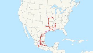
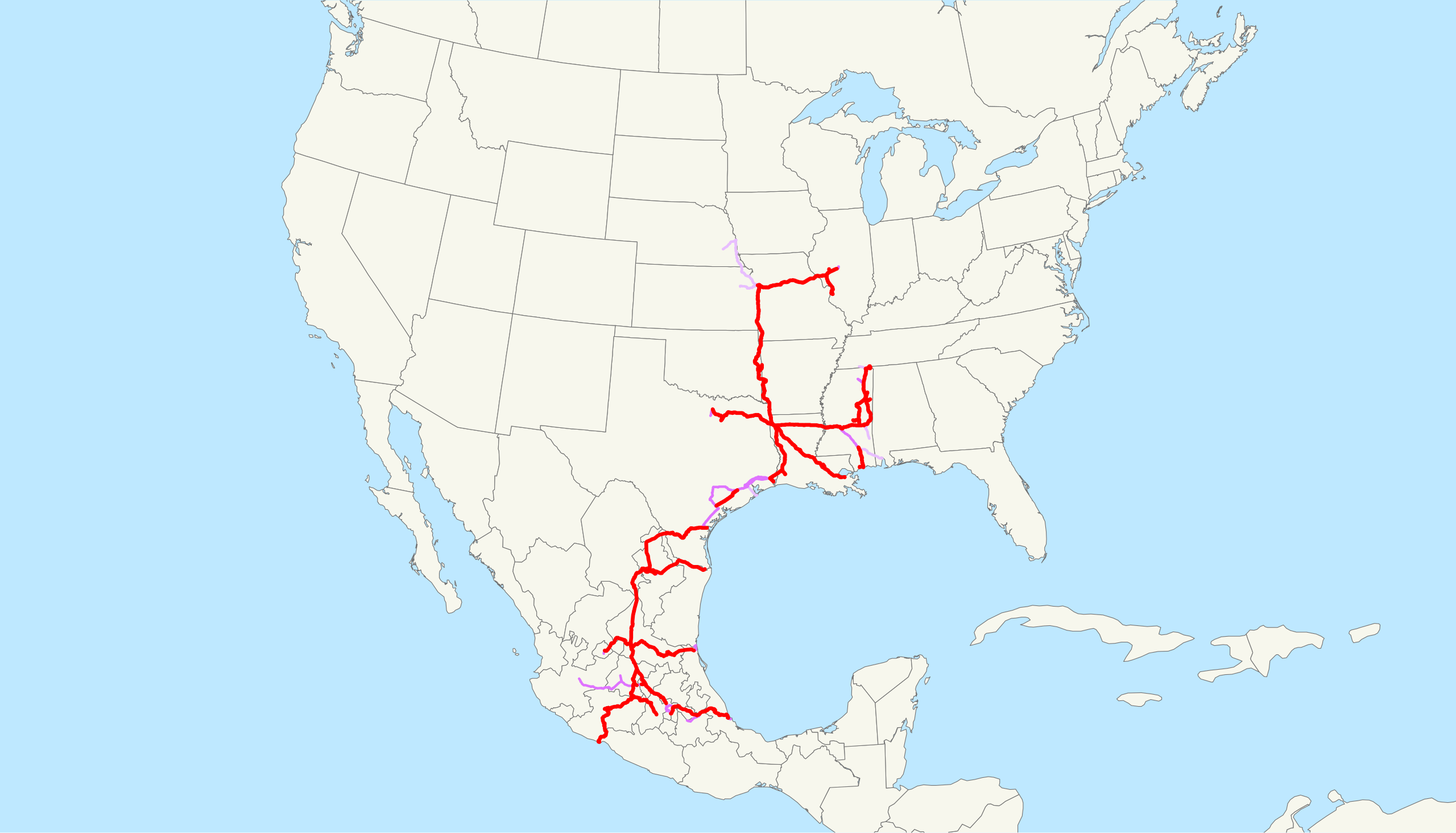
| Beschrijving | This is a map of the Kansas City Southern Railway as of 2009, with trackage rights in purple (haulage rights are lighter). Email me if you would like a copy of the GIS data I created (modified from Bureau of Transportation Statistics North American Transportation Atlas Data) or if you see any errors. |
| Datum | 20 februari 2009 (originele uploaddatum) |
| Bron | Geen machineleesbare bron opgegeven. Eigen werk aangenomen (gebaseerd op auteursrechtclaims). |
| Auteur | Geen machineleesbare auteur aanwezig. Op basis van auteursrechtclaims wordt auteur NE2 aangenomen. |
Licentie
| Ik, de auteursrechthebbende van dit werk, geef dit werk vrij in het publieke domein. Dit is wereldwijd van toepassing. In sommige landen is dit wettelijk niet mogelijk; in die gevallen geldt: Ik sta iedereen toe dit werk voor eender welk doel te gebruiken, zonder enige voorwaarden, tenzij zulke voorwaarden door de wet worden voorgeschreven. |
Bestandsgeschiedenis
Klik op een datum/tijd om het bestand te zien zoals het destijds was.
| Datum/tijd | Miniatuur | Afmetingen | Gebruiker | Opmerking | |
|---|---|---|---|---|---|
| huidige versie | 23 feb 2009 15:09 | | 1.400 × 800 (543 kB) | NE2 | Changed the display of lines owned by the government for the purposes of passenger rail, so that if KCS is the primary freight operator it is not shown as trackage rights. |
| 20 feb 2009 06:30 |  | 1.400 × 800 (542 kB) | NE2 | == Summary == This is a map of the Kansas City Southern Railway as of 2009, with trackage rights in purple (haulage rights are lighter). Email me if you would like a copy of the GIS dat |
Bestandsgebruik
Dit bestand wordt op de volgende pagina gebruikt:
Globaal bestandsgebruik
De volgende andere wiki's gebruiken dit bestand:
- Gebruikt op de.wikipedia.org
- Gebruikt op en.wikipedia.org
- Gebruikt op es.wikipedia.org
- Gebruikt op fr.wikipedia.org
- Gebruikt op hu.wikipedia.org
- Gebruikt op id.wikipedia.org
- Gebruikt op it.wikipedia.org
- Gebruikt op ja.wikipedia.org
- Gebruikt op ko.wikipedia.org
- Gebruikt op pt.wikipedia.org
- Gebruikt op www.wikidata.org
- Gebruikt op zh.wikipedia.org