
Bestand:Karte Kanton Freiburg 2010.png
Grootte van deze voorvertoning: 590 × 599 pixels. Andere resoluties: 236 × 240 pixels | 472 × 480 pixels | 756 × 768 pixels | 1.008 × 1.024 pixels | 2.066 × 2.099 pixels.
Oorspronkelijk bestand (2.066 × 2.099 pixels, bestandsgrootte: 948 kB, MIME-type: image/png)
| Dit is een bestand van Wikimedia Commons. Onderstaande beschrijving komt van de beschrijving van het bestand daar. |
| Beschrijving |
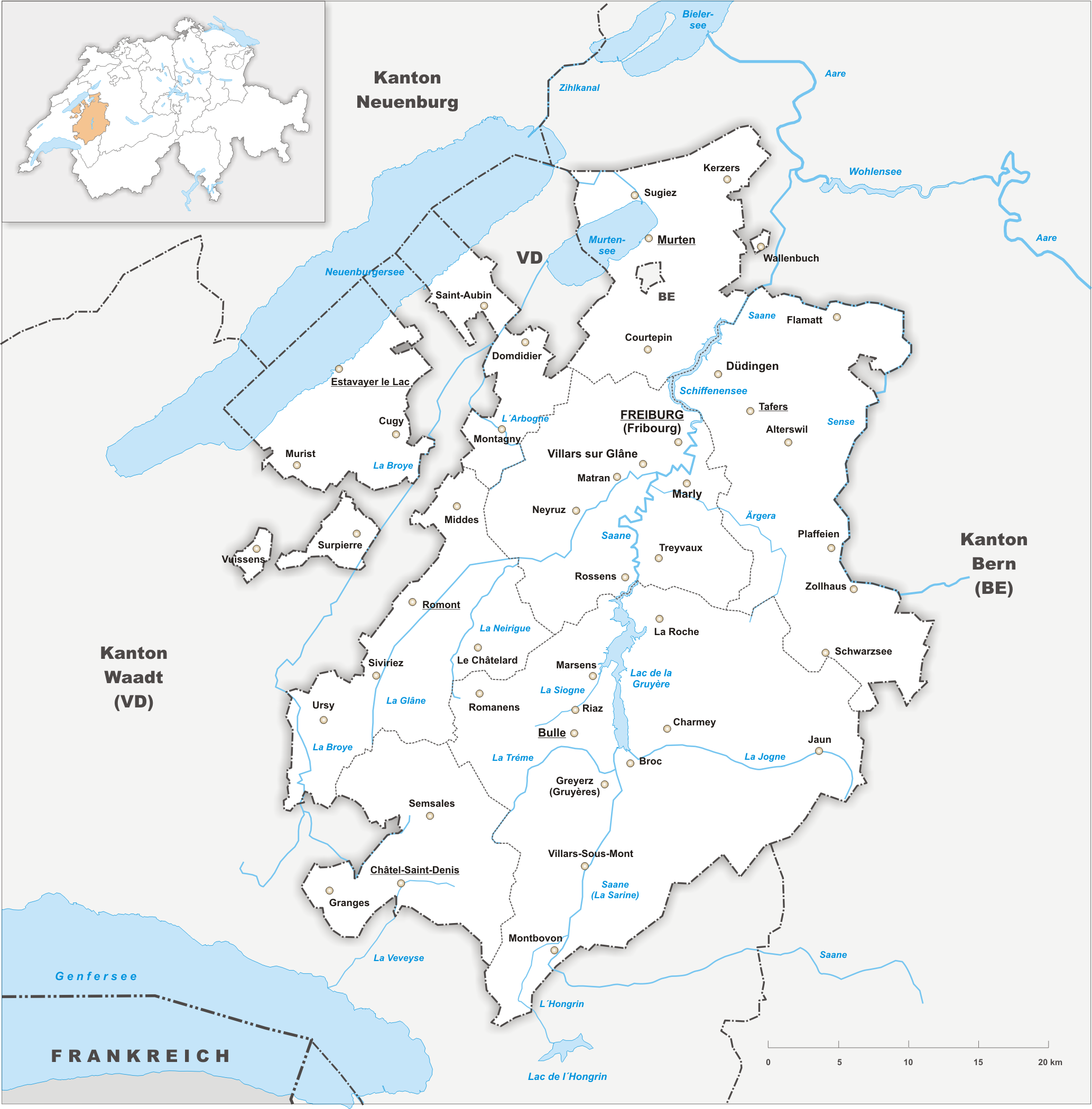
Deutsch: Karte des Kanton Freiburg. |
||||||||
| Datum | |||||||||
| Bron | Eigen werk | ||||||||
| Auteur | Tschubby | ||||||||
| Toestemming (Hergebruik van dit bestand) |
Ik, de auteursrechthebbende van dit werk, maak het hierbij onder de volgende licenties beschikbaar:
Dit bestand is gelicenseerd onder de Creative Commons-licenties Naamsvermelding-Gelijk delen 2.5 Algemeen, 2.0 Algemeen en 1.0 Algemeen.
U mag zelf één van de licenties kiezen. |

Bestandsgeschiedenis
Klik op een datum/tijd om het bestand te zien zoals het destijds was.
| Datum/tijd | Miniatuur | Afmetingen | Gebruiker | Opmerking | |
|---|---|---|---|---|---|
| huidige versie | 15 mrt 2022 23:34 | | 2.066 × 2.099 (948 kB) | Delusion23 | Removed BE |
| 15 mrt 2022 23:27 |  | 2.066 × 2.099 (949 kB) | Delusion23 | Clavaleyres now part of Fribourg | |
| 22 okt 2009 22:28 |  | 2.066 × 2.099 (1,09 MB) | Tschubby | {{Information |Description= |Source= |Date= |Author= |Permission= |other_versions= }} | |
| 22 okt 2009 22:13 |  | 2.066 × 2.099 (1,08 MB) | Tschubby | {{Information |Description= {{de| Karte des Kanton Freiburg.}} |Source={{own}} |Date= 22.10.2009 |Author= Tschubby |Permission= {{self|GFDL|Cc-by-sa-3.0-migrated|Cc-by-sa-2.5,2.0,1.0}} }} [[Category:Maps of t |
Bestandsgebruik
Dit bestand wordt op de volgende pagina gebruikt:
Globaal bestandsgebruik
De volgende andere wiki's gebruiken dit bestand:
- Gebruikt op ar.wikipedia.org
- Gebruikt op ast.wikipedia.org
- Gebruikt op be-tarask.wikipedia.org
- Gebruikt op be.wikipedia.org
- Gebruikt op bg.wikipedia.org
- Gebruikt op ca.wikipedia.org
- Gebruikt op ceb.wikipedia.org
- Gebruikt op el.wikipedia.org
- Gebruikt op en.wikipedia.org
- Gebruikt op eu.wikipedia.org
- Gebruikt op gl.wikipedia.org
- Gebruikt op hu.wikipedia.org
- Gebruikt op ia.wikipedia.org
- Gebruikt op ilo.wikipedia.org
- Gebruikt op li.wikipedia.org
- Gebruikt op lld.wikipedia.org
- Gebruikt op lmo.wikipedia.org
- Gebruikt op mk.wikipedia.org
- Gebruikt op mzn.wikipedia.org
- Gebruikt op oc.wikipedia.org
- Gebruikt op sk.wikipedia.org
- Gebruikt op sr.wikipedia.org
- Gebruikt op th.wikipedia.org
- Gebruikt op ur.wikipedia.org
- Gebruikt op www.wikidata.org