
Bestand:King John's campaign 1215-6.png
Grootte van deze voorvertoning: 458 × 600 pixels. Andere resoluties: 183 × 240 pixels | 366 × 480 pixels | 781 × 1.023 pixels.
Oorspronkelijk bestand (781 × 1.023 pixels, bestandsgrootte: 165 kB, MIME-type: image/png)
| Dit is een bestand van Wikimedia Commons. Onderstaande beschrijving komt van de beschrijving van het bestand daar. |
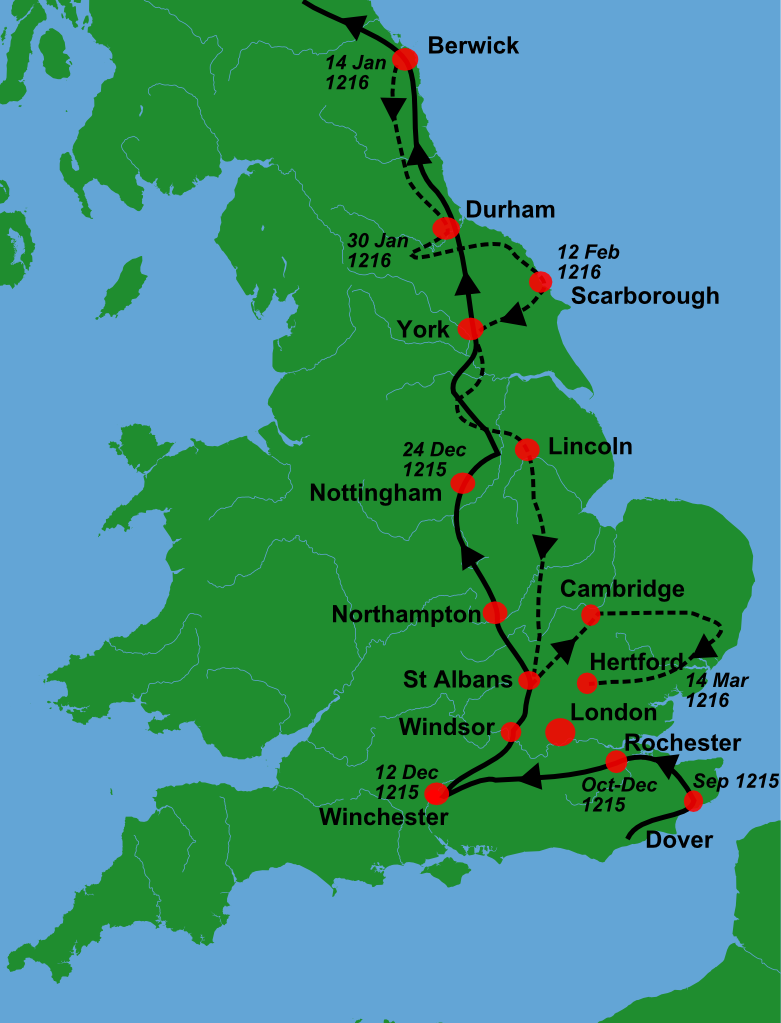
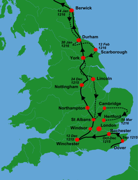
| Beschrijving | A blank locator map for Great Britain, with King John's 1216-6 military campaigns superimposed on it (using information from Warren, "King John", p. 250. The idea is to superimpose Image:dot4gb.svg at the appropriate point. See w:Template:GBthumb for code to do this. These two images can replace any locator map posted by Lupin - see w:Special:Contributions/LupinBot. This is a vectorized version of Image:Gb4dot.png, with the scale changed from 200 km to 150 km/150 miles. The shoreline data come from the file gshhs_h.b from the GSHHS, and the rivers and the Irish border come from the CIA World DataBank II; both sources are in the public domain. Mercator projection. == |
| Datum | (UTC) |
| Bron |
Own work using:
|
| Auteur |
|
| Dit is een geretoucheerde foto, wat betekent dat de originele versie digitaal aangepast is. Aanpassingen: Trimmed, campaign superimposed. Het origineel kan hier bekeken worden: Gb4dot.svg. Aanpassingen gedaan door Hchc2009.
|
Ik, de auteursrechthebbende van dit werk, maak het hierbij onder de volgende licentie beschikbaar:
| Ik, de auteursrechthebbende van dit werk, geef dit werk vrij in het publieke domein. Dit is wereldwijd van toepassing. In sommige landen is dit wettelijk niet mogelijk; in die gevallen geldt: Ik sta iedereen toe dit werk voor eender welk doel te gebruiken, zonder enige voorwaarden, tenzij zulke voorwaarden door de wet worden voorgeschreven. |
Oorspronkelijk uploadlogboek
This image is a derivative work of the following images:
- File:Gb4dot.svg licensed with PD-self
Uploaded with derivativeFX
Bestandsgeschiedenis
Klik op een datum/tijd om het bestand te zien zoals het destijds was.
| Datum/tijd | Miniatuur | Afmetingen | Gebruiker | Opmerking | |
|---|---|---|---|---|---|
| huidige versie | 2 jan 2011 12:08 | | 781 × 1.023 (165 kB) | Hchc2009 | {{Information |Description=A blank locator map for Great Britain, with King John's 1216-6 military campaigns superimposed on it (using information from Warren, "King John", p.250. The idea is to superimpose Image:dot4gb.svg at the appropriate point. |
Bestandsgebruik
Dit bestand wordt op de volgende pagina gebruikt:
Globaal bestandsgebruik
De volgende andere wiki's gebruiken dit bestand:
- Gebruikt op az.wikipedia.org
- Gebruikt op en.wikipedia.org
- Gebruikt op fr.wikipedia.org
- Gebruikt op gl.wikipedia.org
- Gebruikt op hu.wikipedia.org
- Gebruikt op ru.wikipedia.org
- Gebruikt op tr.wikipedia.org
- Gebruikt op zh.wikipedia.org