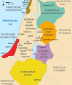
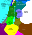
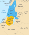
Bestand:Kingdoms of Israel and Judah map 830.svg

Pagina-inhoud wordt niet ondersteund in andere talen.
Uit Wikipedia, de vrije encyclopedie

Oorspronkelijk bestand(SVG-bestand, nominaal 720 × 859 pixels, bestandsgrootte: 96 kB)

Deze afbeeldingen renderen in de taal .

Beschrijving
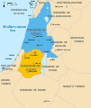
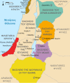
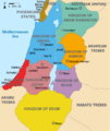
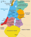
English: Approximate map showing the Kingdoms of Israel (blue) and Judah (orange), ancient Southern Levant borders and ancient cities such as Urmomium and Jerash. The map shows the region in the 9th century BCE.
Italiano: Il regno di Giuda e quello di Israele nell'età del ferro (VIII secolo a.C.).
日本語: 紀元前830年代のユダ王国(黄色).
Русский: Царство Иудея 927 по 526 гг. до н. э. Отсюда иудеи были сосланы завоевателями в Вавилонский регион.
Bahasa Indonesia: Peta kerajaan-kerajaan di daerah tersebut pada abad 9 SM.
Simple English: The northern Kingdom of Israel and the Kingdom of Judah to the south.
Srpskohrvatski / српскохрватски: Karta Sjevernog i JUžnog Kraljevstva. Samarija je bila glavni grad Kraljevstva Izrael (plavo). 830-e pne.,.
Latviešu: Izraēlas un Jūdejas karalistes. Jūdejas karaliste (dzeltenā) ap 830. gadu p.m.ē.
Datum (UTC)
Bron http://www.jewishvirtuallibrary.org/map-of-israel-and-judah-733-bce
Auteur
Andere versies

[bewerken]

Color scheme 1
Color scheme 2
Israel and Judah colored
Just Israel and Judah
Ik, de auteursrechthebbende van dit werk, maak het hierbij onder de volgende licenties beschikbaar:
w:nl:Creative Commons
naamsvermelding Gelijk delen
Dit bestand is gelicenseerd onder de Creative Commons-licentie Naamsvermelding-Gelijk delen 3.0 Unported
De gebruiker mag:
  • Delen – het werk kopiëren, verspreiden en doorgeven
  • Remixen – afgeleide werken maken
Onder de volgende voorwaarden:
  • naamsvermelding – U moet op een gepaste manier aan naamsvermelding doen, een link naar de licentie geven, en aangeven of er wijzigingen in het werk zijn aangebracht. U mag dit op elke redelijke manier doen, maar niet zodanig dat de indruk wordt gewekt dat de licentiegever instemt met uw werk of uw gebruik van zijn werk.
  • Gelijk delen – Als u het werk heeft geremixt, veranderd, of erop heeft voortgebouwd, moet u het gewijzigde materiaal verspreiden onder dezelfde licentie als het oorspronkelijke werk, of een daarmee compatibele licentie.
GNU head Toestemming wordt verleend voor het kopiëren, verspreiden en/of wijzigen van dit document onder de voorwaarden van de GNU-licentie voor vrije documentatie, versie 1.2 of enige latere versie als gepubliceerd door de Free Software Foundation; zonder Invariant Sections, zonder Front-Cover Texts, en zonder Back-Cover Texts. Een kopie van de licentie is opgenomen in de sectie GNU-licentie voor vrije documentatie.
U mag zelf één van de licenties kiezen.

Oorspronkelijk uploadlogboek

This image is a derivative work of the following images:

  • File:Oldtidens_Israel_&_Judea.svg licensed with Cc-by-sa-3.0, GFDL
    • 2010-01-30T16:10:36Z FinnWikiNo 726x868 (109641 Bytes) {{Information |Description={{en|1=Map showing the ancient levant borders and ancient cities such as [[Urmomium]] and [[Jerash]]. The map also shows the region in the 9th century BCE. Notice the coastal land of Philistia, from

Uploaded with derivativeFX

Bijschriften

Beschrijf in één regel wat dit bestand voorstelt

Items getoond in dit bestand

beeldt af

image/svg+xml

Bestandsgeschiedenis

Klik op een datum/tijd om het bestand te zien zoals het destijds was.

Datum/tijdMiniatuurAfmetingenGebruikerOpmerking
huidige versie1 okt 2021 16:12Miniatuurafbeelding voor de versie van 1 okt 2021 16:12720 × 859 (96 kB)SadopaulFile uploaded using svgtranslate tool (https://svgtranslate.toolforge.org/). Added translation for ko.
10 feb 2017 17:50Miniatuurafbeelding voor de versie van 10 feb 2017 17:50720 × 859 (80 kB)Malus Catulusremoved 'Sizu' - a weird artifact from the Norse original
13 feb 2011 01:48Miniatuurafbeelding voor de versie van 13 feb 2011 01:48720 × 859 (78 kB)Malus Catulus-
13 jul 2010 13:29Miniatuurafbeelding voor de versie van 13 jul 2010 13:29720 × 859 (79 kB)Malus CatulusFixed Judah color
13 jul 2010 12:51Miniatuurafbeelding voor de versie van 13 jul 2010 12:51720 × 859 (79 kB)Malus CatulusAdded colors for the two kingdoms and converted their text to path and arial
13 jul 2010 01:53Miniatuurafbeelding voor de versie van 13 jul 2010 01:53720 × 859 (62 kB)Malus CatulusShrinked down the borders
12 jul 2010 21:43Miniatuurafbeelding voor de versie van 12 jul 2010 21:43720 × 859 (62 kB)Malus Catulus{{Information |Description={{en|1=Map showing the ancient levant borders and ancient cities such as Urmomium and Jerash. The map also shows the region in the 9th century BCE. Notice the coastal land of Philistia, from which the name "Palestine

Geen enkele pagina gebruikt dit bestand.

Globaal bestandsgebruik

De volgende andere wiki's gebruiken dit bestand:

Globaal gebruik van dit bestand bekijken.

Metadata