
Bestand:Kurabasinmap.png

Grootte van deze voorvertoning: 800 × 577 pixels. Andere resoluties: 320 × 231 pixels | 640 × 462 pixels | 1.024 × 739 pixels | 1.280 × 923 pixels | 2.560 × 1.847 pixels | 4.329 × 3.123 pixels.
Oorspronkelijk bestand (4.329 × 3.123 pixels, bestandsgrootte: 4,86 MB, MIME-type: image/png)
| Dit is een bestand van Wikimedia Commons. Onderstaande beschrijving komt van de beschrijving van het bestand daar. |
Beschrijving
| Beschrijving |
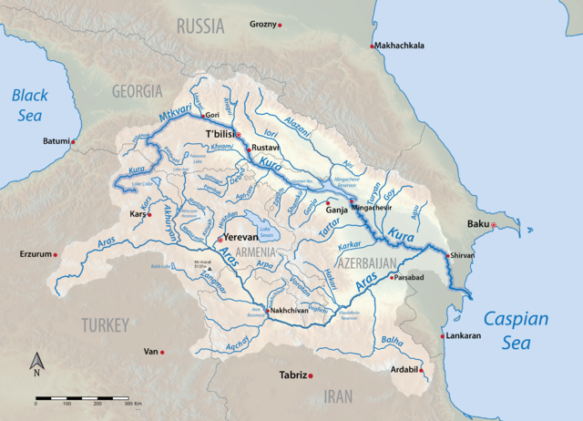
English: Map of the Kura (Mtkvari) river system in Armenia, Azerbaijan, Georgia, Iran and Turkey. More accurate version of my earlier map File:Kurarivermap.jpg. Shaded relief data from US Geological Survey. |
| Datum | |
| Bron | Eigen werk |
| Auteur | Shannon1 |
Licentie
Ik, de auteursrechthebbende van dit werk, maak het hierbij onder de volgende licenties beschikbaar:

|
Toestemming wordt verleend voor het kopiëren, verspreiden en/of wijzigen van dit document onder de voorwaarden van de GNU-licentie voor vrije documentatie, versie 1.2 of enige latere versie als gepubliceerd door de Free Software Foundation; zonder Invariant Sections, zonder Front-Cover Texts, en zonder Back-Cover Texts. Een kopie van de licentie is opgenomen in de sectie GNU-licentie voor vrije documentatie. |
This file is licensed under the Creative Commons Attribution-Share Alike 4.0 International, 3.0 Unported, 2.5 Generic, 2.0 Generic and 1.0 Generic license.
- De gebruiker mag:
- Delen – het werk kopiëren, verspreiden en doorgeven
- Remixen – afgeleide werken maken
- Onder de volgende voorwaarden:
- naamsvermelding – U moet op een gepaste manier aan naamsvermelding doen, een link naar de licentie geven, en aangeven of er wijzigingen in het werk zijn aangebracht. U mag dit op elke redelijke manier doen, maar niet zodanig dat de indruk wordt gewekt dat de licentiegever instemt met uw werk of uw gebruik van zijn werk.
- Gelijk delen – Als u het werk heeft geremixt, veranderd, of erop heeft voortgebouwd, moet u het gewijzigde materiaal verspreiden onder dezelfde licentie als het oorspronkelijke werk, of een daarmee compatibele licentie.
U mag zelf één van de licenties kiezen.
Bestandsgeschiedenis
Klik op een datum/tijd om het bestand te zien zoals het destijds was.
| Datum/tijd | Miniatuur | Afmetingen | Gebruiker | Opmerking | |
|---|---|---|---|---|---|
| huidige versie | 11 mei 2016 18:21 | | 4.329 × 3.123 (4,86 MB) | Shannon1 | accidentally made background transparent |
| 11 mei 2016 18:19 |  | 4.274 × 3.114 (5,15 MB) | Shannon1 | {{Information |Description ={{en|1=Map of the Kura (Mtkvari) river system in Armenia, Azerbaijan, Georgia, Iran and Turkey. More accurate version of my earlier map File:Kurarivermap.jpg. Shaded relief data from US Geological Survey.}} |Source... |
Bestandsgebruik
Dit bestand wordt op de volgende pagina gebruikt:
Globaal bestandsgebruik
De volgende andere wiki's gebruiken dit bestand:
- Gebruikt op af.wikipedia.org
- Gebruikt op ast.wikipedia.org
- Gebruikt op azb.wikipedia.org
- Gebruikt op bn.wikipedia.org
- Gebruikt op ca.wikipedia.org
- Gebruikt op en.wikipedia.org
- Gebruikt op es.wikipedia.org
- Gebruikt op et.wikipedia.org
- Gebruikt op eu.wikipedia.org
- Gebruikt op fa.wikipedia.org
- Gebruikt op fy.wikipedia.org
- Gebruikt op he.wikipedia.org
- Gebruikt op hr.wikipedia.org
- Gebruikt op incubator.wikimedia.org
- Gebruikt op it.wikipedia.org
- Gebruikt op ja.wikipedia.org
- Gebruikt op ka.wikipedia.org
- Gebruikt op lv.wikipedia.org
- Gebruikt op ml.wikipedia.org
- Gebruikt op mt.wikipedia.org
- Gebruikt op no.wikipedia.org
Globaal gebruik van dit bestand bekijken.