
Bestand:LIRR map.svg

Afmetingen van deze voorvertoning van het type PNG van dit SVG-bestand: 512 × 304 pixels Andere resoluties: 320 × 190 pixels | 640 × 380 pixels | 1.024 × 608 pixels | 1.280 × 760 pixels | 2.560 × 1.520 pixels.
Oorspronkelijk bestand (SVG-bestand, nominaal 512 × 304 pixels, bestandsgrootte: 370 kB)
| Dit is een bestand van Wikimedia Commons. Onderstaande beschrijving komt van de beschrijving van het bestand daar. |
Beschrijving
| Beschrijving |
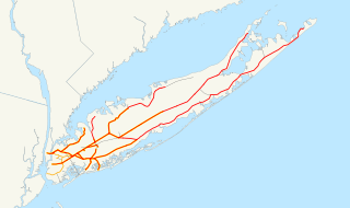
English: This is a map of the rail network currently owned by the Long Island Rail Road. Orange lines are freight-only, and are operated by the New York and Atlantic Railway. Thin black lines have been abandoned. A yellow highlight indicates electrification.
The following GIS data was used:
Deutsch: Karte des Streckennetzes der Long Island Rail Road auf der gleichnamigen Insel.
|
| Datum | 13 december 2006 (originele uploaddatum) |
| Bron | Geen machineleesbare bron opgegeven. Eigen werk aangenomen (gebaseerd op auteursrechtclaims). |
| Auteur | Geen machineleesbare auteur aanwezig. Op basis van auteursrechtclaims wordt auteur NE2 aangenomen. |
Licentie
| Ik, de auteursrechthebbende van dit werk, geef dit werk vrij in het publieke domein. Dit is wereldwijd van toepassing. In sommige landen is dit wettelijk niet mogelijk; in die gevallen geldt: Ik sta iedereen toe dit werk voor eender welk doel te gebruiken, zonder enige voorwaarden, tenzij zulke voorwaarden door de wet worden voorgeschreven. |
Bestandsgeschiedenis
Klik op een datum/tijd om het bestand te zien zoals het destijds was.
| Datum/tijd | Miniatuur | Afmetingen | Gebruiker | Opmerking | |
|---|---|---|---|---|---|
| huidige versie | 10 apr 2017 00:55 | | 512 × 304 (370 kB) | Train2104 | Lower Montauk freight only |
| 23 jan 2007 07:11 |  | 1.152 × 684 (583 kB) | NE2 | Changed the orange. | |
| 23 jan 2007 07:05 |  | 1.152 × 684 (583 kB) | NE2 | Made the black grayer. | |
| 23 jan 2007 07:03 |  | 1.152 × 684 (583 kB) | NE2 | Added a few features. | |
| 13 dec 2006 12:34 |  | 1.152 × 684 (517 kB) | NE2 | This is a map of the rail network currentl[y owned by the Long Island Rail Road. Orange lines are freight-only, and are operated by the New York and Atlantic Railway. The following GIS data was used: *[http://www.bts.gov/publications/north_american_trans |
Bestandsgebruik
Dit bestand wordt op de volgende pagina gebruikt:
Globaal bestandsgebruik
De volgende andere wiki's gebruiken dit bestand:
- Gebruikt op ceb.wikipedia.org
- Gebruikt op da.wikipedia.org
- Gebruikt op de.wikipedia.org
- Gebruikt op en.wikipedia.org
- Gebruikt op es.wikipedia.org
- Gebruikt op et.wikipedia.org
- Gebruikt op fr.wikipedia.org
- Gebruikt op he.wikivoyage.org
- Gebruikt op id.wikipedia.org
- Gebruikt op it.wikipedia.org
- Gebruikt op ja.wikipedia.org
- Gebruikt op ko.wikipedia.org
- Gebruikt op no.wikipedia.org
- Gebruikt op oc.wikipedia.org
- Gebruikt op pl.wikipedia.org
- Gebruikt op pt.wikipedia.org
- Gebruikt op ru.wikipedia.org
- Gebruikt op simple.wikipedia.org
- Gebruikt op sv.wikipedia.org
- Gebruikt op www.wikidata.org
- Gebruikt op zh.wikipedia.org