
Bestand:Leeuwin current 2.jpg
Geen hogere resolutie beschikbaar.
Leeuwin_current_2.jpg (250 × 425 pixels, bestandsgrootte: 30 kB, MIME-type: image/jpeg)
| Dit is een bestand van Wikimedia Commons. Onderstaande beschrijving komt van de beschrijving van het bestand daar. |
Beschrijving
| Beschrijving |
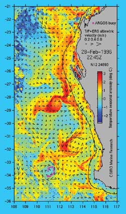
English: Satellite imagery from US NOAA 14 satellite while the surface current velocity is derived from sea level measurements made by the satellite-borne altimeter. Sea level data from the US/French Topex/Poseidon and European ERS altimeters are combined with coastal tide gauge data to make this velocity map. |
| Bron | NOAA |
| Auteur | National Oceanic and Atmospheric Administration |
Licentie
Deze afbeelding is in het publiek domein omdat het materiaal bevat dat oorspronkelijk van de National Oceanic and Atmospheric Administration kwam in de Verenigde Staten en genomen of gemaakt is tijdens de officiële werkzaamheden van een werknemer.
|
Oorspronkelijk uploadlogboek
De oorspronkelijke beschrijving van deze afbeelding stond hier. Alle volgende gebruikersnamen verwijzen naar en.wikipedia.
- 2006-02-22 02:47 John D. Croft 250×425× (30219 bytes) Satellite imagery from US NOAA 14 satellite while the surface current velocity is derived from sea level measurements made by the satellite-borne altimeter. Sea level data from the US/French Topex/Poseidon and European ERS altimeters are combined with coa
Bestandsgeschiedenis
Klik op een datum/tijd om het bestand te zien zoals het destijds was.
| Datum/tijd | Miniatuur | Afmetingen | Gebruiker | Opmerking | |
|---|---|---|---|---|---|
| huidige versie | 19 nov 2012 15:21 | | 250 × 425 (30 kB) | Esprit Fugace | User created page with UploadWizard |
Bestandsgebruik
Dit bestand wordt op de volgende pagina gebruikt:
Globaal bestandsgebruik
De volgende andere wiki's gebruiken dit bestand:
- Gebruikt op ca.wikipedia.org
- Gebruikt op en.wikipedia.org
- Gebruikt op fr.wikipedia.org
- Gebruikt op is.wikipedia.org