
Bestand:Location Tawantin Suyu.png

Grootte van deze voorvertoning: 800 × 370 pixels. Andere resoluties: 320 × 148 pixels | 640 × 296 pixels | 1.357 × 628 pixels.
Oorspronkelijk bestand (1.357 × 628 pixels, bestandsgrootte: 36 kB, MIME-type: image/png)
| Dit is een bestand van Wikimedia Commons. Onderstaande beschrijving komt van de beschrijving van het bestand daar. |
Beschrijving
| Beschrijving |
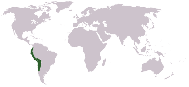
Runa Simi: Tawantin Suyu tarina saywitu.
English: Locator map of the Inca Empire.
Español: Mapa del Imperio Inca |
| Datum | 2 maart 2006 (originele uploaddatum) |
| Bron | Eigen werk |
| Auteur | Huhsunqu |
Origin
Português: Feito e carregado por Huhsunqu.
Runa Simi: Kaytaqa Huhsunqupam tiksishqan yapashqanpis, LocaciónTawantinsuyu.PNG nishqapita rurashqa.
Licentie
Ik, de auteursrechthebbende van dit werk, maak het hierbij onder de volgende licentie beschikbaar:
Dit bestand is gelicenseerd onder de Creative Commons-licentie Naamsvermelding-Gelijk delen 2.5 Unported
- De gebruiker mag:
- Delen – het werk kopiëren, verspreiden en doorgeven
- Remixen – afgeleide werken maken
- Onder de volgende voorwaarden:
- naamsvermelding – U moet op een gepaste manier aan naamsvermelding doen, een link naar de licentie geven, en aangeven of er wijzigingen in het werk zijn aangebracht. U mag dit op elke redelijke manier doen, maar niet zodanig dat de indruk wordt gewekt dat de licentiegever instemt met uw werk of uw gebruik van zijn werk.
- Gelijk delen – Als u het werk heeft geremixt, veranderd, of erop heeft voortgebouwd, moet u het gewijzigde materiaal verspreiden onder dezelfde licentie als het oorspronkelijke werk, of een daarmee compatibele licentie.
Bestandsgeschiedenis
Klik op een datum/tijd om het bestand te zien zoals het destijds was.
| Datum/tijd | Miniatuur | Afmetingen | Gebruiker | Opmerking | |
|---|---|---|---|---|---|
| huidige versie | 19 nov 2006 02:41 | | 1.357 × 628 (36 kB) | Huhsunqu | World (more than 2'000.000 km2) |
| 2 mrt 2006 18:20 |  | 250 × 200 (6 kB) | Huhsunqu | ||
| 2 mrt 2006 18:15 |  | 250 × 200 (5 kB) | Huhsunqu | {{qu|Tawantin Suyu Saywitu}} {{es|Mapa de los terriorios/gobernaciones/provincias (suyukuna) del Imperio Inca}} Category:Inca Category:Former country locator maps ==Origen== Cretaed by Huhsunqu. First uploaded as [[:es:Imagen:LocaciónTawantinsuy |
Bestandsgebruik
Dit bestand wordt op de volgende pagina gebruikt:
Globaal bestandsgebruik
De volgende andere wiki's gebruiken dit bestand:
- Gebruikt op ca.wikipedia.org
- Gebruikt op ckb.wikipedia.org
- Gebruikt op cs.wikipedia.org
- Gebruikt op de.wiktionary.org
- Gebruikt op el.wikipedia.org
- Gebruikt op en.wikipedia.org
- Gebruikt op eo.wikipedia.org
- Gebruikt op es.wikipedia.org
- Gebruikt op he.wikipedia.org
- Gebruikt op io.wikipedia.org
- Gebruikt op mr.wikipedia.org
- Gebruikt op nds.wikipedia.org
- Gebruikt op pl.wikipedia.org
- Gebruikt op pl.wiktionary.org
- Gebruikt op qu.wikipedia.org
- Gebruikt op ro.wikipedia.org
- Gebruikt op simple.wikipedia.org
- Gebruikt op sv.wikipedia.org
- Gebruikt op ta.wikipedia.org
- Gebruikt op ur.wikipedia.org
- Gebruikt op yi.wikipedia.org
- Gebruikt op zh.wikipedia.org