
Bestand:MDT Extension.svg

Afmetingen van deze voorvertoning van het type PNG van dit SVG-bestand: 458 × 600 pixels Andere resoluties: 183 × 240 pixels | 367 × 480 pixels | 587 × 768 pixels | 782 × 1.024 pixels | 1.564 × 2.048 pixels | 1.272 × 1.665 pixels.
Oorspronkelijk bestand (SVG-bestand, nominaal 1.272 × 1.665 pixels, bestandsgrootte: 337 kB)
| Dit is een bestand van Wikimedia Commons. Onderstaande beschrijving komt van de beschrijving van het bestand daar. |
| Beschrijving |
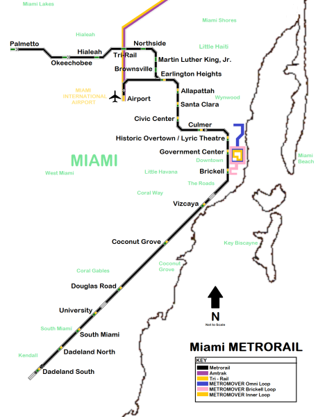
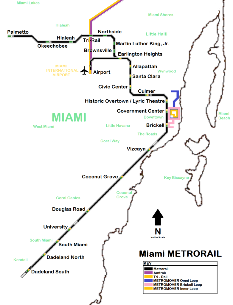
English: Map of Metrorail system and connections |
||
| Datum | |||
| Bron | Eigen werk | ||
| Auteur | Eigen werk | ||
| Toestemming (Hergebruik van dit bestand) |
|
References
Bestandsgeschiedenis
Klik op een datum/tijd om het bestand te zien zoals het destijds was.
| Datum/tijd | Miniatuur | Afmetingen | Gebruiker | Opmerking | |
|---|---|---|---|---|---|
| huidige versie | 7 aug 2011 22:09 | | 1.272 × 1.665 (337 kB) | Leoiv | Yes, that's a schematic map - i know - but it's less informative, we want to give the readers as much info with a map as possible - highly schematic maps do not serve this purpose |
| 7 aug 2011 21:05 |  | 480 × 480 (82 kB) | FrickFrack | It's called a schematic map, like those used by Boston, New York, and other metro systems places | |
| 7 aug 2011 12:50 |  | 1.272 × 1.665 (337 kB) | Leoiv | geographically less accurate, less informative - please make a seperate file, if there is a need for another map | |
| 7 aug 2011 12:50 |  | 480 × 480 (81 kB) | Leoiv | geographically less accurate, less informative - please make a seperate file, if there is a need for another map | |
| 7 aug 2011 06:47 |  | 480 × 480 (355 kB) | FrickFrack | Something better | |
| 7 aug 2011 06:36 |  | 480 × 480 (81 kB) | FrickFrack | Text set | |
| 7 aug 2011 06:17 |  | 480 × 480 (66 kB) | FrickFrack | Smaller, better manageability, same quality | |
| 7 aug 2011 04:09 | Geen miniatuurafbeelding | 0 × 0 (47,17 MB) | FrickFrack | Improved map of entire South Florida rail and rapid transit system | |
| 12 mei 2011 07:15 |  | 1.272 × 1.665 (337 kB) | FrickFrack | better | |
| 9 mei 2011 02:23 |  | 1.272 × 1.665 (336 kB) | FrickFrack | More detailed, with a key |
Bestandsgebruik
Geen enkele pagina gebruikt dit bestand.