
Bestand:Majuro Satellite.PNG

Grootte van deze voorvertoning: 800 × 416 pixels. Andere resoluties: 320 × 167 pixels | 640 × 333 pixels | 1.024 × 533 pixels | 1.918 × 998 pixels.
Oorspronkelijk bestand (1.918 × 998 pixels, bestandsgrootte: 5,49 MB, MIME-type: image/png)
| Dit is een bestand van Wikimedia Commons. Onderstaande beschrijving komt van de beschrijving van het bestand daar. |
Beschrijving
| Beschrijving |
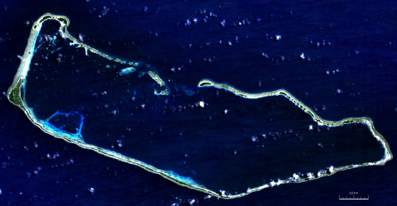
English: visible color satellite image of Majuro Atoll, Marshall Islands, Pacific Ocean |
| Datum | |
| Bron | NASA World Wind Screenshot (visible color) |
| Auteur | NASA |
Licentie
| Deze afbeelding bevindt zich in het publiek domein omdat het een screenshot is van NASA’s software World Wind die gebruik maakt van een publiek domein-laag, zoals Blue Marble, MODIS, Landsat, SRTM, USGS of GLOBE.
|
 |
Bestandsgeschiedenis
Klik op een datum/tijd om het bestand te zien zoals het destijds was.
| Datum/tijd | Miniatuur | Afmetingen | Gebruiker | Opmerking | |
|---|---|---|---|---|---|
| huidige versie | 7 aug 2011 22:17 | | 1.918 × 998 (5,49 MB) | Ratzer | {{Information |Description ={{en|1=true color satellite image of Majuro Atoll, Marshall Islands, Pacific Ocean}} |Source =NASA World Wind Screenshot (true color) |Author =NASA |Date =2000 |Permission = |other_versions = }} |
Bestandsgebruik
Dit bestand wordt op de volgende pagina gebruikt:
Globaal bestandsgebruik
De volgende andere wiki's gebruiken dit bestand:
- Gebruikt op be.wikipedia.org
- Gebruikt op bn.wikipedia.org
- Gebruikt op ceb.wikipedia.org
- Gebruikt op de.wikipedia.org
- Gebruikt op en.wikipedia.org
- Gebruikt op eo.wikipedia.org
- Gebruikt op es.wikipedia.org
- Gebruikt op fi.wikipedia.org
- Gebruikt op fr.wikipedia.org
- Gebruikt op gn.wikipedia.org
- Gebruikt op he.wikipedia.org
- Gebruikt op hi.wikipedia.org
- Gebruikt op id.wikipedia.org
- Gebruikt op ja.wikipedia.org
- Gebruikt op lt.wikipedia.org
- Gebruikt op lv.wikipedia.org
- Gebruikt op ml.wikipedia.org
- Gebruikt op pl.wikipedia.org
- Gebruikt op sat.wikipedia.org
- Gebruikt op sd.wikipedia.org
- Gebruikt op sh.wikipedia.org
- Gebruikt op sl.wikipedia.org
- Gebruikt op sr.wikipedia.org
- Gebruikt op ur.wikipedia.org
- Gebruikt op vep.wikipedia.org
- Gebruikt op www.wikidata.org
- Gebruikt op xmf.wikipedia.org
- Gebruikt op zh.wikivoyage.org