
Bestand:Malikatholhu.png
Geen hogere resolutie beschikbaar.
Malikatholhu.png (374 × 374 pixels, bestandsgrootte: 241 kB, MIME-type: image/png)
| Dit is een bestand van Wikimedia Commons. Onderstaande beschrijving komt van de beschrijving van het bestand daar. |
Beschrijving
| Beschrijving |
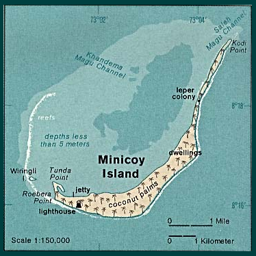
English: Map of Minicoy Island, Lakshadweep, India |
| Datum | |
| Bron | http://www.lib.utexas.edu/maps/islands_oceans_poles/laccadive_minicoy_76.jpg |
| Auteur | Taken from Perry-Castañeda Library (PCL), originally from CIA Indian Ocean Atlas |
| Andere versies |

Licentie
| This image is a work of a Central Intelligence Agency employee, taken or made as part of that person's official duties. As a Work of the United States Government, this image or media is in the public domain in the United States.
|

|
Bestandsgeschiedenis
Klik op een datum/tijd om het bestand te zien zoals het destijds was.
| Datum/tijd | Miniatuur | Afmetingen | Gebruiker | Opmerking | |
|---|---|---|---|---|---|
| huidige versie | 30 mrt 2006 11:39 | | 374 × 374 (241 kB) | Deviathan~commonswiki | Edited from en:Image:Lakshadweep_map.jpg |
Bestandsgebruik
Dit bestand wordt op de volgende pagina gebruikt:
Globaal bestandsgebruik
De volgende andere wiki's gebruiken dit bestand:
- Gebruikt op az.wikipedia.org
- Gebruikt op bn.wikipedia.org
- Gebruikt op de.wikipedia.org
- Gebruikt op en.wikipedia.org
- Gebruikt op en.wikivoyage.org
- Gebruikt op fr.wikipedia.org
- Gebruikt op it.wikipedia.org
- Gebruikt op pl.wikipedia.org
- Gebruikt op ru.wikipedia.org
- Gebruikt op ur.wikipedia.org
- Gebruikt op zh.wikipedia.org