
Bestand:Mansewood1747-1755.jpg

Grootte van deze voorvertoning: 600 × 600 pixels. Andere resoluties: 240 × 240 pixels | 480 × 480 pixels | 768 × 768 pixels.
Oorspronkelijk bestand (768 × 768 pixels, bestandsgrootte: 145 kB, MIME-type: image/jpeg)
| Dit is een bestand van Wikimedia Commons. Onderstaande beschrijving komt van de beschrijving van het bestand daar. |
Beschrijving
| Beschrijving |
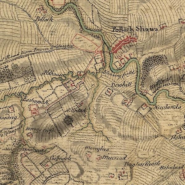
English: Mansewood as depicted in William Roy's Military Survey of Scotland 1747-1755. The Drumlin on which Mansewood is located is shown as the oval shaded area in the lower left. It is bounded by Henry's Croft farm in the South West, the original Eastwood Kirk (now Eastwood Old Cemetery) to the West, Auldhouse to the North and Hillhead House to the North East. |
|||
| Datum | tussen 1747 en 1755 | |||
| Bron |
|
|||
| Auteur | William Roy |


Licentie
|
Dit werk bevindt zich in het publiek domein in landen en gebieden waar de auteursrechttermijn het leven van de auteur plus 100 jaar of minder is. | |
| Van dit bestand is vastgesteld dat er geen bekende auteursrechtaanspraken op rusten, alle aanverwante en naburige rechten daarbij inbegrepen. | |
Bestandsgeschiedenis
Klik op een datum/tijd om het bestand te zien zoals het destijds was.
| Datum/tijd | Miniatuur | Afmetingen | Gebruiker | Opmerking | |
|---|---|---|---|---|---|
| huidige versie | 12 mei 2010 17:26 | | 768 × 768 (145 kB) | Djspatrick | {{Information |Description={{en|1=Mansewood as depicted in William Roy's Military Survey of Scotland 1747-1755. The Drumlin on which Mansewood is located is shown as the oval shaded area in the lower left. It is bounded by Henry's Croft farm in the South |
Bestandsgebruik
Dit bestand wordt op de volgende pagina gebruikt:
Globaal bestandsgebruik
De volgende andere wiki's gebruiken dit bestand:
- Gebruikt op de.wikipedia.org
- Gebruikt op en.wikipedia.org
- Gebruikt op gd.wikipedia.org
- Gebruikt op pt.wikipedia.org